
Searles Lake has long been shaped by shifting water levels, volcanic minerals, and evaporite formation.
In 2024, satellites captured rare water covering the playa. Its mineral-rich brines bear similarities to deposits on asteroid Bennu and Saturn’s moon Enceladus, suggesting shared geological processes across the solar system.
[Editor’s Note: This is the second part of a story about similarities in minerals found at Searles Lake and the asteroid Bennu. Read Part 1.]
Changing Waters: The Shifting Brines of Searles Lake
Water levels at Searles Lake have fluctuated dramatically throughout the Pleistocene, influenced by the region’s topography and the availability of water. Located in a closed basin in the Mojave Desert of southeastern California, the lake is part of a system of five interconnected lakes once fed by the Owens River. The river’s flow has varied significantly over time due to shifts in climate, tectonic activity, and volcanic events.
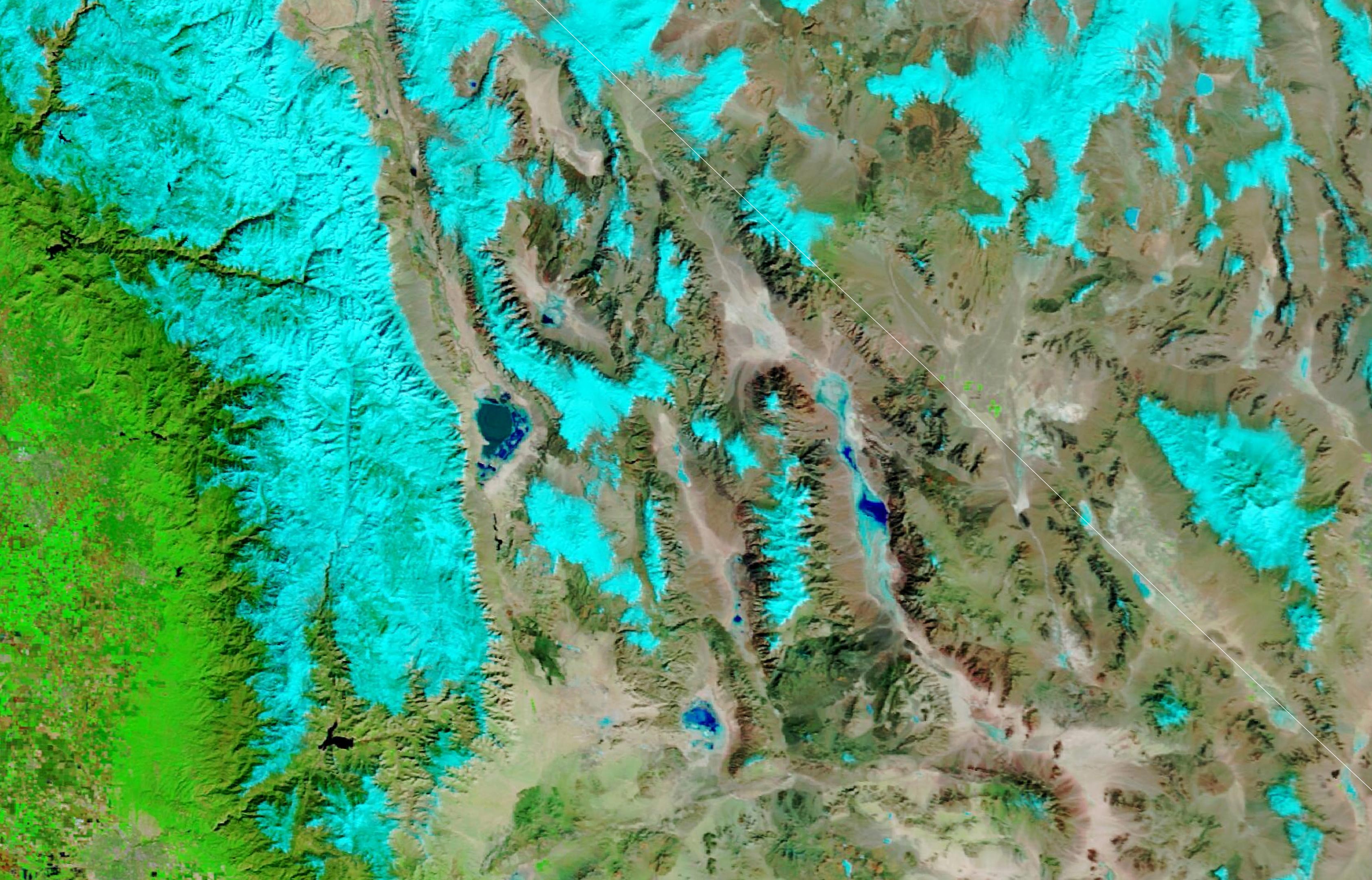
Recent satellite images captured on February 11, 2024, show Searles Lake and nearby playas, typically dry, covered in water following an unusually wet period.
In the natural-color image (upper), the lake appears green, with snow visible as white patches. The false-color image (lower), using bands 7-2-1, enhances contrast between water and land—depicting snow as light blue, water as dark blue, and vegetation as green. Some of the surface water may also result from brine pumped up during mining operations. These images were taken by NASA’s Terra satellite using the Moderate Resolution Imaging Spectroradiometer (MODIS).
Rivers, Overflow, and the Formation of Evaporites
During high-flow periods on the Owens River, Owens Lake would spill into China Lake, then Searles Lake. Searles would overflow into Panamint Lake, then into Lake Manly in Death Valley. Water levels at Searles sometimes rose as high as 700 feet (200 meters) above the current basin floor. When the flow of the river slowed, Searles Lake dried, encouraging the large-scale formation of evaporites—sedimentary deposits of salts produced by the evaporation of water.
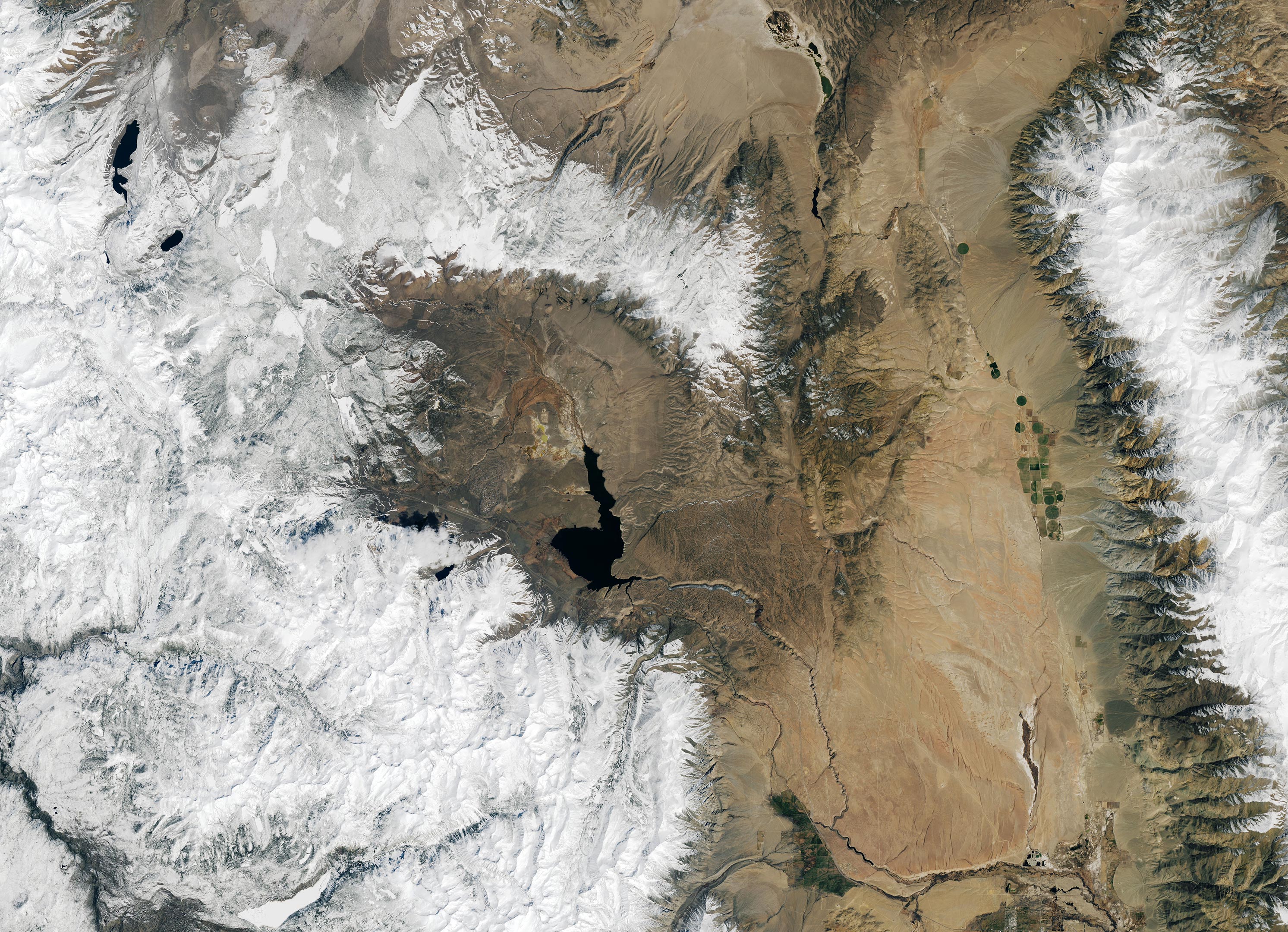
The Owens River provided another key ingredient for the formation of evaporites at Searles Lake—an unusually rich array of dissolved minerals. Weathering of volcanic rocks in Owens Valley and the Long Valley Caldera, a depression left by a massive volcanic explosion, was a key source of these mineral solutes. Geothermal springs rich in ions of sodium, potassium, bicarbonate, and calcium carbonate in the caldera flow into Owens River.
The Operational Land Imager (OLI-2) on Landsat 9 captured the image of the Long Valley Caldera shown above on April 8, 2024. The lower-elevation caldera appears brown while the higher-elevation hills surrounding it are capped with snow. The Owens River flows southeast from Lake Crowley, a reservoir created by damming the river in 1941.
Same Minerals, Different Worlds
Though the properties of the evaporite minerals found on asteroid Bennu make clear that they formed in liquid water, the volume of that water is less well understood. “The water on Bennu’s parent body may have been in quite small pockets, perhaps a meter thick, surrounded by wet, drying mud,” said Tim McCoy, curator of meteorites at the Smithsonian’s National Museum of Natural History and coauthor of a new report about the evaporites found on Bennu published in Nature.
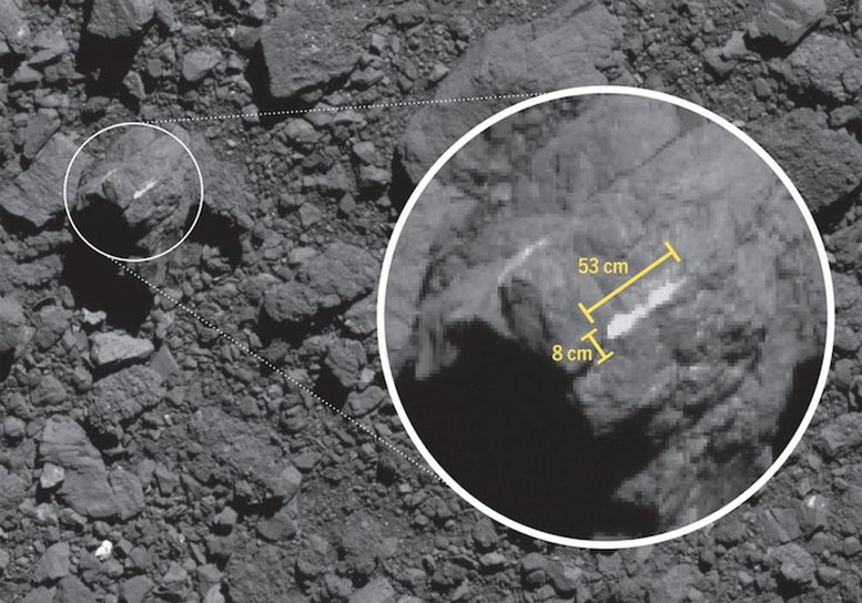
“We know Bennu’s parent body did not have surface lakes or rivers like you see at Searles Lake,” said Hannah Kaplan, a planetary geologist at NASA’s Goddard Space Flight Center. “The water on Bennu’s ancestor likely percolated through the subsurface, between the pores of rocks and through small fractures in hydrothermal systems.” Supporting that idea, images of Bennu obtained by OSIRIS-REx show carbonate veins ranging from 3 to 15 centimeters (1 to 6 inches) on some boulders. The image above shows one of these veins.
A Connection to Distant Worlds: Clues from Ceres and Enceladus
Clues to the nature of this ancient water might be found on the dwarf planet Ceres, where spacecraft have observed similar evaporite minerals on the surface, and on Enceladus, an icy moon of Saturn that emits plumes of water containing sodium salts, McCoy added.
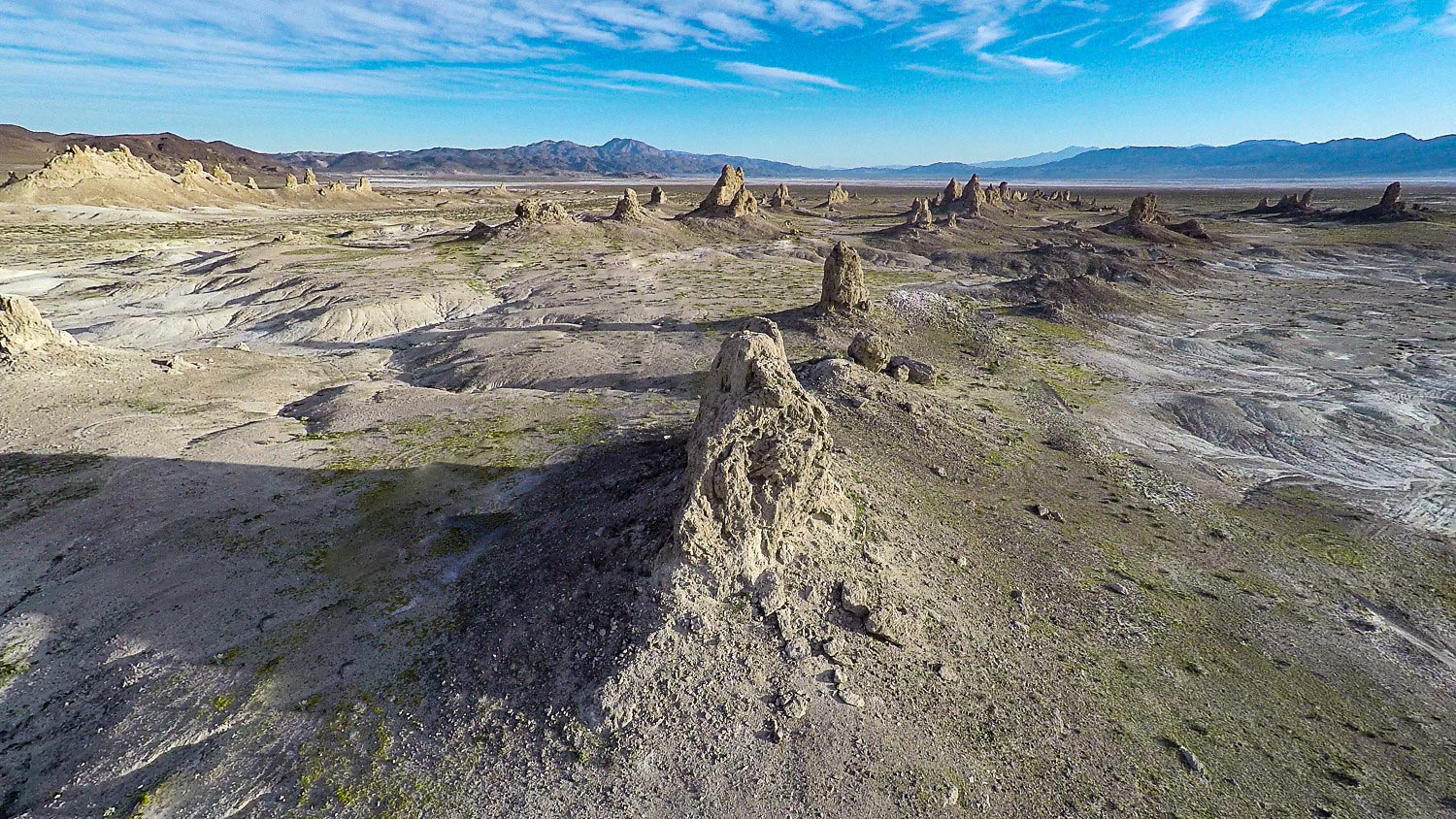
The Trona Pinnacles: Towers from an Ancient Lake
When water levels were high at Searles Lake, the lake produced iconic evaporite formations—tall spires of calcium carbonate (tufa) known as the Trona Pinnacles. The spires, shown above, vary in size and shape, with some rising as high as 140 feet (40 meters).
The spires formed over long periods when Searles Lake had high water levels and hot spring water bubbled up, mixed with alkaline waters, and interacted with communities of algae. The otherworldly features have appeared in movies and shows such as Star Trek V, Lost in Space, Planet of the Apes, and Battlestar Galactica.
“The pinnacles look incredible and are made from calcium carbonate, a mineral we found on Bennu,” said McCoy. “But they’re different in many ways,” cautioned Alfonso Davila, an exobiologist at NASA’s Ames Research Center, noting that the samples on Bennu were tiny flakes, not large-scale deposits like those at Searles Lake.
Mysteries Beyond Earth: The Search for Evaporites Across the Solar System
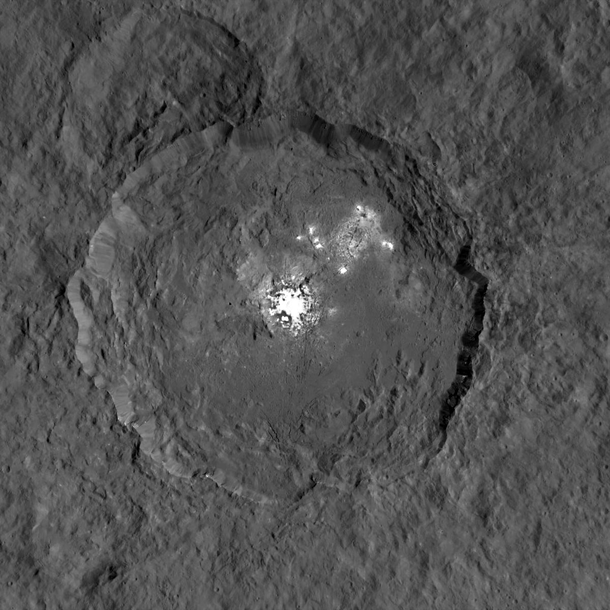
Mars, the dwarf planet Ceres, and Saturn’s moon Titan are other celestial bodies where scientists have discovered large-scale evaporite deposits on the surface, Davila noted. The image above shows a sodium carbonate deposit on Ceres, likely the product of brine spilling across the crater after a meteorite punched a hole into the icy crust.
“Searles Lake offers important clues, but remember that the journey that evaporite minerals on Bennu, Ceres, or Enceladus have gone through was likely quite different in some ways than those at Searles,” Davila said. Earth has an atmosphere, life, liquid oceans, and warm temperatures. “We can’t say all the same things about Bennu.”
NASA Earth Observatory images by Lauren Dauphin, using Landsat data from the U.S. Geological Survey and MODIS data from NASA EOSDIS LANCE and GIBS/Worldview. Bennu OSIRIS-REx photo originally published in Kaplan, et al. courtesy of Hannah Kaplan.
Never miss a breakthrough: Join the SciTechDaily newsletter.
Follow us on Google and Google News.