Close Menu
    Facebook X (Twitter) Instagram
    SciTechDaily
    • Biology
    • Chemistry
    • Earth
    • Health
    • Physics
    • Science
    • Space
    • Technology
    Facebook X (Twitter) Pinterest YouTube RSS
    SciTechDaily
    Home»Earth»Exploring Earth From Space: Lake Mar Chiquita
    Earth

    Exploring Earth From Space: Lake Mar Chiquita

    By European Space AgencyJune 28, 20211 Comment3 Mins Read
    Facebook Twitter Pinterest Telegram LinkedIn WhatsApp Email Reddit
    Share
    Facebook Twitter LinkedIn Pinterest Telegram Email Reddit
    Lake Mar Chiquita Argentina
    Lake Mar Chiquita, Argentina. Credit: Contains modified Copernicus Sentinel data (2020), processed by ESA, CC BY-SA 3.0 IGO

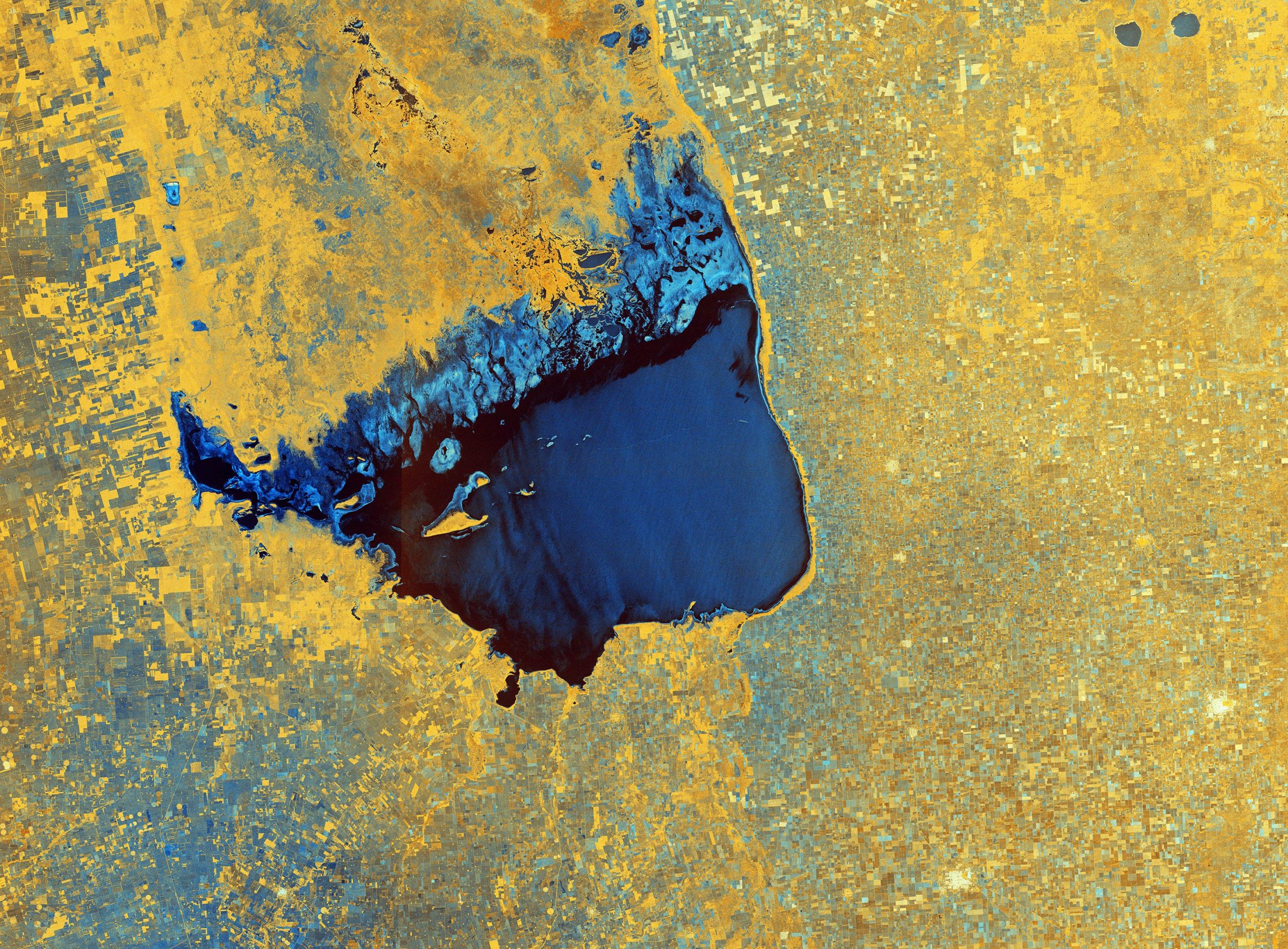
    The Copernicus Sentinel-1 mission takes us over Lake Mar Chiquita – an endorheic salt lake in the northeast province of Córdoba, Argentina.

    Lake Mar Chiquita, around 70 km (43.5 mi) long and 24 km (15 mi) wide, is fed primarily by the Primero and Segundo Rivers from the southwest and from the Dulce River from the north. While these rivers flow into the lake, there isn’t a natural outflow of water so it only loses water by evaporation, hence Lake Mar Chiquita being described as an endorheic lake. The lake’s surface area, as well as its salinity, varies considerably (ranging between 2,000 and 6,000 sq km or 770 and 2,300 sq mi), although it is slowly diminishing in size owing to evaporation.

    Several small islands lie in the lake, the most important of which is El Médano. Vast expanses of saline marshes can be seen on the lake’s northern shore. The lake has been designated as a Ramsar Site of International Importance, and is considered one of the most important wetlands in Argentina owing to its rich biodiversity. Over 25 species of fish are known to breed in Lake Mar Chiquita, with fishing and livestock being the principal land uses.

    The colors of this week’s image come from the combination of two polarizations from the Sentinel-1 radar mission, which have been converted into a single image.

    As radar images provide data in a different way than a normal optical camera, the images are usually black and white when they are received. By using a technology that aligns the radar beams sent and received by the instrument in one orientation – either vertically or horizontally – the resulting data can be processed in a way that produces colored images such as the one featured here. This technique allows scientists to better analyze Earth’s surface.

    Shades of blue in the image show us where the differences between the two polarizations are higher, for example, the saline marshes in the lake’s north, whereas the crops and agricultural fields in the surrounding area appear yellow, indicating fewer differences between polarizations. Fields, such as those visible in the bottom-left corner of the image, appear blue most likely because they are wetter. Several villages, including San Francisco and Rafaela, are identifiable in white in the bottom-right of the image.

    Never miss a breakthrough: Join the SciTechDaily newsletter.
    Follow us on Google and Google News.

    European Space Agency Geography
    Share. Facebook Twitter Pinterest LinkedIn Email Reddit

    Related Articles

    Breathtaking View of Andros, Bahamas From Space [Video]

    Stunning Views of Houston Texas From Copernicus Sentinel-1 Satellite

    Earth From Space: Bolivian Highland Heart [Video]

    Flevoland, Netherlands From Space: One of the Largest Land Reclamation Projects in the World

    Earth From Space: Lake George, Uganda – A Center for Biological Diversity [Video]

    Deforestation in Bolivia Spied From Space Satellite

    Earth From Space: Japanese Archipelago [Video]

    Earth From Space: Faroe Islands [Video]

    Earth From Space: Tromsø, Norway [Video]

    1 Comment

    1. Clyde Spencer on June 28, 2021 6:35 am

      “By using a technology that aligns the radar beams sent and received by the instrument in one orientation – either vertically or horizontally – the resulting data can be processed in a way that produces colored images such as the one featured here.”

      You are making it harder than necessary! The two co-registered images are directed to be displayed in any two primary colors of the display device. This is known as a false-color image and is commonly done for three bands of different wavelengths instead of different polarizations.

      Reply
    Leave A Reply Cancel Reply

    • Facebook
    • Twitter
    • Pinterest
    • YouTube

    Don't Miss a Discovery

    Subscribe for the Latest in Science & Tech!

    Trending News

    The Best Exercise Combination for Longevity, According to a 30-Year Study

    Popular Weight-Loss Drug Found To Slow Biological Aging in Landmark Human Trial

    NASA’s Fermi Telescope Caught a Supernova Doing Something Never Seen Before

    This Dinosaur Had the Claws of a Raptor but Hunted Like a Heron

    Doctors May Need To Rethink Calcium and Vitamin D Recommendations After Major Review

    Scientists Discover a Hidden Cause of Cellular Aging That Can Be Reversed

    Archaeologists Have Found Something Unexpected Inside a 1,600-Year-Old Egyptian Mummy

    Scientists May Have Found a Completely New Way To Treat Depression

    Follow SciTechDaily
    • Facebook
    • Twitter
    • YouTube
    • Pinterest
    • Newsletter
    • RSS
    SciTech News
    • Biology News
    • Chemistry News
    • Earth News
    • Health News
    • Physics News
    • Science News
    • Space News
    • Technology News
    Recent Posts
    • A Newly Found Cellular Shift May Explain Why Aging Leads to Disease
    • A Normal Kidney Test Could Still Signal Serious Risk
    • Scientists Discover Gut Signal That Turns Off Sugar Cravings
    • NASA Captures Typhoon Jangmi’s Massive Eye in Stunning Nighttime Image
    • Super Typhoon Sinlaku Was So Powerful It Made the Sky Ripple With Gravity Waves
    Copyright © 1998 - 2026 SciTechDaily. All Rights Reserved.
    • Science News
    • About
    • Contact
    • Editorial Board
    • Privacy Policy
    • Terms of Use

    Type above and press Enter to search. Press Esc to cancel.