
Close Menu
    Facebook X (Twitter) Instagram
    SciTechDaily
    • Biology
    • Chemistry
    • Earth
    • Health
    • Physics
    • Science
    • Space
    • Technology
    Facebook X (Twitter) Pinterest YouTube RSS
    SciTechDaily
    Home»Earth»Exploring Earth From Space: Mount Aso – The Largest Active Volcano in Japan
    Earth

    Exploring Earth From Space: Mount Aso – The Largest Active Volcano in Japan

    By European Space Agency (ESA)April 30, 2022No Comments3 Mins Read
    Facebook Twitter Pinterest Telegram LinkedIn WhatsApp Email Reddit
    Share
    Facebook Twitter LinkedIn Pinterest Telegram Email Reddit
    Mount Aso Japan
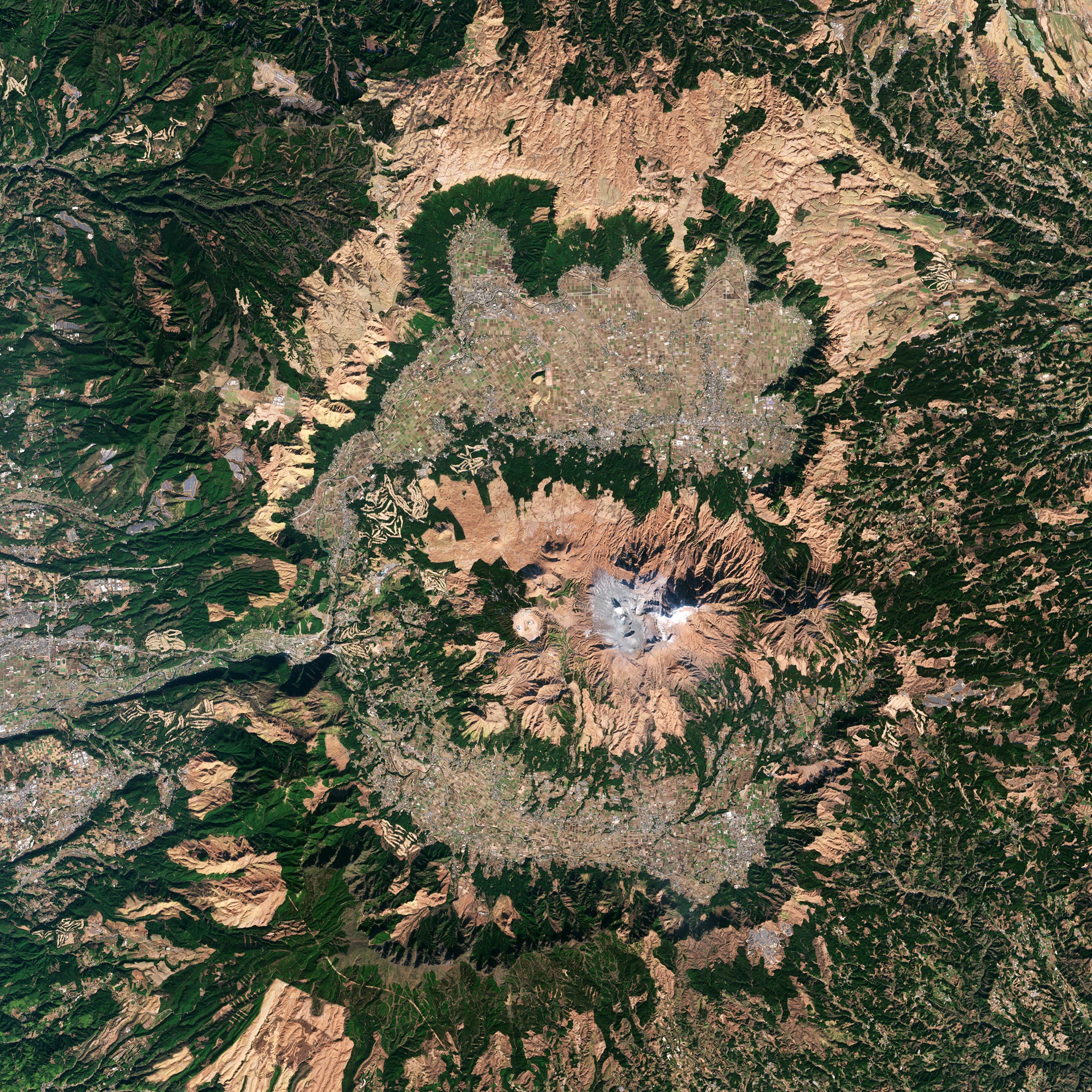
    Mount Aso, the largest active volcano in Japan, is featured in this image captured on January 1, 2022, by the Copernicus Sentinel-2 mission. Credit: Contains modified Copernicus Sentinel data (2022), processed by ESA, CC BY-SA 3.0 IGO

    Mount Aso, the largest active volcano in Japan, is featured in this image captured by the Copernicus Sentinel-2 mission.

    Mount Aso, located in the Kumamoto Prefecture on the nation’s southernmost main island of Kyushu, rises to a height of 1592 meters (5,223 feet). The Aso Caldera is one of the world’s biggest calderas, stretching around 120 km (75 miles) in circumference, 25 km (16 miles) north to south, and 18 km (11 miles) east to west.

    The caldera was formed during four major explosive eruptions that occurred between 90,000 and 270,000 years ago. This resulted in massive pyroclastic flows and volcanic ash that blanketed much of the Kyushu region and even reached the neighboring Yamaguchi Prefecture.

    The caldera is surrounded by five peaks known collectively as Aso Gogaku: Nekodake, Takadake, Nakadake, Eboshidake, Kishimadake. Nakadake is the only active volcano at the center of Mount Aso and is the main attraction in the region. The volcano goes through cycles of activity. At its calmest, the crater fills with a lime green lake that gently steams, but as activity increases, the lake boils off and disappears. The volcano has been erupting sporadically for decades, most recently in 2021, which has led to the number of visitors drop in recent years.

    Not far from the crater lies Kusasenri: a vast grassland inside the mega crater of Eboshidake. Active just over 20,000 years ago, the crater has been filled with volcanic pumice from other eruptions, with magma still brewing a few kilometers below. Rainwater often accumulates on the plain forming temporary lakes. The pastures are used for cattle raising, dairy farming, and horse riding.

    One of the nearest populated cities is Aso, visible in the image around 8 km (5 miles) north of the volcano. It has a population of around 26,000 people.

    There are 110 active volcanoes in Japan, of which 47 are monitored closely as they have erupted recently or shown worrying signs including seismic activity, ground deformation, or emissions of large amounts of smoke.

    Satellite data can be used to detect the slight signs of change that may foretell an eruption. Once an eruption begins, optical and radar instruments can capture the various phenomena associated with it, including lava flows, mudslides, ground fissures, and earthquakes. Atmospheric sensors on satellites can also identify the gases and aerosols released by the eruption, as well as quantify their wider environmental impact.

    This image is also featured on the Earth From Space video program embedded above.

    Never miss a breakthrough: Join the SciTechDaily newsletter.
    Follow us on Google and Google News.

    European Space Agency Geography Volcano
    Share. Facebook Twitter Pinterest LinkedIn Email Reddit

    Related Articles

    Mount Fuji’s Snow-Free Streak Finally Ends

    Mount Etna’s Fiery Fury: Lava and Ash Eruption Towers Over Sicily

    Eerie Beauty of Kawah Ijen’s Menacing Waters: World’s Largest Acidic Cauldron Unveiled

    Nishinoshima, Japan: Satellite Captures a Fiery Island’s Explosive Growth

    Stunning Photo Captured From Space: New Eruption at Krakatoa Volcano

    Sulfur Dioxide From Massive Volcanic Eruption Near Tonga Spreads Over Australia

    Stunning Satellite Image Shows Lava Burning a Path to the Sea From La Palma Volcano

    Earth From Space: Awe-Inspiring Vatnajökull, Iceland [Video]

    Earth From Space: Great Rift Valley, Kenya – Shaped by Major Tectonic and Volcanic Activity

    Leave A Reply Cancel Reply

    • Facebook
    • Twitter
    • Pinterest
    • YouTube

    Don't Miss a Discovery

    Subscribe for the Latest in Science & Tech!

    Trending News

    Tea or Coffee? Your Daily Choice Could Affect Osteoporosis Risk

    Vitamin C May Fight Cancer in a Surprising Way

    Hidden Earthquake Threat: Oregon’s Fault May Be Closer to the Surface Than Scientists Thought

    Scientists Discover Hidden Sleep Switch That Boosts Brainpower, Builds Muscle, and Burns Fat

    Ancient Mega-Floods Once Ripped Across Mars and Left This Giant Scar

    Scientists Discover Cheap, Natural Remedy for High Blood Pressure

    Earth’s Upper Atmosphere Is Cooling Fast and Scientists Finally Know Why

    32,000 Olympic Pools of Magma Nearly Erupted Beneath Atlantic Island

    Follow SciTechDaily
    • Facebook
    • Twitter
    • YouTube
    • Pinterest
    • Newsletter
    • RSS
    SciTech News
    • Biology News
    • Chemistry News
    • Earth News
    • Health News
    • Physics News
    • Science News
    • Space News
    • Technology News
    Recent Posts
    • Scientists Are Turning Ocean Trash Into Roads – and It’s Actually Working
    • This Alien Planet Has Rock Clouds That Vaporize Before Sunset
    • The Coldest “Stars” in the Galaxy Might Actually Be Alien Megastructures
    • The Simple Habit That Could Lower Your Cancer Risk
    • New AI Blood Test Predicts Stroke, Heart Failure, and More up to 15 Years in Advance
    Copyright © 1998 - 2026 SciTechDaily. All Rights Reserved.
    • Science News
    • About
    • Contact
    • Editorial Board
    • Privacy Policy
    • Terms of Use

    Type above and press Enter to search. Press Esc to cancel.