
Close Menu
    Facebook X (Twitter) Instagram
    SciTechDaily
    • Biology
    • Chemistry
    • Earth
    • Health
    • Physics
    • Science
    • Space
    • Technology
    Facebook X (Twitter) Pinterest YouTube RSS
    SciTechDaily
    Home»Earth»Exploring Earth From Space: Patagonia and the Falkland Islands
    Earth

    Exploring Earth From Space: Patagonia and the Falkland Islands

    By European Space Agency (ESA)July 3, 2022No Comments3 Mins Read
    Facebook Twitter Pinterest Telegram LinkedIn WhatsApp Email Reddit
    Share
    Facebook Twitter LinkedIn Pinterest Telegram Email Reddit
    Patagonia From Space
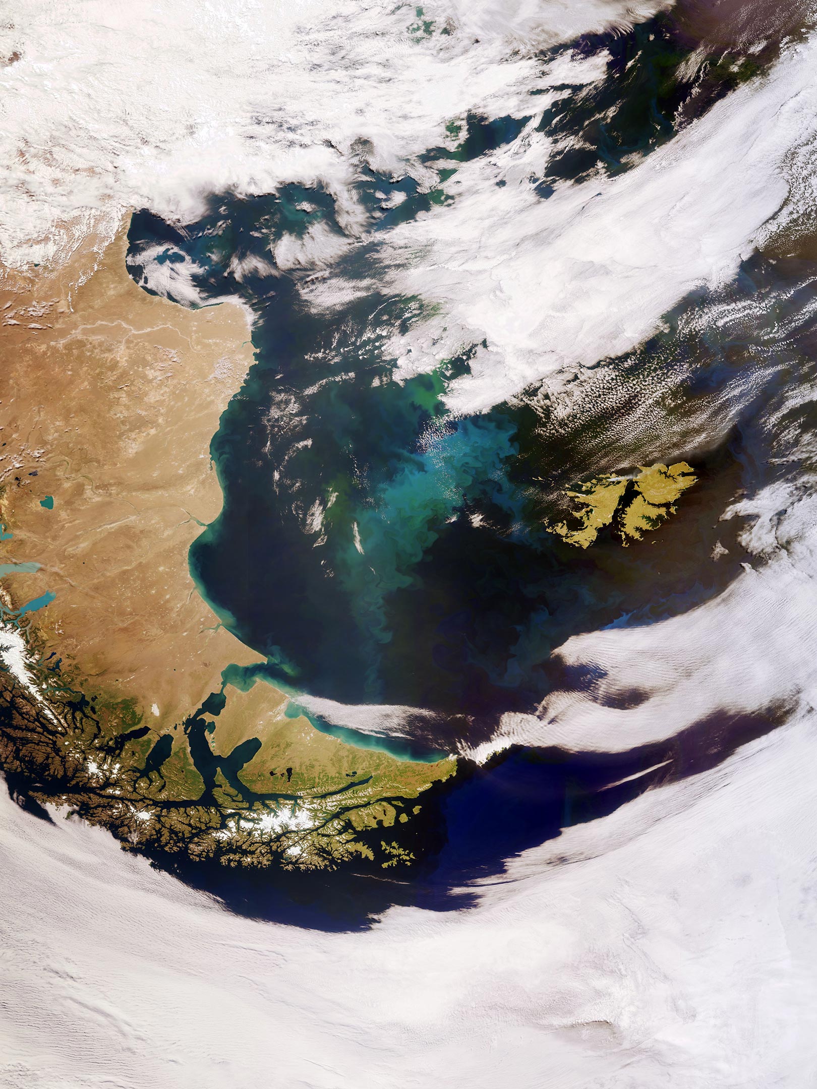
    (Click image for full view.) The Copernicus Sentinel-3 mission captured this satellite view of Patagonia at the southern end of South America and the Falkland Islands (Malvinas). Credit: Contains modified Copernicus Sentinel data (2022), processed by ESA, CC BY-SA 3.0 IGO

    This impressive, wide-angled view of Patagonia at the southern end of South America, as well as the Falkland Islands (Malvinas) was captured by the European Space Agency’s Copernicus Sentinel-3 mission.

    Covering an area of around 673,000 sq km (260,000 sq miles), Patagonia is split by Argentina and Chile. The region comprises the southern section of the Andes Mountains, with lakes, fjords, rainforests, and glaciers in the west and deserts and tablelands to the east.

    Tierra del Fuego, an island archipelago located at the southern tip of Patagonia (the southernmost tip of the image), is shared by Argentina and Chile. However, the eastern part of the main island belongs to Argentina, and the southern point of the archipelago, which forms Cape Horn, belongs to Chile. The Strait of Magellan, named after the discoverer Ferdinand Magellan, lies between Tierra del Fuego and mainland Argentina.

    Part of the Alberto de Agostini National Park can be seen at the bottom of the image. The park features a highly irregular coastline, which is deeply indented by fjords. Deemed a designated UNESCO Biosphere Reserve, the park has several tidewater glaciers and comprises the islands of Gordon, Cook, and Londonderry.

    The Falkland Islands can be seen in the far right of the image. The islands lie in the South Atlantic Ocean, around 600 km (370 miles) east of Patagonia. The Falklands comprise two main islands, West Falkland and East Falkland, separated by the Falkland Sound – a channel that averages around 20 km (12 miles) in width.

    The swirling green and blue colored areas are densely concentrated phytoplankton blooms. These microscopic organisms thrive in the cool, nutrient-rich waters between the coast of southern Argentina and the Falkland Islands. Nutrients carried by rivers promote phytoplankton growth, which may explain the plankton hugging the South American coastline in the image, as well as dust carried from Patagonia offshore which is then diffused on the ocean surface by strong westerly winds.

    In spring and summer, populations of algae in the South Atlantic often explode into enormous blooms – which float with the meandering ocean currents. Carrying a suite of cutting-edge instruments, Copernicus Sentinel-3 measures systematically Earth’s oceans, land, ice, and atmosphere to monitor and understand large-scale global dynamics.

    Sentinel-3 measures the temperature, color, and height of the sea surface as well as the thickness of sea ice, while over land maps land, provides indices of vegetation state, and measures the height of rivers and lakes.

    This image is also featured on the Earth From Space video program embedded above.

    Never miss a breakthrough: Join the SciTechDaily newsletter.
    Follow us on Google and Google News.

    European Space Agency Geography
    Share. Facebook Twitter Pinterest LinkedIn Email Reddit

    Related Articles

    Breathtaking View of Andros, Bahamas From Space [Video]

    Stunning Views of Houston Texas From Copernicus Sentinel-1 Satellite

    Earth From Space: Bolivian Highland Heart [Video]

    Flevoland, Netherlands From Space: One of the Largest Land Reclamation Projects in the World

    Earth From Space: Lake George, Uganda – A Center for Biological Diversity [Video]

    Deforestation in Bolivia Spied From Space Satellite

    Earth From Space: Japanese Archipelago [Video]

    Earth From Space: Faroe Islands [Video]

    Earth From Space: Tromsø, Norway [Video]

    Leave A Reply Cancel Reply

    • Facebook
    • Twitter
    • Pinterest
    • YouTube

    Don't Miss a Discovery

    Subscribe for the Latest in Science & Tech!

    Trending News

    Popular Sugar-Free Sweetener Linked to Liver Disease, Study Warns

    What Is Hantavirus? The Deadly Disease Raising Alarm Worldwide

    Scientists Just Discovered How the Universe Builds Monster Black Holes

    Scientists Unveil New Treatment Strategy That Could Outsmart Cancer

    A Simple Vitamin May Hold the Key to Treating Rare Genetic Diseases

    Scientists Think the Real Fountain of Youth May Be Hiding in Your Gut

    Ravens Don’t Follow Wolves, They Predict Them

    This Common Knee Surgery May Be Doing More Harm Than Good

    Follow SciTechDaily
    • Facebook
    • Twitter
    • YouTube
    • Pinterest
    • Newsletter
    • RSS
    SciTech News
    • Biology News
    • Chemistry News
    • Earth News
    • Health News
    • Physics News
    • Science News
    • Space News
    • Technology News
    Recent Posts
    • Why Are So Many New Fathers Dying? Scientists Say the U.S. Has a Dangerous Blind Spot
    • Scientists Identify Simple Supplement That Greatly Reduces Alzheimer’s Damage
    • You May Have a Dangerous Type of Cholesterol Even if Your Tests Look Normal
    • Study Reveals Dangerous Flaw in AI Symptom Checkers
    • New MRI Breakthrough Captures Stunningly Clear Images of the Eye and Brain
    Copyright © 1998 - 2026 SciTechDaily. All Rights Reserved.
    • Science News
    • About
    • Contact
    • Editorial Board
    • Privacy Policy
    • Terms of Use

    Type above and press Enter to search. Press Esc to cancel.