
Close Menu
    Facebook X (Twitter) Instagram
    SciTechDaily
    • Biology
    • Chemistry
    • Earth
    • Health
    • Physics
    • Science
    • Space
    • Technology
    Facebook X (Twitter) Pinterest YouTube RSS
    SciTechDaily
    Home»Earth»Exploring Earth From Space: Tenerife, Canary Islands
    Earth

    Exploring Earth From Space: Tenerife, Canary Islands

    By European Space Agency (ESA)February 20, 2022No Comments3 Mins Read
    Facebook Twitter Pinterest Telegram LinkedIn WhatsApp Email Reddit
    Share
    Facebook Twitter LinkedIn Pinterest Telegram Email Reddit
    Tenerife Canary Islands
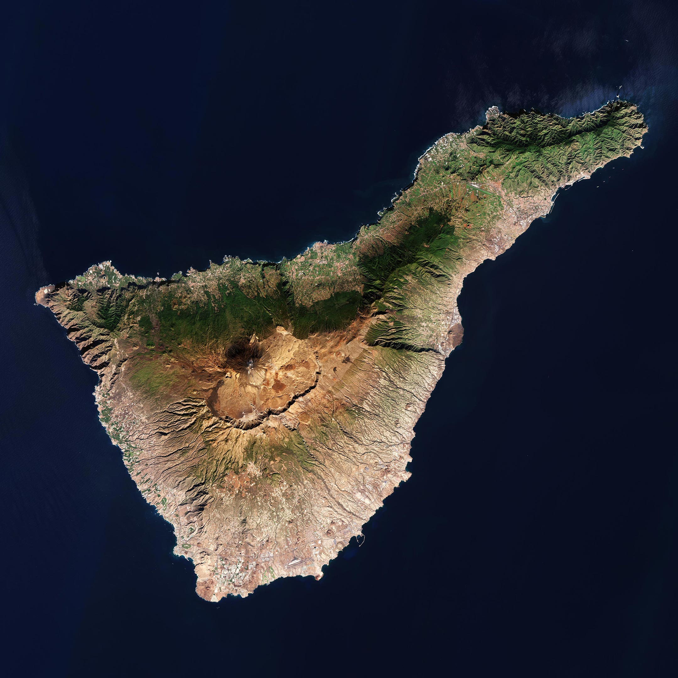
    Tenerife, the largest of Spain’s Canary Islands, captured by the Copernicus Sentinel-2 mission. Credit: Contains modified Copernicus Sentinel (2021), processed by ESA, CC BY-SA 3.0 IGO

    The Copernicus Sentinel-2 mission takes us over Tenerife – the largest of Spain’s Canary Islands.

    Located in the Atlantic Ocean, opposite the northwest coast of Africa, the Canary Islands consist of eight main islands including Gran Canaria, Lanzarote and La Palma, as well as many small islands and islets.

    Teide National Park, located in the center of the island, is a UNESCO World Heritage Site and includes Mount Teide which dominates the island. Standing at around 3,718 m (12,198 ft), its summit is the highest point on Spanish soil. However, much of the volcano’s height is hidden. If measured from the ocean floor, its height of 7,500 m (24,600 ft) makes Teide the third-highest volcano in the world.

    Teide is an active volcano: its most recent eruption occurred in 1909 when a lava flow buried much of the town and harbor of Garachico on the northern coast.

    Owing to the island’s diverse topography and unique climatic factors, Tenerife has multiple microclimates, which means that the weather can vary drastically from one part of the island to the other. Weather and climate are heavily influenced by the trade winds blowing from the northeast for most of the year, bringing humidity and precipitation to the north of the island, as well as to the northern slopes of Mount Teide.

    This effect can be clearly seen in the dark green colors in the image showing vegetation cover. This band of green generally follows the boundary of Corona Forestal Natural Park, which covers a total area of 46,000 hectares.

    Most of Tenerife’s inhabitants live on the lower slopes, within a few kilometers of the sea. Around half the population is in or near the cosmopolitan capital of Santa Cruz de Tenerife, on the narrower northeast part of the island, and San Cristóbal de la Laguna, the former capital.

    Other inhabitants live on the intensively cultivated slopes near the northern coast, where the chief towns are La Orotava, Los Realejos, and Puerto de la Cruz. The south is a popular destination where holidaymakers enjoy time on the beautiful beaches of Costa Adeje.

    Tenerife is home to Teide Observatory, located around 10 km (6.2 mi) from Santa Cruz de Tenerife on the Izaña mountain, which is home to ESA’s IZN-1 laser ranging station – the first laser ranging station to be made commercially available. It is here where lasers are aimed into Earth’s skies, seeking out satellites and soon pieces of space rubbish, as well as measuring their positions and trajectories to prevent catastrophic collisions.

    The station, telescope and laser have recently undergone months of testing and commissioning and have passed their final tests with flying colors. Read more about ESA’s laser ranging station.

    Never miss a breakthrough: Join the SciTechDaily newsletter.
    Follow us on Google and Google News.

    European Space Agency Geography
    Share. Facebook Twitter Pinterest LinkedIn Email Reddit

    Related Articles

    Breathtaking View of Andros, Bahamas From Space [Video]

    Stunning Views of Houston Texas From Copernicus Sentinel-1 Satellite

    Earth From Space: Bolivian Highland Heart [Video]

    Flevoland, Netherlands From Space: One of the Largest Land Reclamation Projects in the World

    Earth From Space: Lake George, Uganda – A Center for Biological Diversity [Video]

    Deforestation in Bolivia Spied From Space Satellite

    Earth From Space: Japanese Archipelago [Video]

    Earth From Space: Faroe Islands [Video]

    Earth From Space: Tromsø, Norway [Video]

    Leave A Reply Cancel Reply

    • Facebook
    • Twitter
    • Pinterest
    • YouTube

    Don't Miss a Discovery

    Subscribe for the Latest in Science & Tech!

    Trending News

    Breakthrough Parkinson’s Drug Targets Disease at Its Genetic Roots

    Just 4 Weeks of Simple Diet Changes Reversed Signs of Aging in Older Adults

    Scientists May Have Finally Solved Why Humans Are Right-Handed

    NASA’s Hubble Accidentally Witnesses a Comet Shattering in Space

    Researchers Discover the Body’s Hidden “Off Switch” for Inflammation

    Scientists Discover Metformin Doesn’t Work the Way We Thought

    Tea or Coffee? Your Daily Choice Could Affect Osteoporosis Risk

    Vitamin C May Fight Cancer in a Surprising Way

    Follow SciTechDaily
    • Facebook
    • Twitter
    • YouTube
    • Pinterest
    • Newsletter
    • RSS
    SciTech News
    • Biology News
    • Chemistry News
    • Earth News
    • Health News
    • Physics News
    • Science News
    • Space News
    • Technology News
    Recent Posts
    • Scientists Say a 59,000-Year-Old Neanderthal Tooth Shows Evidence of Surgery
    • Scientists Stunned by Hybrid California Bees That Beat Deadly Mites
    • Scientists Discover Terrifying Giant Crocodile That Hunted Human Ancestors
    • Scientists Finally Think They Know Why T. rex Had Tiny Arms
    • Scientists Are Turning Ocean Trash Into Roads – and It’s Actually Working
    Copyright © 1998 - 2026 SciTechDaily. All Rights Reserved.
    • Science News
    • About
    • Contact
    • Editorial Board
    • Privacy Policy
    • Terms of Use

    Type above and press Enter to search. Press Esc to cancel.