Close Menu
    Facebook X (Twitter) Instagram
    SciTechDaily
    • Biology
    • Chemistry
    • Earth
    • Health
    • Physics
    • Science
    • Space
    • Technology
    Facebook X (Twitter) Pinterest YouTube RSS
    SciTechDaily
    Home»Earth»Gigafire! August Complex Wildfire Still Burning – Largest Fire in California’s History
    Earth

    Gigafire! August Complex Wildfire Still Burning – Largest Fire in California’s History

    By Lynn Jenner, NASA Goddard Space Flight CenterOctober 7, 2020No Comments3 Mins Read
    Facebook Twitter Pinterest Telegram LinkedIn WhatsApp Email Reddit
    Share
    Facebook Twitter LinkedIn Pinterest Telegram Email Reddit
    Suomi NPP Satellite August Complex Wildfire
    NOAA/NASAs Suomi NPP satellite image shows a true-color image of the August Complex and other nearby fires. The August Complex is now the largest fire in the states history as well as a “gigafire” meaning over 1,000,000 acres have been consumed by the blaze. Credit: NOAA/NASA/Worldview

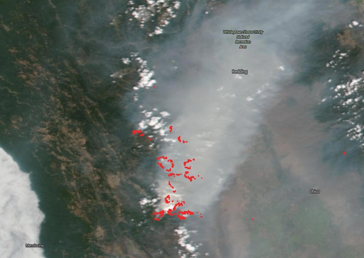
    NOAA/NASA’s Suomi NPP satellite captured another startling image of the August Complex of fires that has grown to over 1,000,000 acres burned (1,006,140 acres total) and because of that grim milestone the complex has been dubbed a “gigafire.” The August Complex is only 58% contained.  Inciweb reports that: “In the northeast zone, active behavior continues. Structures in Hidden Valley, Trinity Pines/Post Mountain, Wildwood and Platina are threatened by fire spread. Short range spotting and fire spread toward Hidden Valley has increased potential for impact to structures.”

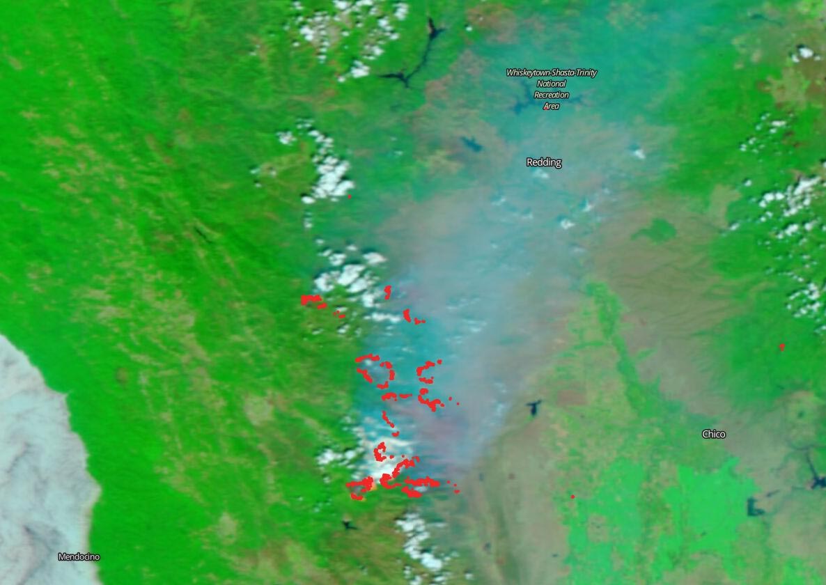
    Another view that can be captured by Suomi NPP satellite is a false-color image. The false-color image is collected by the VIIRS (Visible Infrared Imaging Radiometer Suite) instrument suite using corrected reflectance bands. Burned areas or fire-affected areas are characterized by deposits of charcoal and ash, removal of vegetation and/or the alteration of vegetation structure. When bare soil becomes exposed, the brightness in Band 1 may increase, but that may be offset by the presence of black carbon residue; the near infrared (Band 2) will become darker, and Band 7 becomes more reflective. When assigned to red/brown in the image, Band 7 will show burn scars as deep or bright reddish brown depending on the type of vegetation burned, the amount of residue, or the completeness of the burn. It is hard to see clearly due to the massive amounts of smoke covering the landscape.

    Suomi NPP Satellite August Complex Burn Area
    This image from NOAA/NASAs Suomi NPP satellite shows shows the areas that have been burned in the August Complex fire. Those areas show up as a light to dark brown. The area burned by this complex of fires is larger than the state of Rhode Island. Credit: NOAA/NASA/Worldview

    Inciweb reports the following weather concerns for this fires: “Hot and dry conditions persist. Smoke remains very thick in the lower valleys with visibility reduced under a mile. Temperatures will be 88-93 in the valleys and 75 to 80 in the higher elevations. The humidity will be 10-15% with 4-8 mph wind.”

    NASA’s satellite instruments are often the first to detect wildfires burning in remote regions, and the locations of new fires are sent directly to land managers worldwide within hours of the satellite overpass. Together, NASA instruments detect actively burning fires, track the transport of smoke from fires, provide information for fire management, and map the extent of changes to ecosystems, based on the extent and severity of burn scars. NASA has a fleet of Earth-observing instruments, many of which contribute to our understanding of fire in the Earth system. Satellites in orbit around the poles provide observations of the entire planet several times per day, whereas satellites in a geostationary orbit provide coarse-resolution imagery of fires, smoke and clouds every five to 15 minutes.

    NASA’s Earth Observing System Data and Information System (EOSDIS) Worldview application provides the capability to interactively browse over 700 global, full-resolution satellite imagery layers and then download the underlying data. Many of the available imagery layers are updated within three hours of observation, essentially showing the entire Earth as it looks “right now.” Actively burning fires, detected by thermal bands, are shown as red points. Image Courtesy: NASA Worldview, Earth Observing System Data and Information System (EOSDIS).

    Never miss a breakthrough: Join the SciTechDaily newsletter.
    Follow us on Google and Google News.

    NASA NASA Goddard Space Flight Center Wildfires
    Share. Facebook Twitter Pinterest LinkedIn Email Reddit

    Related Articles

    NASA’s Terra Satellite Captures Smoky Pall Over California After Unprecedented Lightning Strikes Ignite More Than 650 Wildfires

    1200+ Mile Trail of Smoke Stretches Across California in These NASA Terra Images of the Wildfires

    63 Mile Smoke Trail From Bighorn Fire Captured by NOAA/NASA Satellite

    Latest NASA Satellite Observations of Australia’s Bushfires Show Smoke Going Round the World

    World Path of Smoke and Aerosols From Australian Fires Animated by Fleet of NASA Satellites

    Satellite View of Australian Fires Shows Severe Burn Scars Across Kangaroo Island

    Stunning Satellite Images As Rain Brings Relief to Australia’s Fires

    Satellite Imagery Shows Ferocious Fires in Australia Intensify

    NASA Satellite Image: Amazon Fires Shroud South America in Smoke

    Leave A Reply Cancel Reply

    • Facebook
    • Twitter
    • Pinterest
    • YouTube

    Don't Miss a Discovery

    Subscribe for the Latest in Science & Tech!

    Trending News

    Tea or Coffee? Your Daily Choice Could Affect Osteoporosis Risk

    Vitamin C May Fight Cancer in a Surprising Way

    Hidden Earthquake Threat: Oregon’s Fault May Be Closer to the Surface Than Scientists Thought

    Scientists Discover Hidden Sleep Switch That Boosts Brainpower, Builds Muscle, and Burns Fat

    Ancient Mega-Floods Once Ripped Across Mars and Left This Giant Scar

    Scientists Discover Cheap, Natural Remedy for High Blood Pressure

    Earth’s Upper Atmosphere Is Cooling Fast and Scientists Finally Know Why

    32,000 Olympic Pools of Magma Nearly Erupted Beneath Atlantic Island

    Follow SciTechDaily
    • Facebook
    • Twitter
    • YouTube
    • Pinterest
    • Newsletter
    • RSS
    SciTech News
    • Biology News
    • Chemistry News
    • Earth News
    • Health News
    • Physics News
    • Science News
    • Space News
    • Technology News
    Recent Posts
    • New AI Blood Test Predicts Stroke, Heart Failure, and More up to 15 Years in Advance
    • The Secret to Living Past 100 May Be Hidden in Your Blood
    • Ancient Roman Gold Mines Discovered in Spain’s Pyrenees
    • Ancient DNA Reveals How Farming Spread and Nearly Broke a Civilization
    • 146,000-Year-Old Discovery Rewrites the Story of Human Creativity
    Copyright © 1998 - 2026 SciTechDaily. All Rights Reserved.
    • Science News
    • About
    • Contact
    • Editorial Board
    • Privacy Policy
    • Terms of Use

    Type above and press Enter to search. Press Esc to cancel.