Landsat satellites have gone beyond observing Earth’s land by enabling new methods to measure ocean depth in shallow coastal waters.
Researchers at the U.S. Geological Survey (USGS) developed an algorithm that uses Landsat’s visible-light observations to derive bathymetry—critical for tracking coastal changes and coral reef health. This method overcomes challenges of traditional sonar and lidar mapping by correcting for factors like water clarity and seafloor reflectivity, making it more practical and efficient.
Landsat Satellites: Expanding Earth Observations
For over 50 years, Landsat satellites have been the reliable workhorses of Earth science, continuously capturing images of Earth’s land surfaces. Their missions are built around the big idea of consistent, long-term observations. Yet, limiting these observations to land alone would mean missing out on Landsat’s broader potential.
Scientists at the U.S. Geological Survey have now developed a groundbreaking method to measure ocean depth, or bathymetry, in shallow coastal areas using Landsat data. By applying a sophisticated physics-based algorithm to satellite images, this approach allows for efficient seafloor mapping from space—no prior depth measurements required. Decades of research have refined satellite-based bathymetry, helping to close mapping gaps in coastal zones and providing essential, up-to-date data for modeling water movement, tracking coastal changes, studying coral reef habitats, and more.
Physics-Based Algorithms for Seafloor Mapping
The new method, described in a 2024 paper in the journal Remote Sensing, relies upon visible-light observations by the OLI (Operational Land Imager) and OLI-2 (Operational Land Imager-2) sensors on the Landsat 8 and 9 satellites, coupled with a heavy dose of physics calculations. In shallow enough seas, sunlight penetrates the water and reflects off the seafloor. Scientists can then relate the reflected light as “seen” by the satellite to water depth.
The calculation is relatively straightforward in clear water with a bright bottom. But it becomes more complex, for example, when light interacts with sediment or plankton in the water column or a grass-covered seafloor. The USGS researchers developed the algorithm to correct for these types of effects on reflected light, as well as those caused by particles in the atmosphere and the reflection of the sky off the water, to determine water depth.
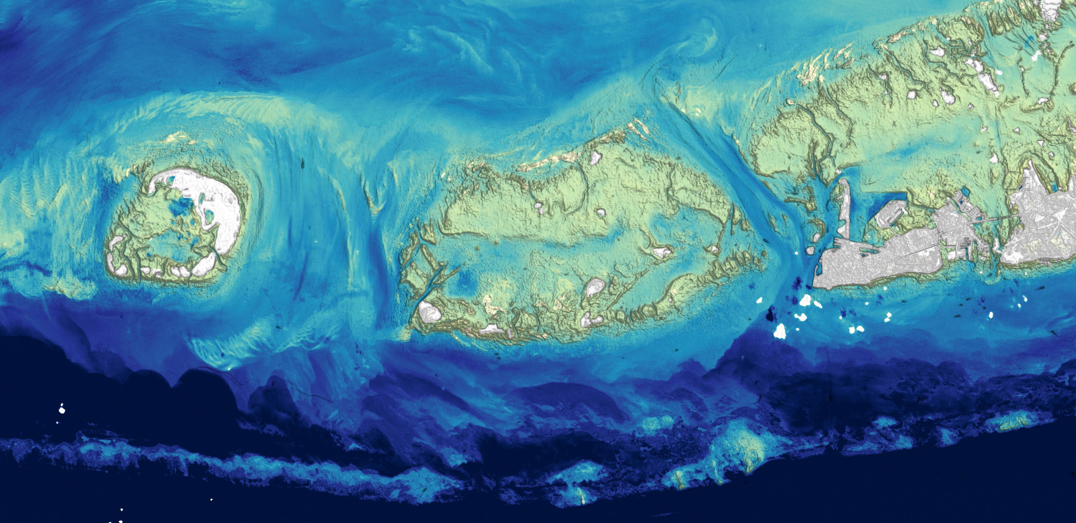
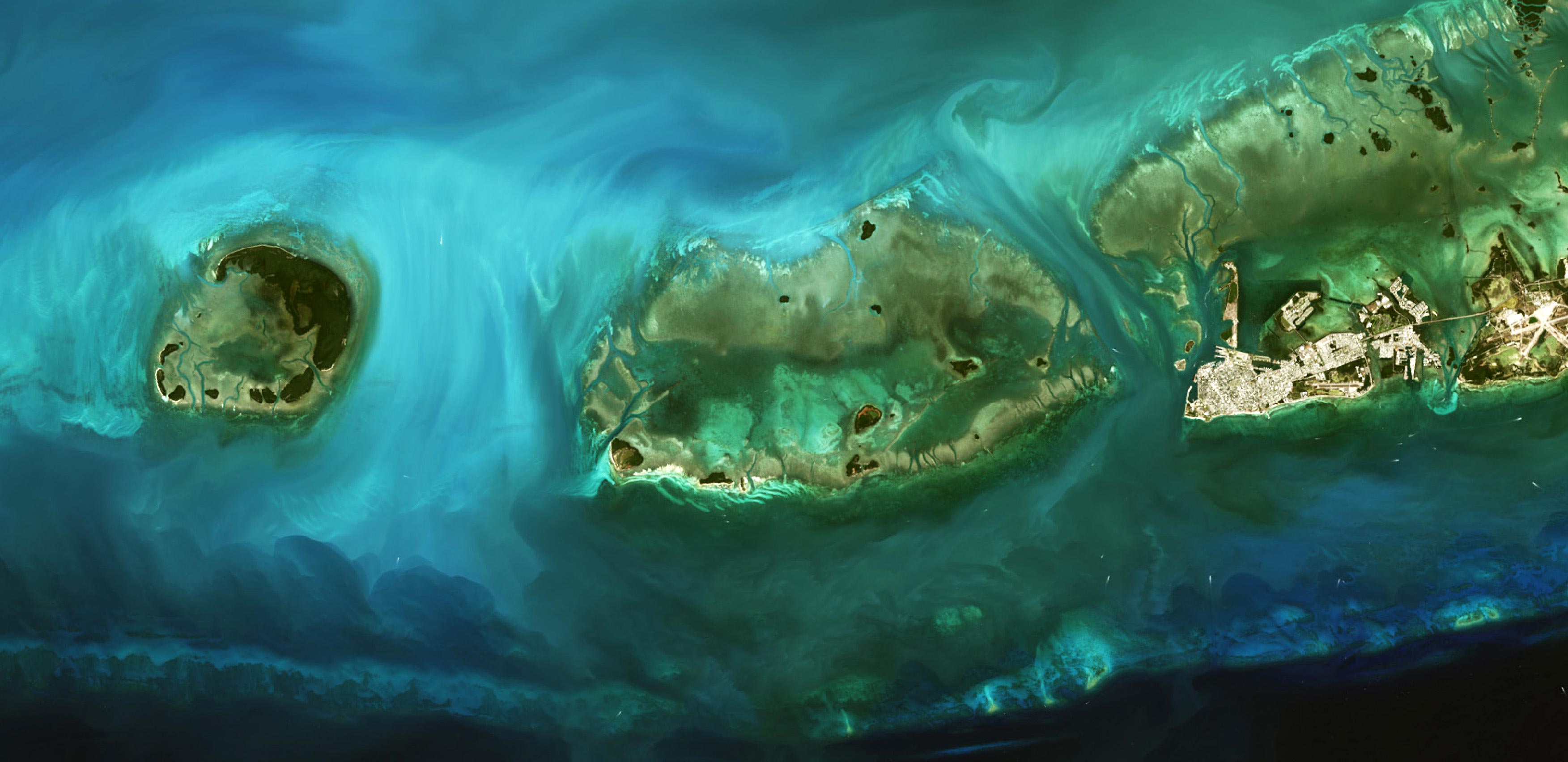
This algorithm was applied to several coastal areas containing coral reefs, including the Florida Keys, shown here. The depth map (upper) shows shallow channels cutting between low-lying islands, also called cays or keys. The shallow linear feature running across the bottom of the image is part of Florida’s stretch of coral reefs, which spans 350 miles (560 kilometers) from end to end. The bathymetric map is shown relative to a natural-color Landsat image of the same area (lower).
Going Deeper: Unexpected Mapping Depths
In clear water, it is possible to map depths greater than 20 meters (65 feet), much deeper than expected, said Minsu Kim, the remote sensing and ocean optics expert who led the method’s development. Crucially, the method works without external calibration, although it can be refined by incorporating bathymetry measurements from other sources. The tradeoff is that the model accounts for the optical properties of common ocean components, such as phytoplankton and suspended solids in the water column, and grass or sand on the seafloor. If uncommon components such as a bloom of a specific phytoplankton species or a rare kind of dark volcanic sea floor are present, the model becomes less accurate.
Coral reef zones were good candidates for piloting this method because they influence sediment transport, affect coastal erosion, and provide critical habitat to much of the world’s marine life, said physical geographer Jeff Danielson, co-author of the paper and leader of the USGS Coastal National Elevation Database (CoNED) Applications Project. These environments can also change dramatically over time and would benefit from more frequent re-mapping made possible by satellite-derived bathymetry.
Overcoming Traditional Mapping Challenges
Despite the need for refined shallow-water maps, however, producing them has remained a practical and technical challenge. Bathymetric mapping has traditionally relied upon ship-based sonar and aircraft-based lidar—both cost- and labor-intensive endeavors.
The quest to outsource this onus to satellites includes a pioneering effort by oceanographer Jacques Cousteau. In the 1975 NASA-Cousteau Bathymetry Experiment, Cousteau and a team of divers aboard the Calypso played leapfrog with the Landsat 1 and 2 satellites around the Bahamas and Florida. They would position themselves directly underneath each day’s satellite pass, and divers would measure water clarity, light transmission, and bottom reflectivity. Data from the trip showed that in clear waters with a bright seafloor, Landsat could measure depths up to 22 meters (72 feet).
The cross-purposing of remote sensing instruments for bathymetry has continued from there. Subsequent techniques have included using turbidity as imaged by Landsat as a proxy for depth; combining altimetry measurements from NASA’s ICESat-2 (Ice, Cloud, and land Elevation Satellite-2) with ship-based sonar; deriving depth from stereo imagery; and applying an algorithm to digital photography from the International Space Station.
Advancing Nearshore Mapping with New Techniques
With the new satellite-based method in hand, Kim, Danielson, and colleagues are looking to scale up nearshore measurements. For example, they want to map waters around Pacific islands and atolls, where data is currently lacking but would be useful for modeling waves, sediment transport, and other processes. Maps are also blank for large portions of coastal Alaska, where hazards including harsh weather, seasonal sea ice, and strong currents have made conventional mapping work difficult.
In the United States alone, coastal waters are currently only 52 percent mapped, Danielson noted. Initiatives such as the National Ocean Mapping, Exploration, and Characterization (NOMEC) and the global Seabed 2030 project are working to increase mapping coverage, alongside the USGS’s CoNED pursuit to assimilate data that now includes Landsat-derived water depth. “It’s one of the hot topics in geospatial sciences right now,” said Danielson. “There is a niche to fill in bathymetry gaps with a new tier of data.”
NASA Earth Observatory images by Wanmei Liang, using Landsat data from the U.S. Geological Survey and data from Kim, M., et al. (2024).
Never miss a breakthrough: Join the SciTechDaily newsletter.
Follow us on Google and Google News.
2 Comments
Given that satellites operate in space, it’s not really surprising that they map anything “without getting wet”
You should note in your article that Landsat satellites are owned and operated by the USG Geological Survey (USGS) which is part of the Department of The Interior.