
Close Menu
    Facebook X (Twitter) Instagram
    SciTechDaily
    • Biology
    • Chemistry
    • Earth
    • Health
    • Physics
    • Science
    • Space
    • Technology
    Facebook X (Twitter) Pinterest YouTube RSS
    SciTechDaily
    Home»Earth»NASA ICESat Shows Himalayan Glaciers Have Lost Less Ice Than Worst Estimates
    Earth

    NASA ICESat Shows Himalayan Glaciers Have Lost Less Ice Than Worst Estimates

    By SciTechDailyAugust 28, 2012No Comments3 Mins Read
    Facebook Twitter Pinterest Telegram LinkedIn WhatsApp Email Reddit
    Share
    Facebook Twitter LinkedIn Pinterest Telegram Email Reddit
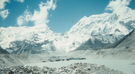
    Lake-Imja-Tsho-1997-himalaya-melt
    Imja Tsho, also known as Imja Lake, formed in the 1950s when meltwater started accumulating at the base of the Imja Glacier, creating a glacial lake.

    A 2010 study using measurements taken by the Gravity Recovery and Climate Experiment (GRACE) satellite reported that glaciers in the Himalayas and the Tibetan plateau were shedding about 50 gigatonnes of ice per year. These results were refuted two years later by a research group using the same data but varied the interpretation to show that the ice loss was only a tenth of that amount.

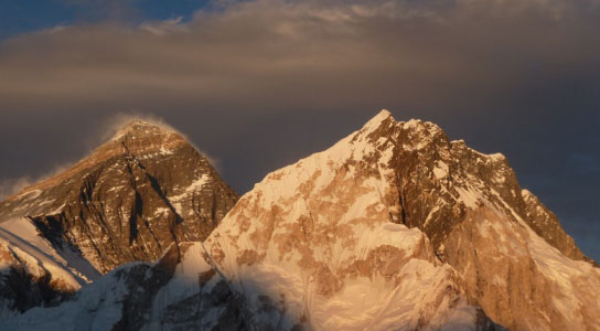
    A new study of the Himalayan glaciers using NASA’s ICESat indicates that these glaciers were losing on average 12 gigatonnes of ice a year between 2003 and 2008. The researchers published their findings in the journal Nature.
    himalayan glaciers

    This new estimate raises even more questions about the reliability of satellite and field measurements of alpine glaciers. ICESat shows twice as much ice loss as the reinterpreted GRACE data, this figure is still three times lower than regional losses estimated on field studies.

    ICESat was launched by NASA in 2003 to track the overall changes in polar ice sheets by measuring their surface elevation with a laser altimeter. It’s designed for smooth topography on the polar regions, and cannot be easily used to map the rough terrains of the Himalayas, states Andreas Kääb, a remote-sensing expert at the University of Oslo in Norway who led the latest study.

    The team tried to solve this problem by correcting the ICESat data using elevation measurements taken from the Shuttle Radar Topography Mission. Kääb et al. also checked the altitude of adjacent terrain, which shouldn’t change drastically over a short period of time, to ensure that the changes in elevation detected by ICESat in the glaciers were genuine.

    Once these were in place, ICESat was used to map the region at a resolution of up to 70 meters (230 feet). Between 2003 and 2008, Himalayan glaciers thinned at a rate of 21 cm (8 in) a year on average, significantly less than the global average for glaciers and ice caps.

    This average can be misleading because it conceals large glacier losses in some parts of the Himalayas, which are balanced out by smaller gains in others. Several discrepancies with other satellite studies and regional-scale assessments remain. Studies like this do not indicate a general climate trend, since in order to make such a conclusion, data would need to be collected across several decades.

    Reference: “Contrasting patterns of early twenty-first-century glacier mass change in the Himalayas” by Andreas Kääb, Etienne Berthier, Christopher Nuth, Julie Gardelle and Yves Arnaud, 22 August 2012, Nature.
    DOI: 10.1038/nature11324

    Never miss a breakthrough: Join the SciTechDaily newsletter.
    Follow us on Google and Google News.

    Environment Glaciology Global Warming Himalayas Popular
    Share. Facebook Twitter Pinterest LinkedIn Email Reddit

    Related Articles

    Greenland Ice Sheet Already Reached Tipping Point 20 Years Ago

    Climate Scientists Sound the Alarm: Warming Greenland Ice Sheet Passes Point of No Return

    Global Methane Emissions Soar to Record High, Even As Pandemic Has Reduced Carbon Emissions

    New Research Shows Greenland Ice Sheet Movement is Decreasing Despite Warming

    Arctic Sea Ice Set for a Record Breaking Melt

    Satellites Confirm Extensive Ice Sheet Melt in Greenland

    Global Warming Impacts Lake Water

    1930s Photos Reveal History of Greenland Glaciers

    Third Pole Glacial Measuring Stations Will Give Monitor Glacier Health in Tibet

    Leave A Reply Cancel Reply

    • Facebook
    • Twitter
    • Pinterest
    • YouTube

    Don't Miss a Discovery

    Subscribe for the Latest in Science & Tech!

    Trending News

    These Toads Are Surviving a Deadly Fungus – Scientists May Finally Know Why

    These Brain Cells May Explain Why We Eventually Have To Sleep

    Tomatoes Contain an Invisible Ingredient With Surprising Effects on Liver Health

    World’s First Heat-Powered Cooling System Turns Waste Heat Into Cold

    Antarctica Gained a Record 695 Billion Tons of Ice in Just Two Years

    Don’t Miss: A Brilliant Venus and Glowing Harvest Moon Light Up the Sky

    New Twist on the Einstein Problem Reveals Unexpected Physics

    JWST Captures Stunning Evidence of How Supermassive Black Holes Feed

    Follow SciTechDaily
    • Facebook
    • Twitter
    • YouTube
    • Pinterest
    • Newsletter
    • RSS
    SciTech News
    • Biology News
    • Chemistry News
    • Earth News
    • Health News
    • Physics News
    • Science News
    • Space News
    • Technology News
    Recent Posts
    • Scientists Discover a Hidden Defect That Could Explain Why IBD Keeps Coming Back
    • Millions Take Blood Pressure Drugs, but Many May Be Missing Their Heart-Protective Benefits
    • Could Alien Life Be Conscious in Ways We Can’t Imagine?
    • Scientists Develop a Fruit Wash That Removes Pesticide Residues and Keeps Produce Fresh Longer
    • Scientists May Have Finally Explained Why Astronauts Get Constipated in Space
    Copyright © 1998 - 2026 SciTechDaily. All Rights Reserved.
    • Science News
    • About
    • Contact
    • Editorial Board
    • Privacy Policy
    • Terms of Use

    Type above and press Enter to search. Press Esc to cancel.