
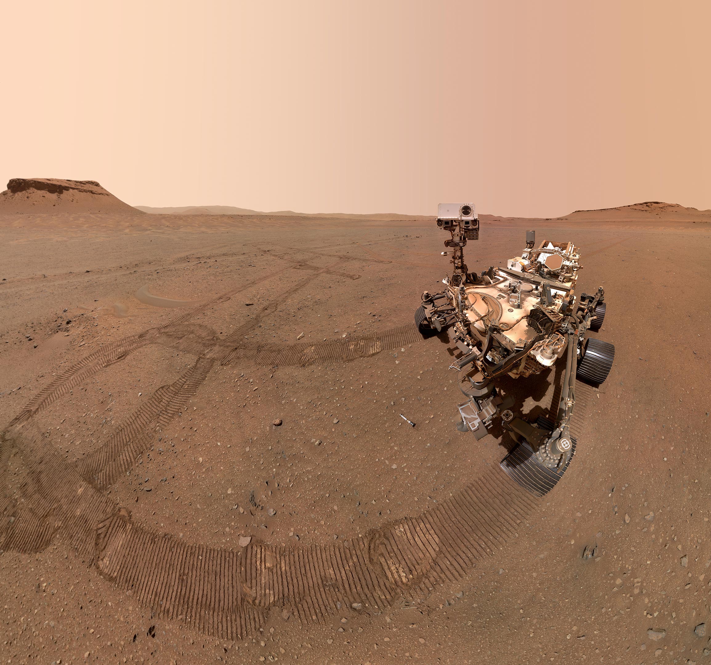
NASA’s Perseverance rover has delivered one of its sharpest panoramas yet, revealing sweeping Martian vistas from the “Falbreen” site.
Taken under unusually clear skies, the mosaic captures distant hills, geologic boundaries, and a mysterious rock perched on a sand ripple. Scientists are intrigued by the site’s ancient terrain, possibly older than Jezero Crater itself, and are studying rock samples and mineral contrasts to piece together Mars’ deep history.
Capturing Mars in Stunning Detail
NASA’s Perseverance rover team recently made the most of unusually clear weather on Mars to produce one of the most detailed panoramic views of the mission so far. The sweeping mosaic, assembled from 96 individual images taken at a site known to the science team as “Falbreen,” showcases a striking range of features.
These include a rock seemingly perched atop a sand ripple, a distinct dividing line between two different types of terrain, and distant hills nearly 40 miles (65 kilometers) away. In an enhanced-color version, the Martian sky appears unusually clear and a surprising shade of blue, while the natural-color image shows it in its familiar reddish tone.
“Our bold push for human space exploration will send astronauts back to the Moon,” said Sean Duffy, acting NASA administrator. “Stunning vistas like that of Falbreen, captured by our Perseverance rover, are just a glimpse of what we’ll soon witness with our own eyes. NASA’s groundbreaking missions, starting with Artemis, will propel our unstoppable journey to take human space exploration to the Martian surface. NASA is continuing to get bolder and stronger.”

Clear Skies and Enhanced Views
The Mastcam-Z camera system recorded the images on May 26, 2025, during the rover’s 1,516th Martian day, or sol, since landing in February 2021 inside Jezero Crater. Perseverance reached the top of the crater rim toward the end of last year.
“The relatively dust-free skies provide a clear view of the surrounding terrain,” said Jim Bell, Mastcam-Z’s principal investigator at Arizona State University in Tempe. “And in this particular mosaic, we have enhanced the color contrast, which accentuates the differences in the terrain and sky.”
The Mystery of the “Float Rock”
One detail that caught the science team’s attention is a large rock that appears to sit atop a dark, crescent-shaped sand ripple to the right of the mosaic’s center, about 14 feet (4.4 meters) from the rover. Geologists call this type of rock a “float rock” because it was more than likely formed someplace else and transported to its current location. Whether this one arrived by a landslide, water, or wind is unknown, but the science team suspects it got here before the sand ripple formed.
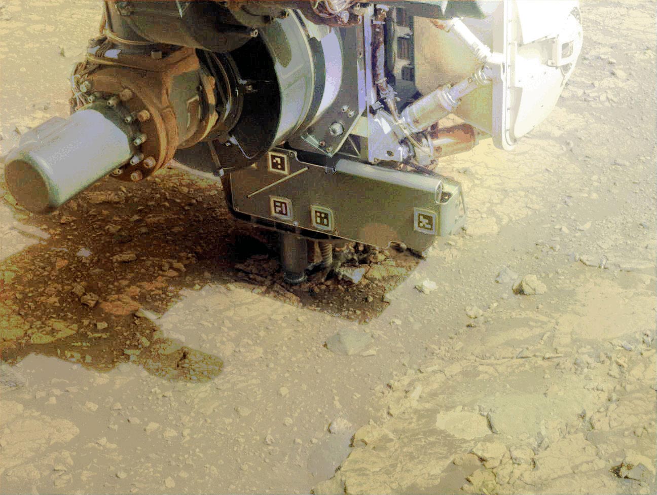
Investigating Ancient Terrain
The bright white circle just left of center and near the bottom of the image is an abrasion patch. This is the 43rd rock Perseverance has abraded since it landed on Mars. Two inches (5 centimeters) wide, the shallow patch is made with the rover’s drill and enables the science team to see what’s beneath the weathered, dusty surface of a rock before deciding to drill a core sample that would be stored in one of the mission’s titanium sample tubes.
The rover made this abrasion on May 22 and performed proximity science (a detailed analysis of Martian rocks and soil) with its arm-mounted instruments two days later. The science team wanted to learn about Falbreen because it’s situated within what may be some of the oldest terrain Perseverance has ever explored — perhaps even older than Jezero Crater.
Tracking the Rover’s Journey
Tracks from the rover’s journey to the location can be seen toward the mosaic’s right edge. About 300 feet (90 meters) away, they veer to the left, disappearing from sight at a previous geologic stop the science team calls “Kenmore.”
A little more than halfway up the mosaic, sweeping from one edge to the other, is the transition from lighter-toned to darker-toned rocks. This is the boundary line, or contact, between two geologic units. The flat, lighter-colored rocks nearer to the rover are rich in the mineral olivine, while the darker rocks farther away are believed to be much older clay-bearing rocks.
More About Perseverance
NASA’s Perseverance rover is a flagship mission within the agency’s Mars Exploration Program, designed to search for signs of ancient life, collect rock and soil samples, and pave the way for future human exploration. Built and operated by NASA’s Jet Propulsion Laboratory — managed for the agency by Caltech — Perseverance is part of the Science Mission Directorate’s efforts to advance planetary science and exploration. Among its advanced instruments is Mastcam-Z, a powerful zoomable camera system that captures high-resolution, color, and 3D images of the Martian surface. Arizona State University leads Mastcam-Z operations in collaboration with Malin Space Science Systems in San Diego, which partnered on the design, fabrication, testing, and ongoing operation of the cameras. This combined expertise enables Perseverance to document Mars’ terrain in unprecedented detail while conducting groundbreaking scientific investigations.
Never miss a breakthrough: Join the SciTechDaily newsletter.
Follow us on Google and Google News.
5 Comments
Stunning depth of field amazing pictures of Mars terrain. Mars is closer
neighbor similar to Earth southwest terrain. Im convinced these images from a planet so close to earth. I always believe their is life beyond our solar system.
Why does Mars have a blue sky if it has no or little atmosphere? Or is this another’s shot of Devon Island, Canada?
Check the captions under the images.
Are you sure this isn’t isn’t Arizona? I can see an asphalt road in the picture.
Read the article. It’s a sand bar.