Europe’s tallest sand dune isn’t just a stunning natural landmark—it’s a living, shifting landscape sculpted by wind and time.
La Grande Dune du Pilat, towering above the French Atlantic coast, migrates inland each year as breezes push grains of sand up its gentle seaward slope and down its steep forest-facing side. Layers of ancient soil reveal a story of climate change, while efforts to stabilize the dune with forests have left their own mark. Just inland, fire-scarred pine woodlands and the diverse wetlands of Arcachon Bay complete this ever-evolving coastal scene.
The Tallest Dune in Europe
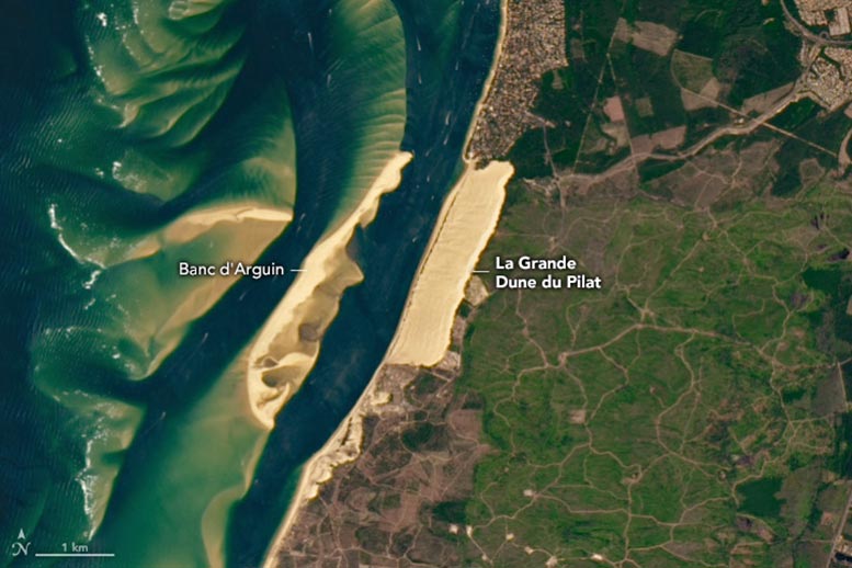
Shaped over time by shifting climates and constant winds, La Grande Dune du Pilat rises more than 100 meters (330 feet) above France’s Atlantic coast. Located southwest of Bordeaux, it holds the title of Europe’s tallest sand dune.
Stretching about 2.7 kilometers (1.7 miles) along the shoreline and extending 0.5 kilometers (0.3 miles) inland, this massive dune is a striking feature of the coastal landscape. Its sweeping form was captured on July 8, 2024, by the Operational Land Imager (OLI) aboard NASA’s Landsat 8 satellite.
Wind-Driven Migration and Dune Movement
Though it may look like a frozen formation, the dune is constantly on the move. Driven by wind, it shifts inland by 4 to 5 meters (13 to 16 feet) each year. Onshore breezes push sand up the dune’s gradual seaward slope, where it collects near the top. From there, the sand often cascades down the steeper inland side, slopes that can reach angles as steep as 29 degrees.
Fluctuations in environmental conditions over thousands of years made the dune what it is today. Scientists think that sand accumulated during periods of cooler, drier conditions. Forests developed in several warmer and wetter stretches, which helped stabilize loose material and enabled the dune to grow higher. The sandy mass is interspersed with several layers of paleosols, or ancient soils, that have helped scientists decode its history. Traces of these dark layers often surface on the dune’s slopes.

Forests, Fire, and Ecosystem Impact
The forest inland of the sandy coastline contains maritime pines, introduced at the turn of the 19th century to try to stabilize the dune, as well as English oaks, which can live up to 1,000 years. In July 2022, a wildfire burned through more than 6,000 hectares (23 square miles) of this forest, although the burned area is not apparent in this 2024 image.
Arcachon Bay: A Coastal Habitat Hotspot
The dune is situated near the entrance to Bassin d’Arcachon (Arcachon Bay), an estuary interrupting a long sandy stretch of beach along France’s southwest coast. The series of channels and sandbanks at the mouth of the bay, including the expansive Banc d’Arguin, are the product of a dynamic tidal environment. Within the semi-enclosed lagoon, salt marshes provide habitat for diverse plant and animal life, and the appropriately named Île aux Oiseaux—Bird Island—is utilized by 150 avian species throughout the year.
NASA Earth Observatory images by Wanmei Liang, using Landsat data from the U.S. Geological Survey.
Never miss a breakthrough: Join the SciTechDaily newsletter.
Follow us on Google and Google News.