Measuring the precise quantity of rainfall in a particular area is straightforward when there is equipment specifically designed to accurately capture and relay precipitation data. However, quantifying and identifying the types of precipitation across all locations on Earth presents significant logistical challenges.
Importantly, this information could provide a wealth of data for characterizing and predicting Earth’s water, energy, and biogeochemical cycles. Researchers from China recently deployed a satellite, FengYun 3G (FY-3G), that is successfully collecting Earth precipitation data from space.
The FY-3G Satellite Mission
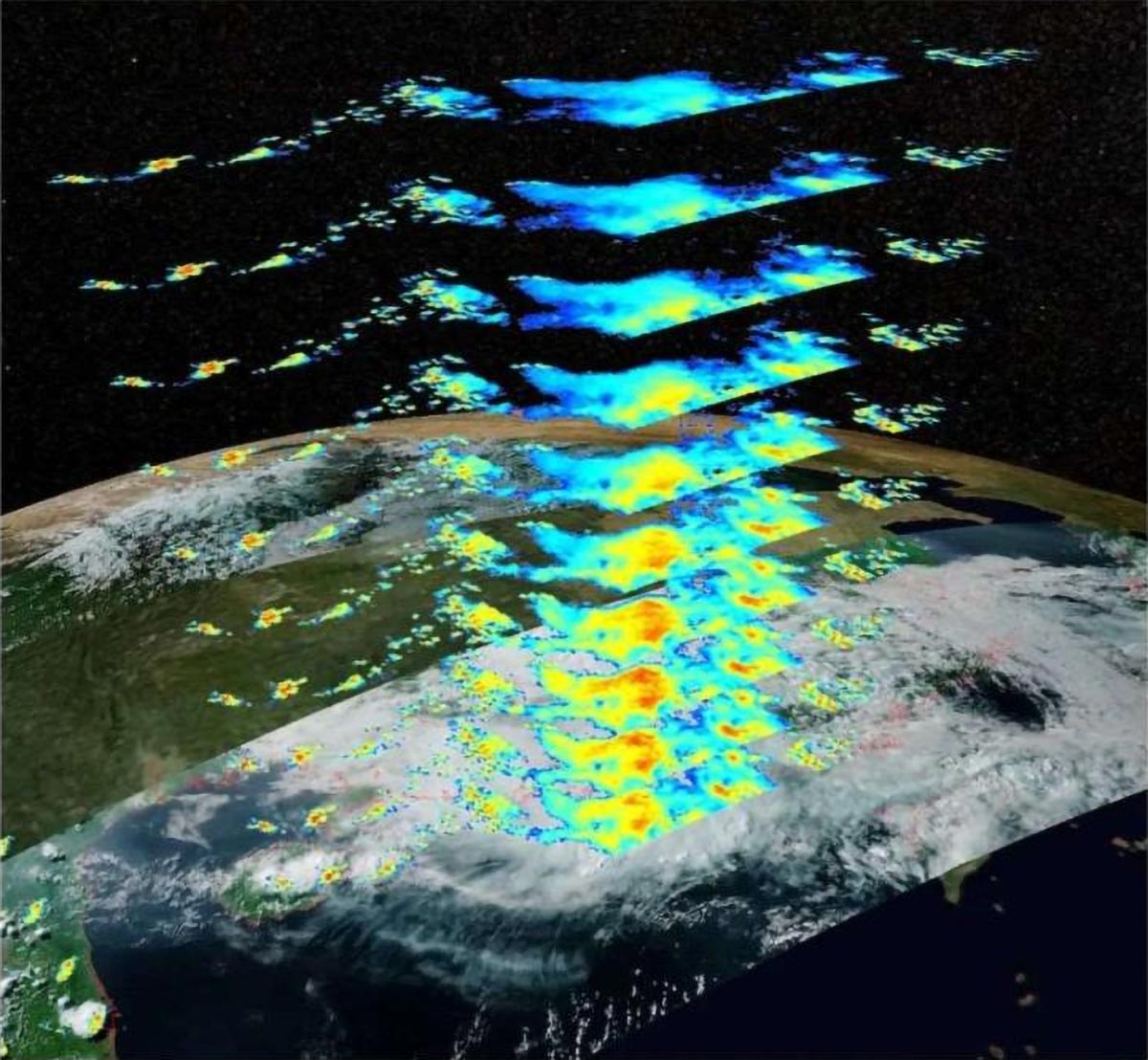
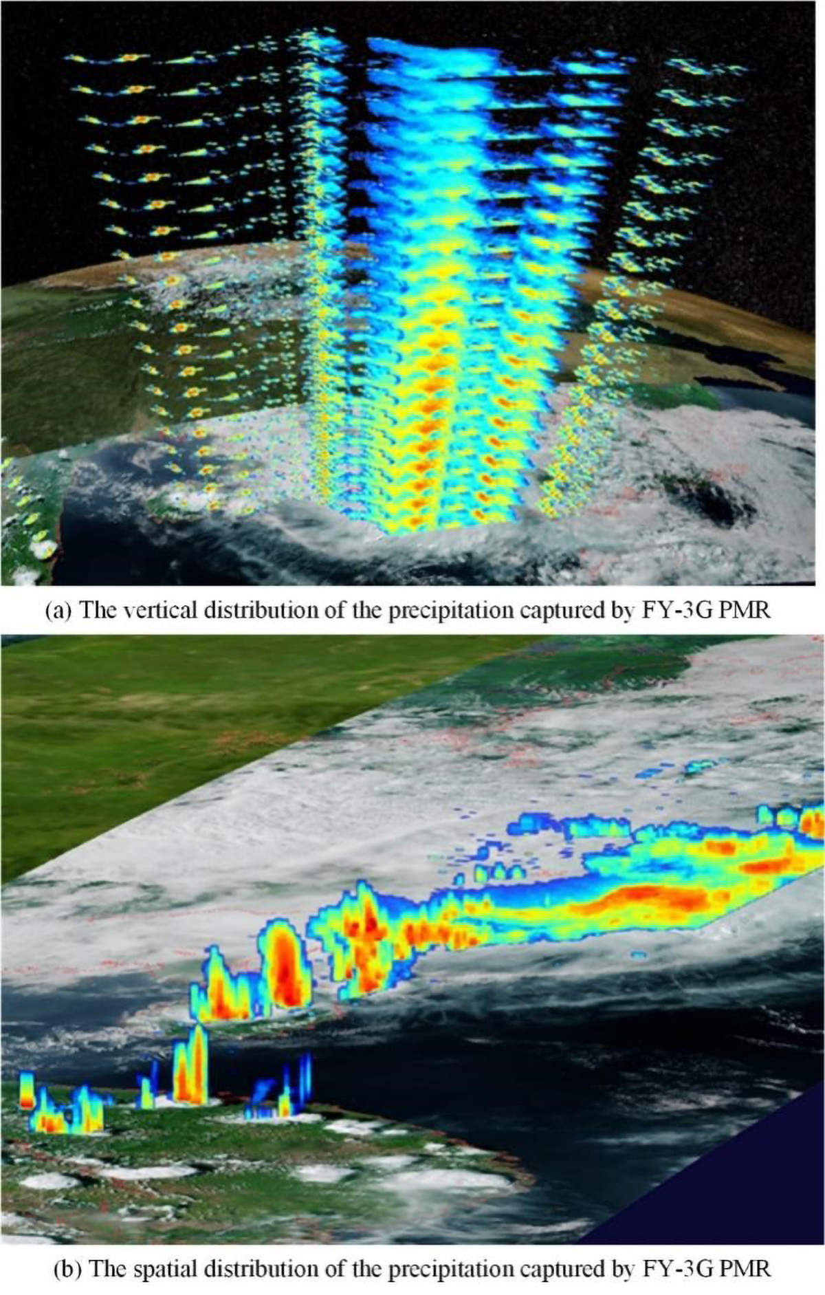
Scientists from the China Meteorological Administration developed and launched a satellite created to measure Earth precipitation with radar while orbiting in space. This is the first of two precipitation missions planned by the team to accurately measure the occurrence, type, and intensity of any precipitation across the world, including over oceans and complex terrain. Specifically, the FY-3G satellite is designed to assess the 3-dimensional (3D) form of rainfall and other precipitation for weather systems at Earth’s middle and lower latitudes.
The team published their results in the Journal of Remote Sensing.
“The first active precipitation measurement satellite in China (FY-3G) was developed and successfully launched, and the commission test of the satellite platform and the instruments [was] completed, illustrating excellent performance. The active and passive microwave instruments combined with optical imaging instruments… obtain high-precision observation data of global precipitation. The satellite can also cooperate with the on-orbit Global Position Measurement (GPM) satellite to enhance the ability of scientists to study the structure and mechanism of global precipitation as well as carry out water cycle research,” said Peng Zhang, first author of the review paper and leading scientist of the FY-3 polar orbiting meteorological satellite program at the National Satellite Meteorological Center in Beijing, China.
Technical Capabilities and Global Impact
FY-3G marks the first rainfall satellite mission from China and the third such mission in the world. The satellite can measure clouds, precipitation, and atmospheric profiles with the complement of remote sensing instruments built into the satellite.
Specifically, the active remote sensing precipitation measurement radar (PMR) works in tandem with a passive microwave imager MWRI-RM, which has been optimized to improve the detection of weaker precipitation over land and solid forms of precipitation. An optical imaging instrument, the MERSI-RM, assists other microwave instruments in measuring clouds and precipitation to facilitate low-orbit precipitation measurement and high-orbit infrared precipitation estimation.
The GNOS-II instrument, also included on the satellite, uses variations in global navigation satellite system (GNSS) data to accurately measure temperature, humidity, and sea surface speed from space. The FY-3G also houses a short-wave infrared polarized multi-angle imager (PMAI) and high radiometric accuracy on-board calibrator (HAOC).
As a precipitation measurement device, the primary instrument of the FY-3G satellite is the active precipitation measurement radar PMR, which creates a 3D rendering of falling precipitation. Data collected by the instrument can then be used to calculate precipitation intensity and type, improving the accuracy of measurements taken from space.
“China has successfully launched a precipitation measurement satellite [FY-3G], and the commission test results show that its measurement performance is superior, and high-precision 3D precipitation measurement information can be obtained. FY-3G and GPM can form a virtual constellation in orbit, which greatly enhances the ability to measure and study global precipitation. FY-3G global observation data are [freely available] to… worldwide users through the Fengyun Satellite Data Center,” said Zhang.
Importantly, FY-3G has improved our understanding of global precipitation, which will help scientists better interpret and predict our planet’s water and energy cycles. This data will be used to enhance forecasting of extreme weather events and inform the development of the program’s next-generation precipitation satellite, FY-5.
Future Developments
The team is encouraged by the data they have received from FY-3G, but more data processing work is required to fully grasp the satellite’s capacity and future applications. “Next, we will accelerate the development of a precipitation event database and precipitation data set based on FY-3G satellite data. We also plan to improve the quantitative inversion accuracy of active radar precipitation and strengthen the global data service of the FY-3G satellite. We will also continue to promote the follow-up satellite development plan to ensure continuous precipitation observation,” said Zhang.
Reference: “FY-3G Satellite Instruments and Precipitation Products: First Report of China’s Fengyun Rainfall Mission In-Orbit” by Peng Zhang, Songyan Gu, Lin Chen, Jian Shang, Manyun Lin, Aijun Zhu, Honggang Yin, Qiong Wu, Yixuan Shou, Fenglin Sun, Hanlie Xu, Guanglin Yang, Haofei Wang, Lu Li, HongWei Zhang, Sijie Chen and Naimeng Lu, 19 December 2023, Journal of Remote Sensing.
DOI: 10.34133/remotesensing.0097
Other contributors include Songyan Gu, Lin Chen, Jian Shang, Manyun Lin, Aijun Zhu, Honggang Yin, Qiong Wu, Yixuan Shou, Fenglin Sun, Hanlie Xu, Guanglin Yang, Haofei Wang, Lu Li, Sijie Chen and Naimeng Lu from the Key Laboratory of Radiometric Calibration and Validation for Environmental Satellites at the National Satellite Meteorological Center (National Center for Space Weather) from the China Meteorological Administration in Beijing, China and the Innovation Center for FengYun Meteorological Satellite in Beijing, China; and HongWei Zhang from the Shanghai Academy of Spaceflight Technology in Shanghai, China.
This work was supported by the FY3-03 meteorological satellite project ground application system and the International Space Water Cycle Observation Constellation Program (grant no. 183311KYSB20200015).
Never miss a breakthrough: Join the SciTechDaily newsletter.
Follow us on Google and Google News.