A warm, moisture-laden weather system soaked western Washington and Oregon.
A powerful atmospheric river streamed toward the U.S. Pacific Northwest in early December 2023. The long current of water vapor delivered warm, wet weather to much of western Washington and Oregon, toppling daily rainfall and temperature records and escalating flood and debris flow risks.
Monitoring Atmospheric Conditions
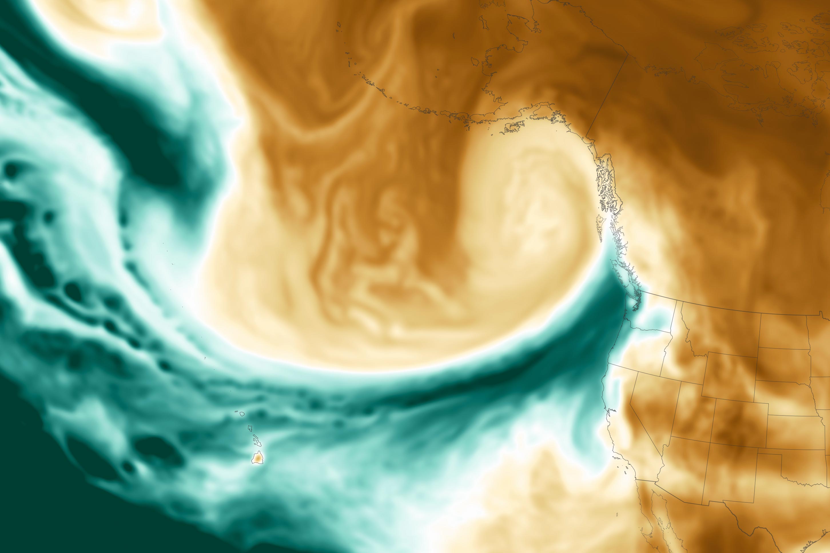
This map shows the total precipitable water vapor in the atmosphere at 1:30 p.m. Pacific Time on December 4. Precipitable water vapor is the amount of water in a column of the atmosphere if all of the water vapor were condensed into liquid. The dark green areas on the map highlight the band of moist air flowing northeast from the tropical Pacific. The image was derived from NASA’s GEOS ADAS (Goddard Earth Observing System, Atmospheric Data Assimilation System), which uses satellite data and models of physical processes to calculate what is happening in the atmosphere.
Impact on Terrain and Weather Records
As the storm encountered land, water vapor was pushed upward over the terrain where it cooled, condensed, and fell mostly as rain. Most of the storm’s precipitation fell between the Pacific coast and the crest of the Cascade Mountains. Some mountainous areas in Washington state were expected to receive 5–9 inches (130–230 millimeters) of water in a 36-hour period ending on the afternoon of December 5.
Meanwhile, in the lowlands, Seattle set a daily rainfall record for December 4 of 1.51 inches (38.3 millimeters), according to news reports. Heavier rains shifted toward northwest Oregon on December 5, with 2–6 inches forecast to fall in the Coast Range that day. Flood watches were issued as rivers swelled.
Record-Breaking Temperatures and Water Supply Relief
Both Portland and Seattle registered new high temperature records during the storm. Portland topped out at 65 degrees Fahrenheit (18 degrees Celsius) on December 4, setting a record for that date and tying the December all-time high temperature record. Seattle hit 59°F (15°C) in the early hours of December 5, topping that date’s previous record of 58°F (14°C) from 2020. Warm temperatures throughout the region exacerbated flood risks, melting mountain snow that had fallen in preceding days.
The rain should help relieve pressure on regional water supplies. In the Seattle area, an unusually dry summer sparked concerns about sufficient water for municipal supplies as well as fish habitat. Atmospheric rivers occur regularly in wintertime and can account for up to 50 percent of all rain and snow that falls in the western United States.
NASA Earth Observatory image by Lauren Dauphin, using GEOS-5 data from the Global Modeling and Assimilation Office at NASA GSFC.
Never miss a breakthrough: Join the SciTechDaily newsletter.
Follow us on Google and Google News.