The Arctic and North Atlantic oceans have seen an increasing number of days when precipitation falls as rain, not snow.
The Arctic is known for its cold temperatures, which allow precipitation to fall as snow. But as temperatures warm, that snow is being replaced by rain. These changes can affect sea ice in the Arctic and weather patterns throughout the Northern Hemisphere.
NASA scientists examined rainfall trends over the Arctic and North Atlantic oceans from 1980 to 2016 and found an increase in the frequency of rainy days. They also found that the length of the annual rainy season grew longer. The results were published in the Journal of Climate.
Increasing Rainfall Trends and Arctic Warming
The most dramatic changes took place in the North Atlantic, where it rained on average five more days per decade at the end of the 36-year study period than at the beginning. The rest of the study region—the central Arctic Ocean and its peripheral seas—saw an average of two additional rainy days per decade. This comes as temperatures in the Arctic are warming four times faster than the rest of the planet.
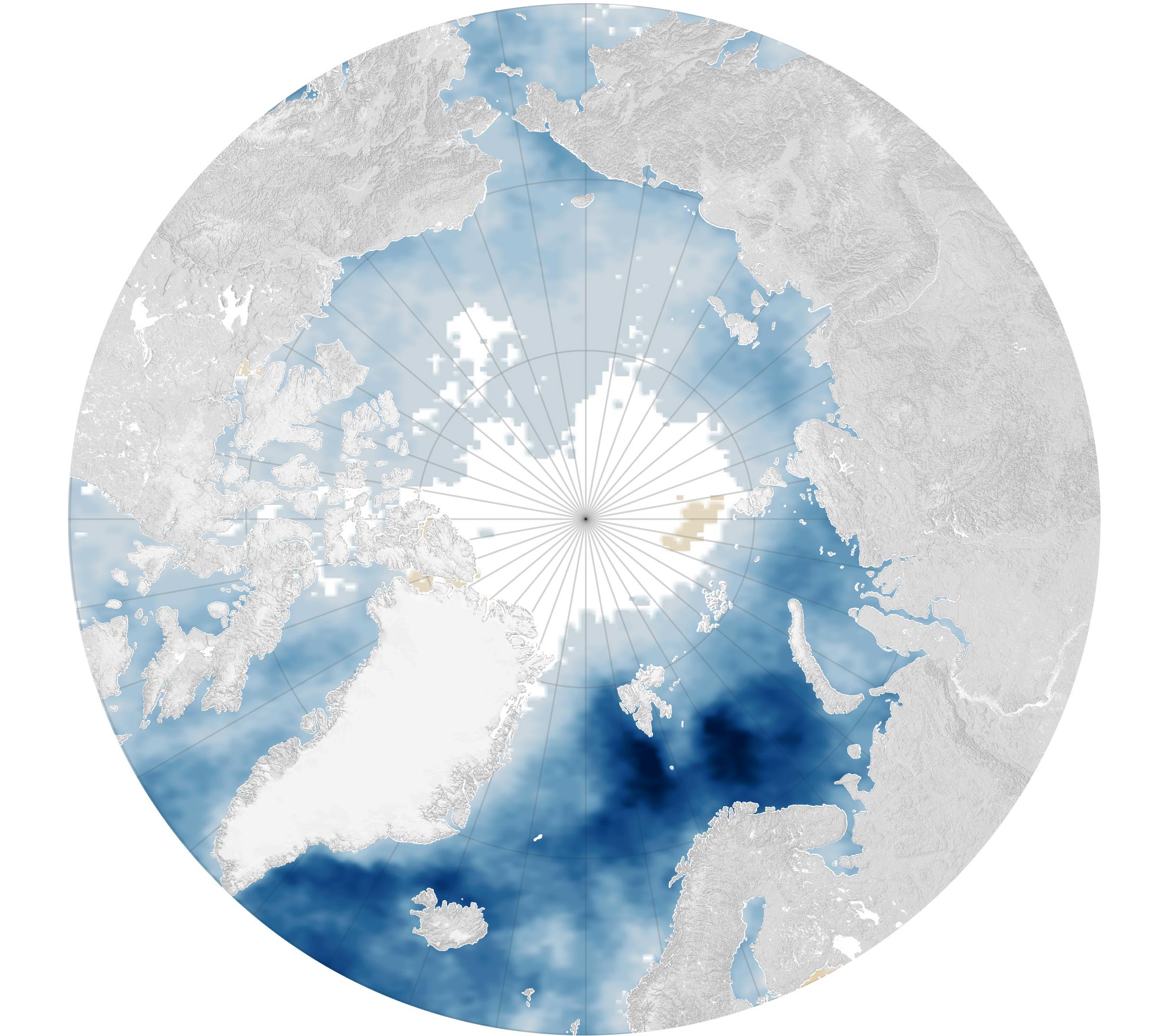
The map above shows the change in number of rainy days per year, which has contributed to this decadal trend toward a rainier Arctic. It is based on the Modern-Era Retrospective analysis for Research and Applications, Version 2 (MERRA-2), a global reanalysis product developed by NASA’s Global Modeling and Assimilation Office. The product takes in-situ and satellite observations, including from NASA’s Atmospheric Infrared Sounder (AIRS) on the Aqua satellite, and uses them to reproduce conditions that have occurred across the globe.
Here, much of the North Atlantic is shown in deep blue, which indicates a larger increase in the number of rainy days per year (between 1980 and 2016) compared with light blue areas. The Barents Sea north of Norway and the Kara Sea north of Siberia are also shown in deep blue.
“One thing to note is that there really is no dark brown anywhere, so in no way are we seeing any significant decreases in the number of rainfall days,” said Chelsea Parker, a weather and climate scientist at NASA’s Goddard Space Flight Center and co-author of the study.
When temperatures are above freezing, clouds are more likely to contain liquid that drops as rain than ice that falls as snow, said Linette Boisvert, a cryospheric scientist at NASA Goddard and lead author of the study.
Impacts of Rainfall on Arctic Ice and Global Weather
When rainfall hits the snow-covered sea ice, it darkens the surface and can amplify melting that in turn leads to more warming—a process known as the ice-albedo feedback loop. Snow on top of sea ice acts as insulation, reflecting solar radiation back to space and keeping the surface cool. Rain eats away at this snowy buffer.
“If it rains during the sunlit months, the surface is going to be a lot darker because the snow is wet compared to a fresh, dry, and thick snowpack. This wet snow surface is going to start absorbing more of that incoming solar radiation,” Boisvert said. When the snow melts, it forms ponds on the ice, creating a darker surface and absorbing more solar radiation. This sets off a loop of continued warming and melting.
Meanwhile, water vapor drives its own feedback loop. The atmosphere can hold more water vapor as temperatures rise. As a heat-trapping greenhouse gas, this water vapor warms the Earth’s surface and contributes to melting the snow and ice. This melting exposes open ocean, allowing evaporation to take place, which releases more water vapor into the atmosphere.
Feedback loops in the Arctic impact other parts of the world, too. Changes to the amount of heat in the Arctic can influence weather patterns farther south. For example, Parker pointed to extreme temperature swings in the U.S. and polar air masses that form over the North Pole and move south over North America.
“All of that,” Parker said, “is dependent on the extent to which the Arctic is experiencing climate change.”
Reference: “Rainy Days in the Arctic” by Linette N. Boisvert, Melinda A. Webster, Chelsea L. Parker and Richard M. Forbes, 8 September 2023, Journal of Climate.
DOI: 10.1175/JCLI-D-22-0428.1
NASA Earth Observatory image by Wanmei Liang, using data from Boisvert, L., et al. (2023).
Never miss a breakthrough: Join the SciTechDaily newsletter.
Follow us on Google and Google News.
3 Comments
“… Arctic’s Surprising Rain SURGE”
Is an average increase of 0.2 to 0.5 days per year statistically significant? Is it physically important?
“When rainfall hits the snow-covered sea ice, it darkens the surface and can amplify melting that in turn leads to more warming—a process known as the ice-albedo feedback loop.”
The thing is, the surface looks darker because water does not reflect diffusely, instead reflecting specularly, meaning that reflected light is confined to a sheaf of rays that are not generally visible. One has to be looking in the direction of the sun and at approximately the angle of incidence of the sun’s light rays. It is not unlike driving on wet pavement. Driving into the sun in early morning or late afternoon, the specular reflection is blinding; however, driving away, or looking at right angles, the asphalt pavement looks dark. The so-called ‘ice-albedo feedback loop’ is exaggerated because when the sun is low on the horizon (And it NEVER gets overhead in the Arctic, even during the Summer Solstice!) the specular reflectance can exceed the albedo of the snow — it just can’t be observed as readily. They need to step away from their computers and look outside at the real world.
https://wattsupwiththat.com/2016/09/12/why-albedo-is-the-wrong-measure-of-reflectivity-for-modeling-climate/
“The atmosphere can hold more water vapor as temperatures rise.”
That is true, but it doesn’t mean that it WILL. For the air to be saturated with water vapor, as it commonly is in the tropics, there has to be a ready source of water vapor either from evaporation, sublimation, or transpiration. There is little water available from transpiration in the Arctic, and sublimation doesn’t play a significant role unless it is very windy. Evaporation will similarly be low if there is a lot of ice cover. The Arctic is essentially a cold desert, and probably the reason it is warming so much is precisely because the water vapor is so sparse that the CO2 spectral absorption features aren’t saturated.
https://scitechdaily.com/desert-paradox-dry-regions-defy-climate-change-moisture-predictions/