
Using fault geometry data, scientists simulated the Noto Peninsula earthquake and explained why uplift varied so drastically by location.
On New Year’s Day 2024, a powerful 7.5-magnitude earthquake struck the Noto Peninsula in north central Japan, causing widespread damage due to ground uplift, when the Earth’s surface rises as a result of tectonic plate movement.
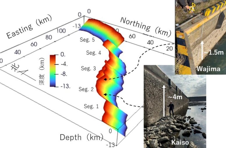
The degree of uplift varied greatly across the region, with some locations experiencing up to a 5-meter (16.4 feet) rise. To better understand how the properties of fault lines influence earthquake behavior, researchers in Japan used newly developed simulations to create a detailed model of the fault. Their findings may support the creation of more accurate earthquake scenarios and contribute to future disaster risk reduction.
The results were published in the journal Earth, Planets and Space as a Frontier Letter.
Building a realistic fault model
“During the Noto Peninsula earthquake, we saw devastating uplift in some areas compared to others. In this study, we set out to understand the mechanism controlling the magnitude and spatial and temporal variation of fault slip and the resulting ground surface uplift,” said Ryosuke Ando, an associate professor in the Graduate School of Science at the University of Tokyo and lead author of the study.
The researchers aimed to develop a simulation model of the 2024 earthquake based on prior studies and data collected before the event. This included fault characteristics and records of seismic activity leading up to the quake. By accurately reproducing the earthquake with a model based on real-world fault features, they hoped to reveal how fault geometry, which includes the fault’s shape, orientation, angles (known as dip and strike), and direction of motion (slip)—affects earthquake dynamics.
Fault geometry and earthquake behavior
There are three major faults involved in the 2024 Noto Peninsula earthquake. They are what are known as conjugate faults, i.e., faults with opposite senses of lateral movement. Two of them (the Monzen Fault, marked as Seg. 1 in the figures, and the Noto Peninsula Hoku-gan Fault Zones, Segs. 2-4) are southeast dipping, while the third (the Toyama Trough Sei-en Fault, Seg. 5) is northwest dipping.
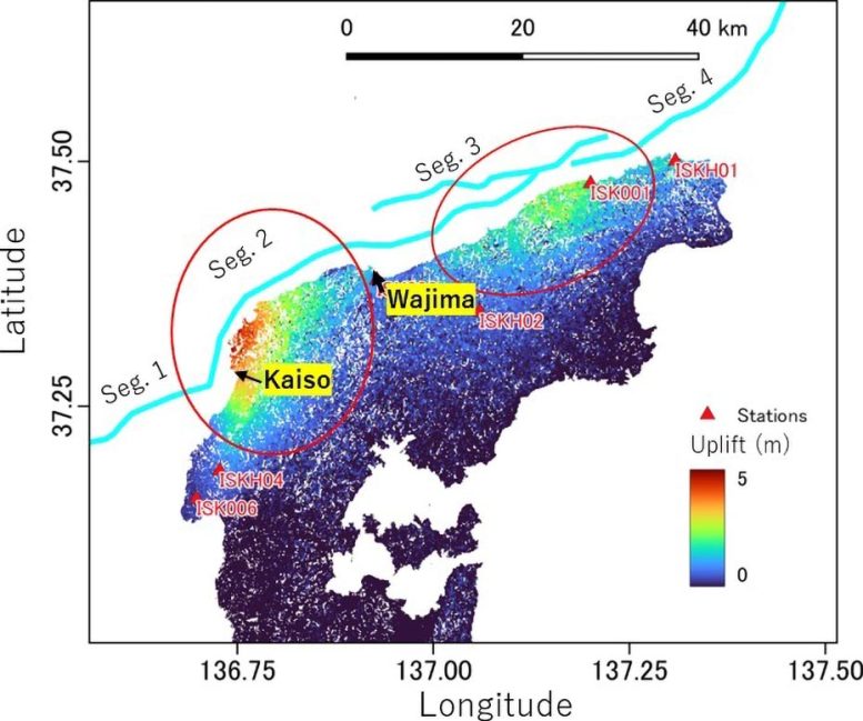
Dipping refers to the direction of the fault’s incline. Observational data on fault traces (where faults intersect with the Earth’s surface) and the fault dipping angle were used to build the 3D fault geometry model. Data from previous seismic activity were used to establish the model of stress conditions. This area was subject to a localized, concentrated seismic swarm of smaller, shallower quakes for years leading up to the 2024 earthquake.
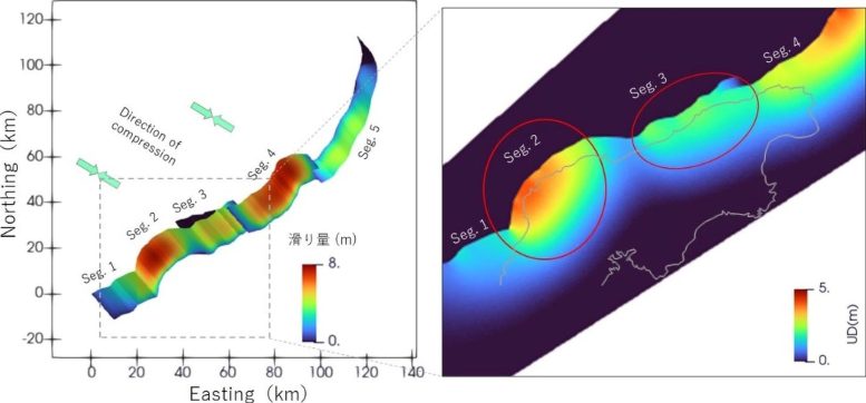
The simulation, developed with observational data of the fault geometry, was able to reproduce the variation in uplift that occurred during the 2024 Noto Peninsula earthquake. In some areas, uplift caused significant damage, while in others the effect was not as severe due to less prominent uplift.
Based on the model of the Noto quake, vertical displacement was concentrated near the fault traces where the fault locally deviates from its overall horizontal orientation. This points to the fault geometry being key to how the earthquake affects the land.
Toward better earthquake prediction
“Our simulation with a supercomputer enabled the analysis of the three-dimensional fault geometry, which is irregularly shaped. We revealed that the fault geometry controlled the overall process through the relative fault orientations to the compressional force acting in the tectonic plate in this region,” said Ando.
Looking ahead, the researchers are considering how this model could be used to develop better dynamic rupture scenarios for future earthquakes. “By demonstrating the potential of simulations with detailed models of fault geometries, we have shown how the characteristics of the fault slip pattern can be constrained before the occurrence of large earthquakes. We expect this finding to lead to building a method to assess the characteristics of hazards caused by future large earthquakes,” said Ando.
Reference: “Nonplanar 3D fault geometry controls the spatiotemporal distributions of slip and uplift: evidence from the Mw 7.5 2024 Noto Peninsula, Japan, Earthquake” by Ryosuke Ando, Yo Fukushima, Keisuke Yoshida and Kazutoshi Imanishi, 29 April 2025, Earth, Planets and Space.
DOI: 10.1186/s40623-025-02187-9
Funding: Japan Society for the Promotion of Science; Ministry of Education, Culture, Sports, Science and Technology; Japan Agency for Marine-Earth Science and Technology
Never miss a breakthrough: Join the SciTechDaily newsletter.
Follow us on Google and Google News.
1 Comment
Global warming?