A wildfire devastated Lahaina, Maui, aided by strong winds and dry weather. Hundreds of structures were damaged, with ongoing search and rescue operations. NASA’s Earth Applied Sciences Disasters program is providing support.
A fast-moving wildfire has devastated the historic town of Lahaina on Maui, Hawaii’s second-largest island.
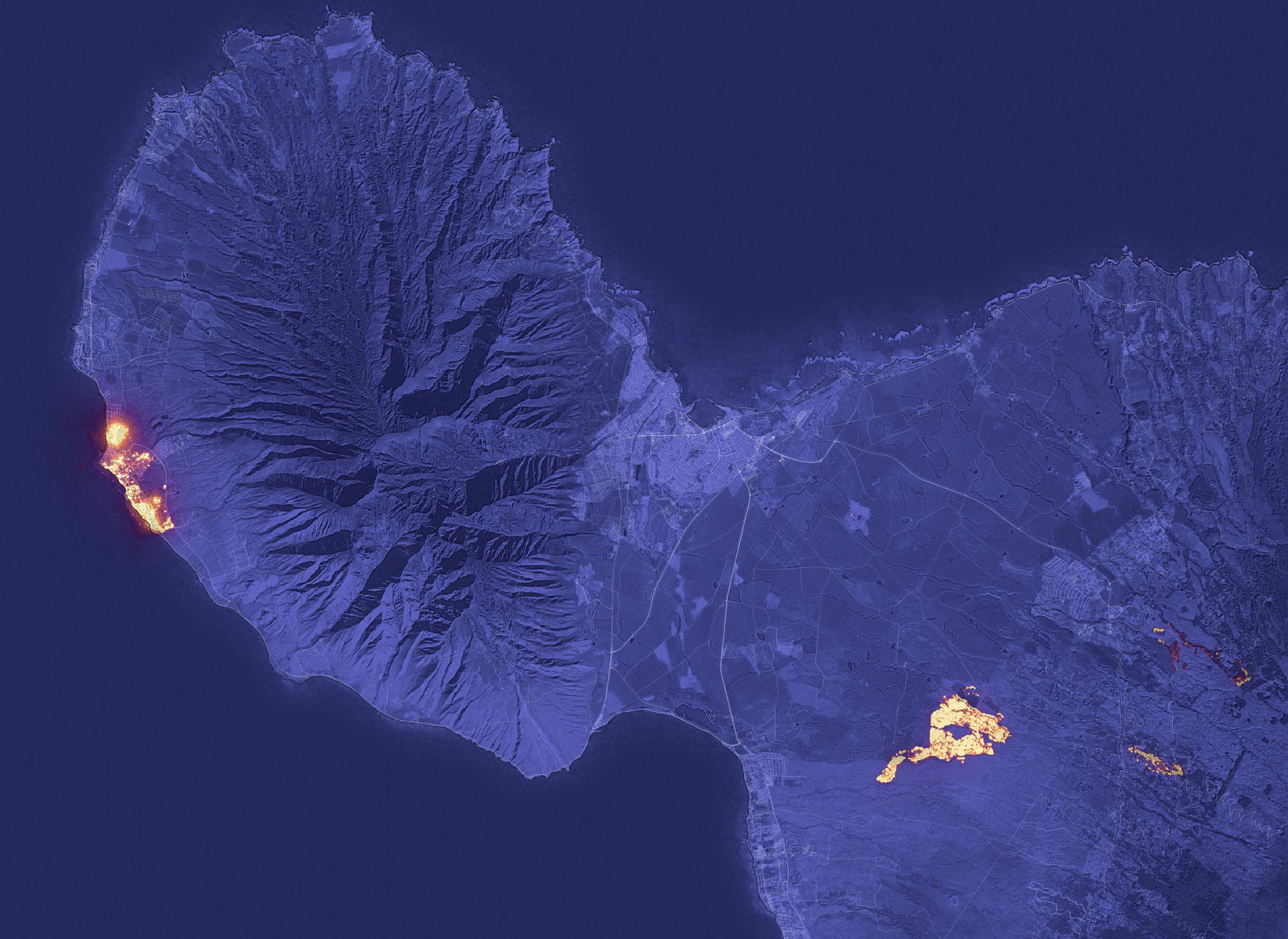
Image Composition and Analysis
The image above shows the signature of the fire at 10:25 p.m. local time on August 8, 2023, as observed by the Operational Land Imager (OLI) on the Landsat 8 satellite. Much of Lahaina, a town with a resident population of nearly 13,000 people, appeared to be on fire at the time of the image. Another large fire burned northwest of Kihei.
The image was composed from OLI observations of shortwave infrared light (band 6). Infrared observations are useful for distinguishing the locations of active fires, shown here in yellow. The shortwave infrared data were overlaid on a natural-color mosaic image based on Landsat 8 observations for added geographic detail.
Weather Conditions Contributing to the Fires
The fires occurred during a period of strong winds and dry conditions in Maui. Between August 7-9, 2023, the island experienced peak gusts that ranged from 45 to 67 miles (72 to 107 kilometers) per hour, according to the National Weather Service. The presence of a strong high-pressure area to north of the island and Hurricane Dora to the south may have helped fuel the winds. An analysis by the U.S. Drought Monitor shows that the southwestern part of the island was in the midst of moderate to severe drought at the time of the fires.
Damage Reports and Rescue Operations
Maui County has reported damage to hundreds of structures, with widespread damage in the Lahaina harbor area. On August 9, authorities were continuing to conduct search and rescue operations.
NASA’s Support for the Incident
NASA’s Earth Applied Sciences Disasters program area has been activated in support of the fires in Hawaii. As new information becomes available, the team will be posting maps and data products on its open-access mapping portal.
NASA Earth Observatory image by Lauren Dauphin, using Landsat data from the U.S. Geological Survey.
Never miss a breakthrough: Join the SciTechDaily newsletter.
Follow us on Google and Google News.
2 Comments
It should be noted from the Landsat image that, just as in Paradise (Calif.), the bulk of the burning is human structures, not the natural landscape. The fire codes obviously need to be upgraded.
A non-government based formal climate attribution study on what caused the high winds on Maui August 8 and 10 is needed, because of the high loss of life. The possibility of high winds was not forseen by any local Hawaii meteorologists for that day. On August 7, 2023, KHON TV in Honolulu predicted Dora would have minimal impact on Hawaii, using data from the Central Pacific Hurricane Center.
‘HONOLULU (KHON2) — Hurricane Dora continues to fluctuate in intensity, but is still on track to pass south of the islands on Tuesday with minimal impact. No heavy rain is expected as Dora passes to the south, however trade winds may become strong in the Monday through Wednesday timeframe with winds up to 35 mph. Here is the latest track and intensity forecast from the Central Pacific Hurricane….. Hurricane-force winds extend outward up to 30 miles (45 km) from the center and tropical-storm-force winds extend outward up to 115 miles (185 km).’, in the article, ‘Hurricane Dora on track to pass south of the Hawaiian Islands’, Aug 7, 2023 / 09:38 PM HST
So KHON TV weather saw hurricane Dora’s winds extending 115 miles from its center, a predicted ‘minimal impact’ factor for Hawaii August 8. Hawaii’s state climatologist, Pao-Shin Chu, said he also was caught off guard by the impact Dora had from roughly 500 miles (800 kilometers) away.
‘ “Hurricane Dora is very far away from Hawaii, but you still have this fire occurrence here. So this is something we didn’t expect to see,” he said.’, in the article, “Flash drought, invasive grasses, winds, hurricane and climate change fuel Maui’s devastating fires”, by Claire Rush, and others, Associated Press, August 9, 2023, 4:39 PM
On the other hand, ‘The National Weather Service noted in a tweet before the fires started that significant differences in atmospheric pressure between the hurricane and the air north of Hawaii formed a pressure gradient over the islands which, when combined with dry conditions, posed a serious threat of fires as well as damaging winds. “While Hurricane Dora passes well south with no direct impacts here, the strong pressure gradient between it & the high pressure to the north creates a threat of damaging winds & fire weather (due to ongoing dry conditions) from early Mon to Wed,” the agency said at the time.’, in the article, ‘How did the Maui fire start? What we know about the Lahaina blaze’, by Emily Mae Czachor, August 14, 2023.
An atmospheric pressure gradient formed ‘over the islands’, partially due to Dora’s low pressure system, at least 500 miles away, and a prevailing high pressure system? How believable is that? Meteorologist Genki Kino with the National Weather Service stated ‘strong trade winds’ were produced because Dora’s low pressure system was exacerbated by the high pressure system over Maui and the Pacific Ocean. See he article, “Flash drought, invasive grasses, winds, hurricane and climate change fuel Maui’s devastating fires”, by Claire Rush and others. Let us call this the National Weather Service hypothesis of the origin of strong winds on Maui on Tuesday August 8, 2023.
“As wind sent fires spreading out of control Tuesday, many meteorologists pointed out that Hawaii found itself between a strong area of high pressure over the North Pacific and Hurricane Dora, a cyclone that rapidly intensified into a major Category 4 storm. That pressure difference meant Hawaii was in the middle of winds flowing intensely from high pressure to low, gusting over the islands like air being released from a balloon at more than 80 mph in some spots.”, in thearticle, ‘Maui fires not just due to climate change but a ‘compound disaster’, by Scott Dance, August 12, 2023 at 9:47 a.m. EDT washingtonpost
Most meteorologists had Dora at least 550 miles from Maui on August 8. Hurricane scientist Philippe Papin tweeted, ‘Dora played a *very* minor role, slightly enhancing low-level flow over Maui at fire initiation time.’, in the article, ‘What caused the deadly Hawai‘i wildfires?’, by Bob Henson and Jeff Masters August 10, 2023 https://yaleclimateconnections.org/2023/08/what-caused-the-deadly-hawaii-wildfires/
Both Henson and Masters seemed to agree with Papin, and went on to write,
“It’s also possible that the record-hot air mass over the U.S. Southwest — whose unprecedented heat has been deemed virtually impossible without human-induced climate change ¬¬— played an indirect role in the Maui fires. Upper-level steering currents around the massive high appear to have pushed a wedge of unusually warm, dry air, extending several miles above ground level, westward all the way to Hawai‘i, as shown in the animation embedded below (the acronym PGF refers to pressure gradient force, which is proportional to the difference in high pressure and low pressure across a given distance). This air mass would have then descended the tall slopes of Maui into areas that ultimately burned.”
This allegedly ‘warm, dry air extending several miles’ associated with the high pressure cell, ‘intensified’ as it descended down the high mountains to Lahaina. Henson and Masters downplaying any direct effect from hurricane Dora on Maui’s high winds. Henson and Masters continued,
“Moreover, its center (Dora’s) took a westward path that stayed more than 700 miles south of the island. Dora’s tropical-storm-force winds extended no more than about 150 miles north of its center, and surface pressures were higher than average across most of the area between the islands and Dora when the fires erupted….. Surface pressures in association with the large, intense high-pressure cell over the central North Pacific were unusually high (denoted by orange and red colors) across most of the region around Hawai‘i except for a small area immediately surrounding compact Hurricane Dora (bottom center, in blue).”
Henson and Masters down played the significance if any, of the low pressure system associated with Dora, in causing Maui high winds August 8. This is the Henson and Masters hypothesis. They concluded, “A formal climate attribution study would help shed light on how much the factors above played into the catastrophic compound disaster across Maui”. A formal climate attribution study would examine whether the winds associated with the high pressure system, that alledgedly descended from the mountains, create the 7 to 10 foot waves seen at Maui August 8? Spectrum News Weather staff, in the article, ‘Dry and windy con¬di¬tions continue to fuel ongoing fires in Hawaii’, 11:30 AM ET Aug. 09, 2023, stated,
“Big swells from Dora will also subside as the storm heads farther west, but some of the eastern-facing shores will still deal with rough surf and large-breaking waves on Wednesday. With wave heights reaching 7 to 10 feet, a High Surf Advisory remains in effect for the eastern shores of Maui, Molokai, Oahu and Kauai through Wednesday evening.”
Where did those 7 foot waves come from on August 8 at Maui? A Dora Hurricane whose general winds and low pressure system was hundreds of miles away? A high pressure system that seemingly whose winds would push the oceanic water away from Lahaina? And why was the surface pressures across most of the Pacific Ocean unusually high August 8? Hopefully those waters hadn’t been lasered. Due to man’s ability to modify weather, and in cases there is substantial loss of life such as in Lahaina , formal climate attribution studies should be mandated by law. In the same manner reports should be created for weather modification activities with the National Oceanic and Atmospheric Administration. https://library.noaa.gov/Collections/Digital-Collections/Weather-Modification-Project-Reports
(a)The following, when conducted as weather modification activities, shall be subject to reporting:
1. Seeding or dispersing of any substance into clouds or fog, to alter drop size distribution, produce ice crystals or coagulation of droplets, alter the development of hail or lightning, or influence in any way the natural development cycle of clouds or their environment;
2. Using fires or heat sources to influence convective circulation or to evaporate fog;
3. Modifying the solar radiation exchange of the earth or clouds, through the release of gases, dusts, liquids, or aerosols into the atmosphere;
4. Modifying the characteristics of land or water surfaces by dusting or treating with powders, liquid sprays, dyes, or other materials;
5. Releasing electrically charged or radioactive particles, or ions, into the atmosphere;
6. Applying shock waves, sonic energy sources, or other explosive or acoustic sources to the atmosphere;
7. Using aircraft propeller downwash, jet wash, or other sources of artificial wind generation; or
8. Using lasers or other sources of electromagnetic radiation.
Man created convective winds that have their origin in local temperature differences, possibly by a blast from space laser into an ocean, or directed energy weapons (DEWS) are regulated by the U.S. government. On August 10, Joe Biden declared Maui a major disaster eligible for federal funds, while high winds were still blowing on Maui, and Dora was 860 miles away. https://www.whitehouse.gov/briefing-room/presidential-actions/2023/08/10/president-joseph-r-biden-jr-approves-hawaii-disaster-declaration-3/
Many times the first fireman on the scene of a fire, may have had their hand in fanning the flames before others arrived. The high winds present and massive rainfall at Burning Man festival in Neveda September 2, the massive wind fanning of wildfires in Greece in August 2023, the torrential floods in Beijing in July 2023, an once in the past one hundred years Hilary hurricane targeting southern California, rare ‘fire tornado’ in Canada reported by CNN, the targeting of specific places by the weather, says this isn’t just climate change, but better non-governmental policing of the weather modifiers is needed.