
Geologists at the University of Miami leveraged World War II aerial photos and modern satellite imagery to study Andros Island’s landscape transformations due to sea level rise over eight decades.
Despite the sea rising approximately 10 centimeters since the 1980s, the shorelines have remained surprisingly stable. However, the inland marshes and mudflats have undergone significant changes, showing a shift in bacterial mats and channel structures, largely driven by rising sea levels rather than hurricane impacts.
Discovery of Historical Photos
When University of Miami geologist Robert Ginsberg passed away in 2017, his colleagues discovered something remarkable among his papers: a collection of black-and-white aerial photographs of the Bahamas. Upon closer examination, they realized these were British Royal Navy reconnaissance photos taken during World War II, including 1943 images of Andros Island, the largest island in the Bahamas.
By comparing these historic photographs with modern Landsat satellite images, scientists gained valuable insights into how rising sea levels have reshaped Andros Island’s inland marshes over the past 80 years. Surprisingly, while the marshes underwent significant changes, the island’s shoreline has remained largely unchanged.
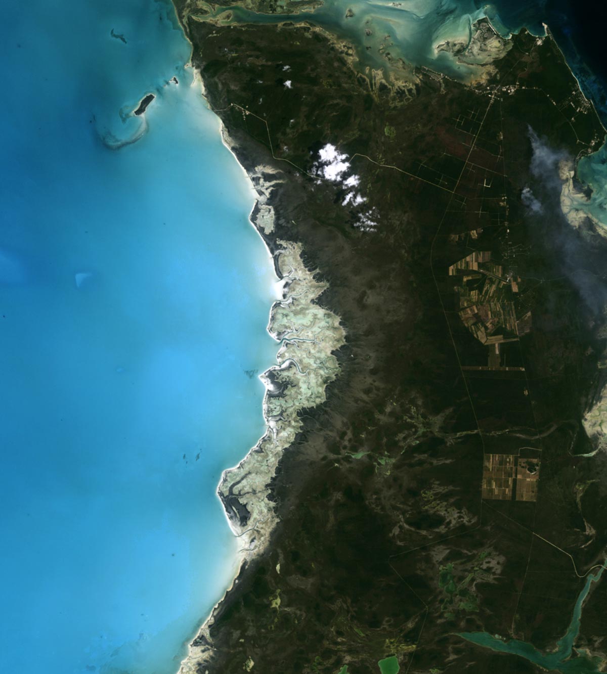
Rising Sea Levels and Stable Shorelines
Data collected by tide gauges indicate that sea level at Andros Island rose by roughly 10 centimeters (4 inches) between 1985 and 2018—at roughly the same rate that global sea level has increased since the 1990s. Research-grade tide gauge data is not available for Andros Island back to the 1940s, but experts calculate sea level in the region has increased by an average of 0.18 centimeters per year since 1950.
“Given the rapid rate of change, we expected to see recession of the coastlines,” said University of Miami geologist Sam Purkis, coauthor of a study in Sedimentary Geology that detailed changes on Andros Island. “But the shoreline was actually quite stable.”

Marshlands: Nature’s Response to Sea Change
Instead, Purkis and his colleagues observed major changes in the inland marshes and mudflats on the western side of the island. In this shallow, sheltered area, carbonate sediment accumulates amid dendritic networks of tidal channels and extensive mats of laminated Scytonema cyanobacteria. These dark brown bacterial mats (close up above) thrive in freshwater at roughly 7 centimeters (3 inches) below the average high water mark, keeping them above most daily tidal fluctuations and making them an excellent marker of sea level.
The pair of Landsat images at the top of the page highlights changes in the distribution of bacterial mats and channels in the shallow tidal zone of the Three Creeks area in the northern part of the island. The TM (Thematic Mapper) on Landsat 5 captured the lower image on the top of this page on April 29, 1986. The OLI-2 (Operational Land Imager-2) on Landsat 9 captured the upper image on May 15, 2024.
The Impact of Environmental Forces
Scytonema mats are dark brown. The bacterial mats are especially widespread in inland marshes, but patches of Scytonema also thrive in higher-elevation areas in the tidal zone atop channel levees in mudflats closer to the shoreline. Carbonate mud is white. Inland vegetation, largely pine forests, appears green. The aerial photograph below, taken by Purkis in 2021, shows a closer view of Scytonema marshes and carbonate mudflats.
“Notice how much the Scytonema mats moved—more than 200 meters (700 feet) inland in some areas—and how much the overall architecture of the channels evolved over the decades,” said Purkis. “We saw a lengthening, widening, and proliferation of channels that was the direct result of sea level rise.”

As part of the analysis, Purkis and coauthor Mingyue Wu considered whether hurricanes might be responsible for the changes. Andros was struck by multiple Category 4 and 5 storms over the study period, but by tracking changes observed by Landsat on a yearly basis the researchers found these storms caused few lasting changes to the structure of mudflats, marshes, or channels on the island.
“One of the lessons from what’s happened on Andros is that the effects of sea level rise are not uniform or intuitive,” said Purkis, noting that the shorelines saw little change because they were adequately replenished with sediment. “As sea level continues to rise,” he said, “people should understand that shorelines might stay in place in some areas, while inland marshes might expand and hollow out islands from the inside.”
NASA Earth Observatory images by Michala Garrison, using Landsat data from the U.S. Geological Survey. Photos courtesy of Sam Purkis (University of Miami) and Gregor Eberili (University of Miami).
Never miss a breakthrough: Join the SciTechDaily newsletter.
Follow us on Google and Google News.