
Close Menu
    Facebook X (Twitter) Instagram
    SciTechDaily
    • Biology
    • Chemistry
    • Earth
    • Health
    • Physics
    • Science
    • Space
    • Technology
    Facebook X (Twitter) Pinterest YouTube RSS
    SciTechDaily
    Home»Earth»Intense Explosions at Mount Semeru – One Year After Unleashing Deadly Eruption
    Earth

    Intense Explosions at Mount Semeru – One Year After Unleashing Deadly Eruption

    By Adam Voiland, NASA Earth ObservatoryDecember 13, 2022No Comments3 Mins Read
    Facebook Twitter Pinterest Telegram LinkedIn WhatsApp Email Reddit
    Share
    Facebook Twitter LinkedIn Pinterest Telegram Email Reddit
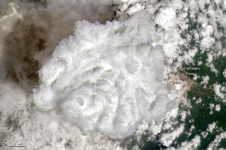
    Mount Semeru December 2022 Annotated
    Landsat 9 Satellite image of Mount Semeru in Indonesia on December 4, 2022.

    Intense explosions at the summit sent avalanches of ash and mud racing down the southeastern flank of the Indonesian volcano.

    In early December 2022, the tallest and most active volcano on Java erupted again, just one year after Indonesia’s Mount Semeru unleashed a destructive, deadly eruption. Late on December 3, a series of explosions from the summit crater expelled gas and ash that, according to the Darwin Volcanic Ash Advisory Center, rose as high as 6,100 meters (20,000 feet) at times. Intense activity continued throughout the night into the next day.

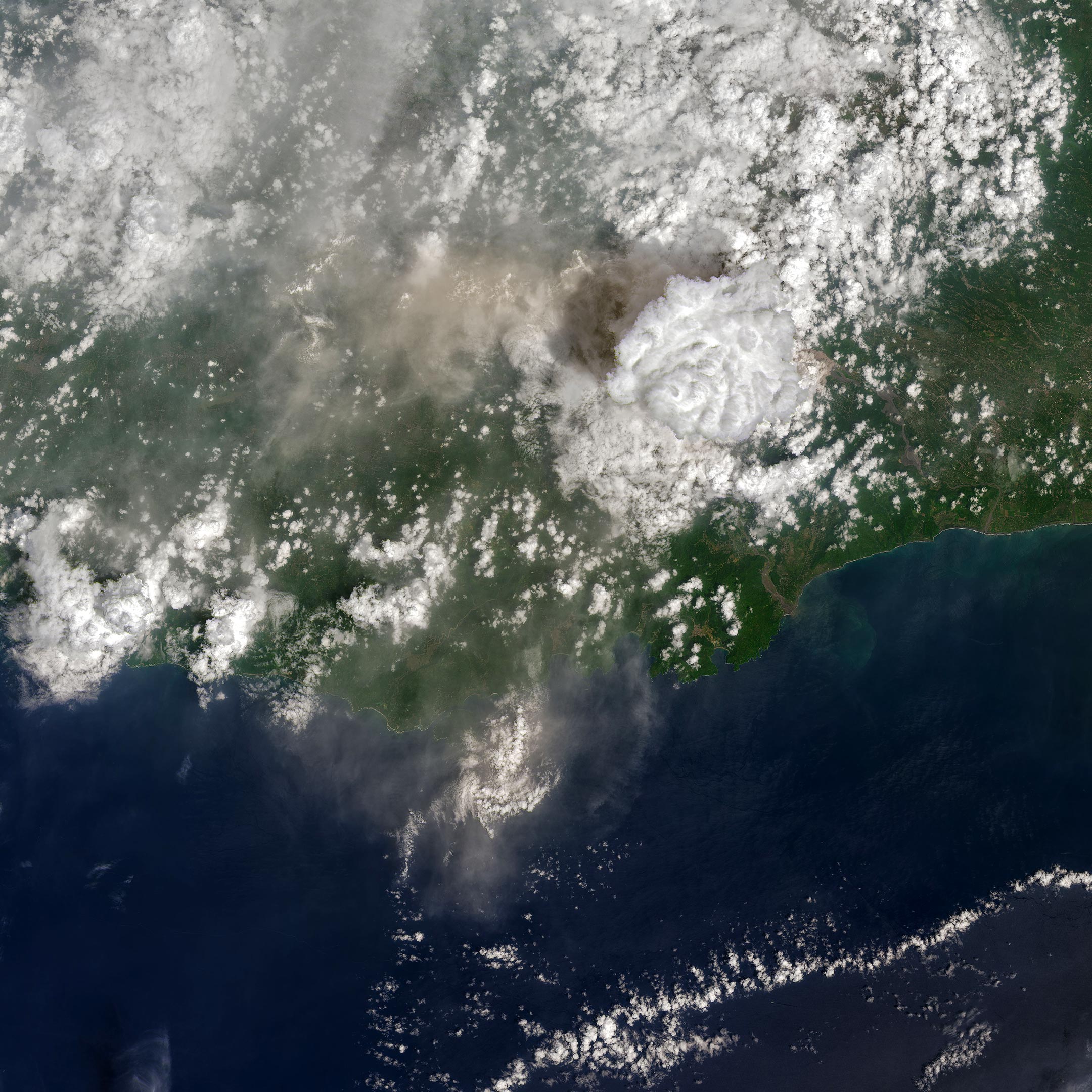
    On December 4, 2022, the Operational Land Imager-2 (OLI-2) on Landsat 9 captured this natural-color satellite image of a volcanic plume streaming from Semeru at about 9:30 a.m. local time (02:30 Universal Time). Volcanic plumes typically consist of ash and a mixture of volcanic gases, including water vapor, carbon dioxide, sulfur dioxide, hydrogen sulfide, and hydrogen halides. In this case, a towering convective cloud, perhaps drawing energy from the heat of the eruption, has obscured parts of the plume. Diffuse ash slightly darkens the large cloud’s shadow (directly to its west) and the underlying landscape farther to the west in this wider version of the image (below).
    Mount Semeru December 2022
    Landsat 9 Satellite image of Mount Semeru in Indonesia on December 4, 2022.

    Below and to the east of the large convective cloud is what appears to be the edge of a pyroclastic flow moving down a river channel on the mountain’s southeastern flank. These billowing avalanches of superheated ash, tephra, soil, and other debris race at high speeds and can destroy most things in their path. The eruption on December 3–4 produced several of these flows, including one that reached a length of 19 kilometers (12 miles), according to the Indonesian National Board for Disaster Management (BNPM).

    Since heavy rains preceded the event, the pyroclastic flows likely mixed with rainwater and morphed into muddy lahars as they rushed down the mountain. The flows destroyed a bridge and buried homes up to their rooftops, according to the Associated Press.

    The eruption has forced nearly 2,000 people from their homes. On December 4, 2022, the Center for Volcanology and Geological Hazard Mitigation (PVMBG) raised the status of the eruption from 3 (“siaga,” or “alert”) to 4 (“awas,” or “caution”), the highest on the 1-4 scale. The PVMBG urged people to stay at least 5 kilometers (3 miles) away from the summit and at least 500 meters (1,600 feet) from the Besuk Kobokan river channel.

    NASA Earth Observatory image by Joshua Stevens, using Landsat data from the U.S. Geological Survey.

    Never miss a breakthrough: Join the SciTechDaily newsletter.
    Follow us on Google and Google News.

    Geography NASA NASA Earth Observatory Volcano
    Share. Facebook Twitter Pinterest LinkedIn Email Reddit

    Related Articles

    Island Obliterated: Dramatic Changes at Hunga Tonga-Hunga Ha’apai

    Hunga Tonga Island Obliterated – NASA Satellites Capture Massive Blast

    A Wolf Awakens in the Galápagos Islands at Night

    A Deadly Day on Mount Semeru: Destructive Rivers of Debris on Indonesian Volcano

    Wall of Lava Burns a Path Through La Palma

    Cumbre Vieja Lights Up the Night – Astronaut Photo Captures Volcanic Eruption From Space

    Socked in Stratovolcano: Astronaut on ISS Captures Incredible View of Uninhabited Atlasov Island

    Kilauea’s Lava Lake Returns – Hawaii’s Most Active Volcano Is Erupting Again

    Newberry Volcano Photographed by Astronaut Onboard the International Space Station

    Leave A Reply Cancel Reply

    • Facebook
    • Twitter
    • Pinterest
    • YouTube

    Don't Miss a Discovery

    Subscribe for the Latest in Science & Tech!

    Trending News

    Black Hole Shredded a Massive Star in the Most Powerful Stellar Explosion Ever Seen

    Building the Brain Requires Millions of Dangerous DNA Breaks

    Endless Supply of Cancer-Fighting Immune Cells Unlocked by USC Scientists

    XRISM Reveals Galaxy-Shaping Winds Erupting From a Supermassive Black Hole

    New Molecule Restores the Brain’s Natural Defenses Against Alzheimer’s

    Could Creatine Boost More Than Muscles? It May Also Help Depression

    Scientists Discover a Natural Molecule That Could Help Prevent Vision Loss

    Scientists Thought Royal Jelly Made Queen Bees. They Were Wrong

    Follow SciTechDaily
    • Facebook
    • Twitter
    • YouTube
    • Pinterest
    • Newsletter
    • RSS
    SciTech News
    • Biology News
    • Chemistry News
    • Earth News
    • Health News
    • Physics News
    • Science News
    • Space News
    • Technology News
    Recent Posts
    • The Strange Force That Could Slow Interstellar Solar Sails
    • Microscope Breakthrough Could Reveal Proteins Once Thought Too Small To See
    • Beyond Heisenberg: Scientists Discover a New “Space-Time Limit” in Quantum Physics
    • New Technique Exposes Hidden Multiple Sclerosis Damage in Routine MRI Scans
    • Intermittent Fasting Benefits May Last Long After the Diet Ends
    Copyright © 1998 - 2026 SciTechDaily. All Rights Reserved.
    • Science News
    • About
    • Contact
    • Editorial Board
    • Privacy Policy
    • Terms of Use

    Type above and press Enter to search. Press Esc to cancel.