A breathtaking astronaut photo reveals El Salvador’s Lake Coatepeque—an ancient volcanic crater lake that sometimes mysteriously turns brilliant turquoise.
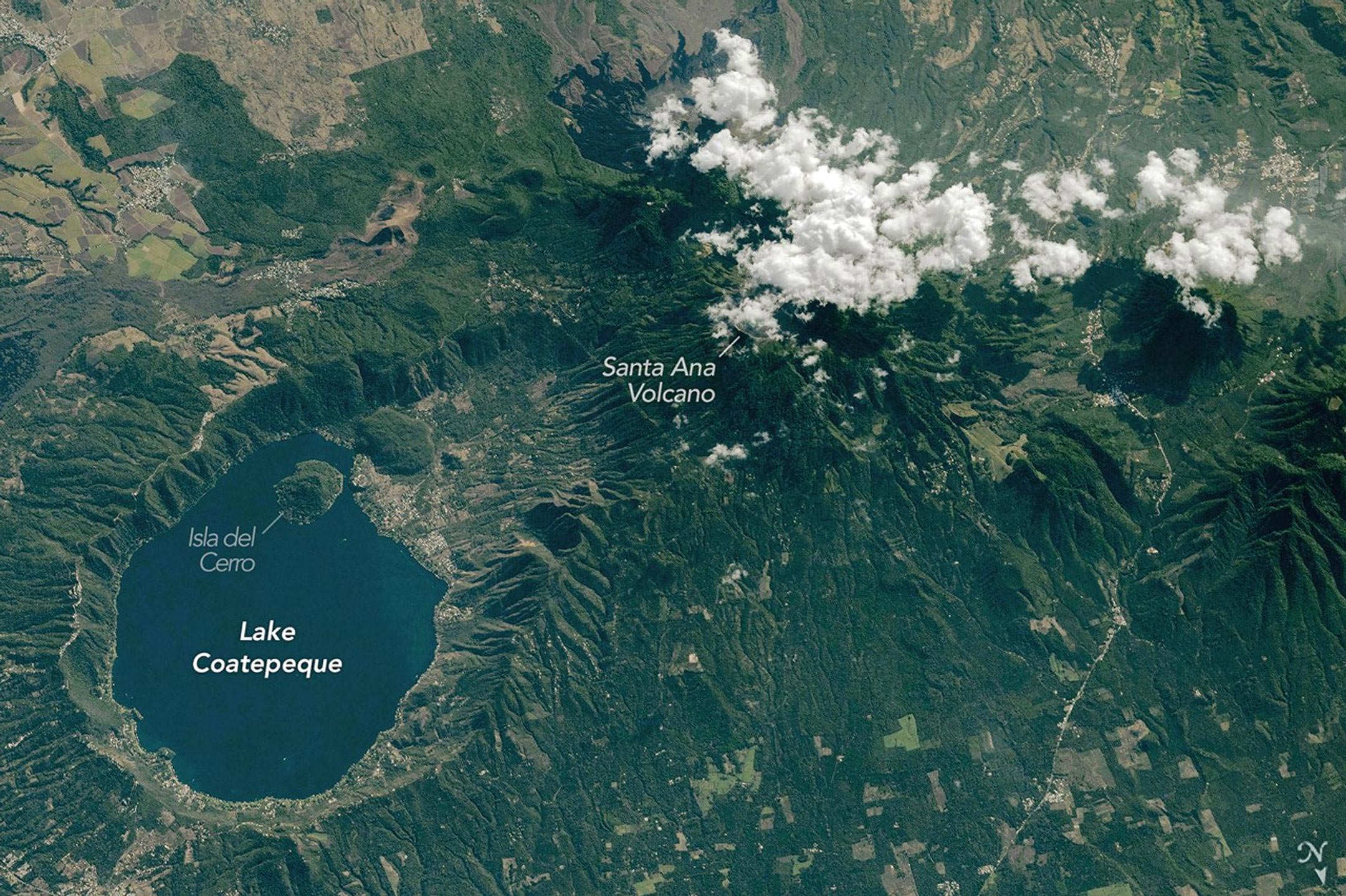
Lake Coatepeque, located just inland from El Salvador’s Pacific coastline, stands out for its vivid blue water that fills part of a volcanic caldera bearing the same name. On February 10, 2026, an astronaut aboard the International Space Station photographed the lake and surrounding terrain as the spacecraft passed over Central America.
Explosive Origins of the Coatepeque Caldera
The caldera that now holds Lake Coatepeque formed during a series of powerful volcanic eruptions between 72,000 and 51,000 years ago. After this massive collapse structure developed, later eruptions created several lava domes along the caldera’s western edge. One of these domes eventually became Isla del Cerro (Isla Teopán), an island that rises from the lake today. According to the Smithsonian Institution’s Global Volcanism Program, no eruptions have been reported from the Coatepeque caldera during the Holocene (the past 11,700 years).
Communities Along the Lakeshore and Nearby Active Volcano
Today the shoreline of Lake Coatepeque is lined with homes, restaurants, boathouses, and other lakeside buildings. Development extends westward toward the steep rim of the caldera, which borders the eastern flank of Santa Ana, the tallest volcano in El Salvador.
Unlike the quiet Coatepeque caldera, Santa Ana remains active. Historical records describe small to moderate explosive eruptions beginning in the 16th century. The volcano’s most recent significant eruption took place in 2005.
Why the Lake Sometimes Turns Turquoise
In the astronaut photograph, Lake Coatepeque appears in its typical deep blue color. However, the lake occasionally changes appearance. At certain times the water shifts to a bright turquoise shade, a phenomenon that has drawn scientific interest.
Researchers reported in 2024 that pigments produced by microalgae and cyanobacteria can influence the lake’s color. Still, they concluded that the dramatic turquoise episodes are most likely caused by natural mineralization processes within the water.
A Landscape Shaped by Volcanoes
The terrain surrounding Lake Coatepeque and Santa Ana Volcano includes a mix of cities, farmland, and additional volcanic features. The city of Santa Ana is located about 15 kilometers (9 miles) north of the lake, while San Salvador lies roughly 40 kilometers (25 miles) to the east. Both cities sit within a region shaped by volcanic activity.
This rugged volcanic terrain extends more than 1,000 kilometers (600 miles) along the Pacific side of Central America, stretching from Guatemala to Panama. The chain of volcanoes that forms this corridor is known as the Central American Volcanic Arc.
Details of the Astronaut Photograph
Astronaut photograph ISS074-E-312810 was taken on February 10, 2026, using a Nikon Z9 digital camera with a focal length of 400 millimeters. The image was provided by the ISS Crew Earth Observations Facility and the Earth Science and Remote Sensing Unit at NASA Johnson Space Center. A member of the Expedition 74 crew captured the photograph.
The images have been cropped and enhanced to improve contrast, and lens artifacts have been removed. The International Space Station Program supports the laboratory as part of the ISS National Lab to help astronauts take pictures of Earth that will be of the greatest value to scientists and the public, and to make those images freely available on the Internet.
Never miss a breakthrough: Join the SciTechDaily newsletter.
Follow us on Google and Google News.