Dubai’s coast has some of the largest and most recognizable land reclamation projects on Earth.
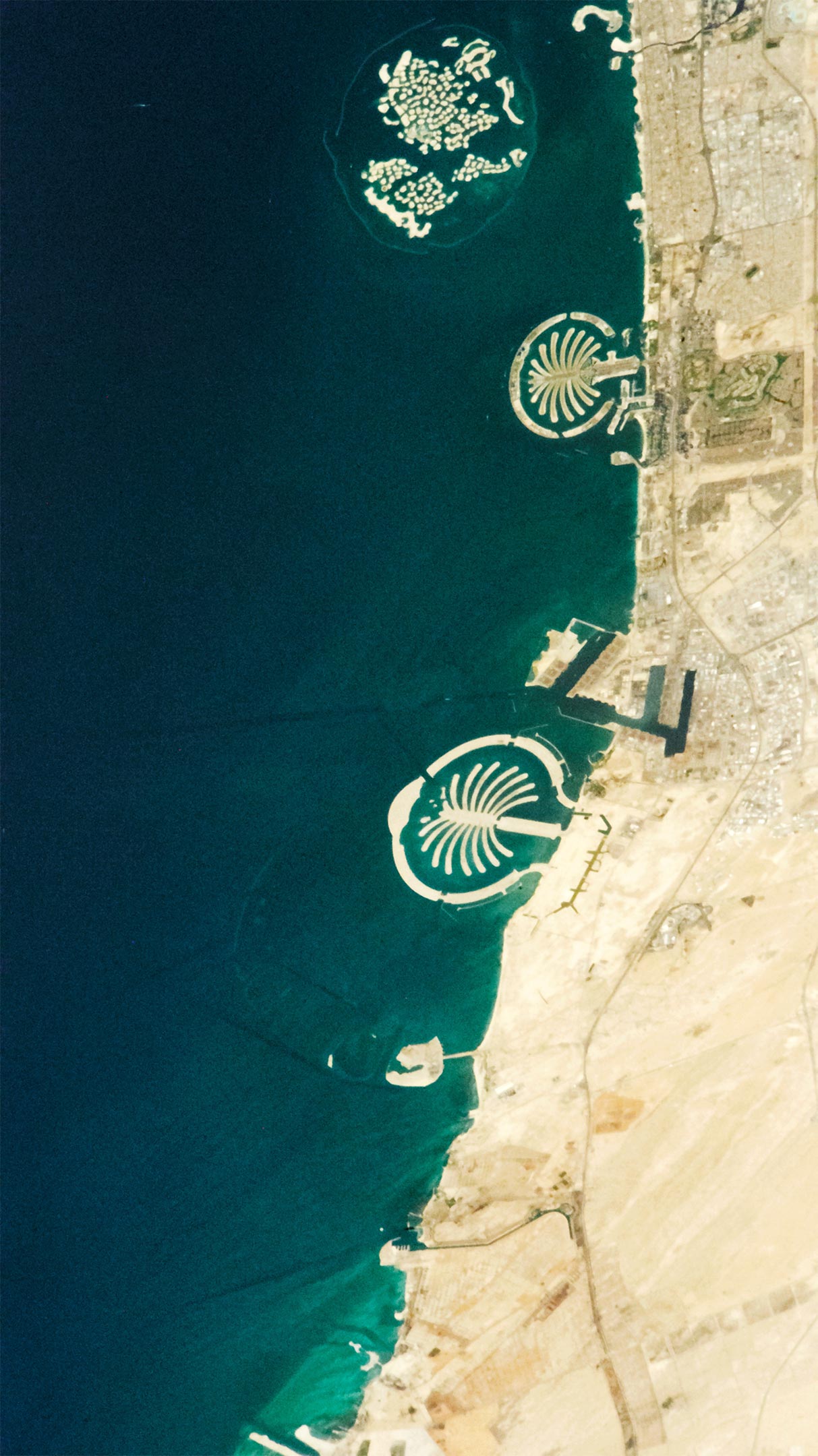
There are no other coastlines on Earth quite like the one along Dubai. Just two decades ago, there was not much of note along the city’s coast, aside from the shallow waters of the Persian Gulf. Today that coastline is the site of some of the largest and most recognizable land reclamation projects in the world.
A pair of palm-shaped islands enclosed by circular storm barriers (Palm Jumeirah and Palm Jebel Ali) and an archipelago designed to look like a map of Earth’s continents stand out in this photograph, which was taken by an astronaut on the International Space Station on April 6, 2022. To construct these unusual coastal landforms, workers dredged sand and silt from the seafloor, sprayed it into the desired shape with ships and GPS technology, and used a piece of construction equipment called a vibroflot to mix in stone and solidify the new islands.
When developers originally created plans for building out Dubai’s coastline in the 1990s, they dreamed big. The Earth-shaped archipelago, called The World Islands, included 300 small sandy islands that were to be sold to luxury developers and filled with hotels and mansions. Rather than having just two palm islands, the original plans called for a third (Palm Deira) that would have been even larger. There were also plans for another expansive archipelago called The Universe that would include islands designed to look like parts of our solar system and the Milky Way.
However, the global recession of 2007 and 2008 delayed and tempered some of that ambition. As financial markets reeled, plans to move forward with The Universe were put on hold. Ambitions were also scaled back considerably for Palm Deira, which is now called the Deira Islands. Palm Jebel Ali remains mostly undeveloped.
Though built, only a handful of the 300 islands in The World have seen development. One of the exceptions is a new resort on Clarence Island, in the South America portion of the archipelago. Another project spread across six islands in the European portion is also close to opening.
As developers work to fund and finish projects, scientists are using satellites to monitor a range of environmental impacts and changes associated with the new landscape. For instance, one international group of researchers noted in a February 2022 paper that there have been significant changes in water quality around Palm Jumeirah. They reported gradual increases in suspended sediment and chlorophyll since 2001, as well as a 7.5 degree Celsius (13.5 degree Fahrenheit) increase in average water temperatures. They did see some temporary improvement in water quality in 2020, when tourism to the island plummeted due to the COVID-19 pandemic. Their findings are based on data collected by Landsat 7 and Landsat 8.
Astronaut photograph ISS067-E-3785 was acquired on April 6, 2022, with a Nikon D4 digital camera using an 380 millimeter lens and is provided by the ISS Crew Earth Observations Facility and the Earth Science and Remote Sensing Unit, Johnson Space Center. The image was taken by a member of the Expedition 67 crew. The image has been cropped and enhanced to improve contrast, and lens artifacts have been removed. The International Space Station Program supports the laboratory as part of the ISS National Lab to help astronauts take pictures of Earth that will be of the greatest value to scientists and the public, and to make those images freely available on the Internet.
Never miss a breakthrough: Join the SciTechDaily newsletter.
Follow us on Google and Google News.
3 Comments
Creating land mass where there was formerly water is permanently and irretrievably additive to global warming. Where is the outrage?
How many liters of fossil fuel has been combusted to move these sand loads and pile them below sea level and keept doing until it came over the surface of the water and more until it matched with both low tide and high tide elevation Just for the sake of desire?
Though yes it is impressive, the Article fails to mention that with rising see levels these ‘land reclamation’projects this will all be for naught as those islands will dissappear soon.Oh and it failed to mention that there used to be a thriving coral reef which was just destroyed and replaced with this essentially failed land reclamation projects.