A NASA satellite captured a stunning mix of cloud streets, spiraling vortices, and a rare polar storm over southern Alaska as winter came to an end.
Southern Alaska closed out the winter of 2026 with a burst of cold, snow, and dramatic weather patterns visible from space. Along parts of the coast, temperatures stayed below normal while rounds of moderate to heavy snowfall swept through the region. Offshore, the atmosphere turned especially turbulent, creating striking cloud formations over the Gulf of Alaska.
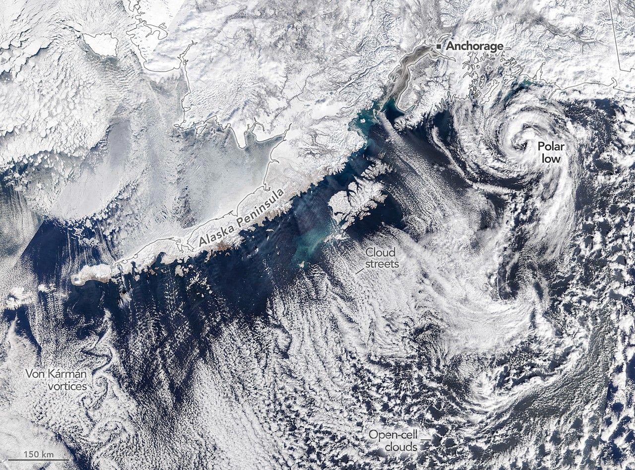
Arctic Air Collides With Warmer Ocean Waters
On March 19, 2026, the last day of astronomical winter, a NASA satellite captured an extraordinary view of the scene unfolding over southern Alaska. According to a NOAA weather briefing, an area of low pressure over the Gulf of Alaska interacted with high pressure positioned across eastern Russia and northern Alaska. That combination funneled frigid Arctic air southeastward over the Alaska Peninsula.
As the cold, dry air moved across comparatively warmer ocean water, it began absorbing heat and moisture. This process produced long rows of clouds known as cloud streets, which appeared in parallel lines matching the direction of the wind. These formations develop when warmer air rises and condenses into clouds while cooler air sinks nearby, creating alternating bands of cloudy and clear skies.
The cloud development did not happen immediately. The air mass needed time over the ocean surface to gather enough warmth and moisture, which helps explain why areas nearest the coast remained mostly free of clouds. (Note that the hazy area close to shore might be stratus or sea fog.) Farther out over the gulf, the cloud streets evolved into open-cell clouds, which resemble delicate rings or wispy walls surrounding open spaces.
Rare Swirling Cloud Patterns Near the Aleutian Islands
Another remarkable feature appeared near Unimak Island, the easternmost of the Aleutian Islands. In the island’s lee, the satellite captured von Kármán vortex streets, a series of staggered, counterrotating swirls forming behind the terrain. These patterns can emerge when strong winds are redirected around elevated landforms rising from the ocean.
Powerful Polar Low Spins Southwest of Anchorage
One of the most eye-catching features in the image was a much larger cloud vortex located about 180 miles (300 kilometers) southwest of Anchorage. Meteorologist Matthew Cappucci identified the system as a polar low, a compact cyclone that forms when cold polar air moves across relatively warm water.
According to Cappucci, this particular storm generated tropical storm-force winds and produced snow and thunderstorms around its center, adding even more intensity to Alaska’s turbulent late winter weather.
A Stormy Pattern Continued Across Alaska
The dramatic conditions seen on March 19 were part of a broader pattern that persisted throughout the month. Alaska experienced ongoing cold temperatures along with repeated periods of stormy weather. Conditions had turned warmer by late April, but reports suggested the unsettled pattern was far from over. An approaching atmospheric river was expected to bring additional wet weather to Southcentral and Southeast Alaska.
NASA Earth Observatory image by Michala Garrison, using MODIS data from NASA EOSDIS LANCE and GIBS/Worldview.
Never miss a breakthrough: Join the SciTechDaily newsletter.
Follow us on Google and Google News.