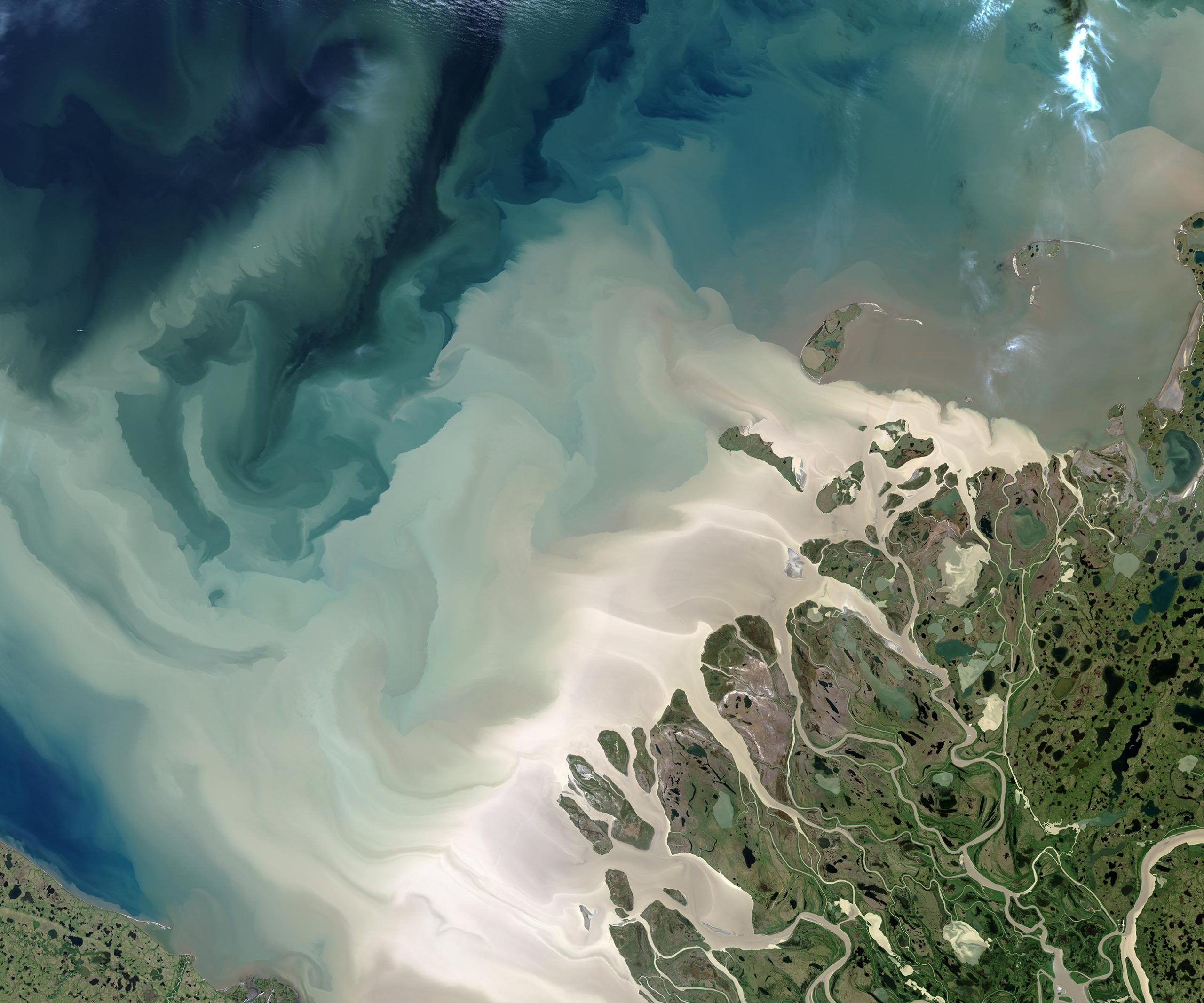
Runoff from one of North America’s largest rivers is driving intense carbon dioxide emissions in the Arctic Ocean.
When it comes to influencing climate change, the world’s smallest ocean punches above its weight. It’s been estimated that the cold waters of the Arctic absorb as much as 180 million metric tons of carbon per year – more than three times what New York City emits annually – making it one of Earth’s critical carbon sinks. But recent findings show that thawing permafrost and carbon-rich runoff from Canada’s Mackenzie River trigger part of the Arctic Ocean to release more carbon dioxide (CO2) than it absorbs.
Mackenzie River’s Influence on Carbon Emissions
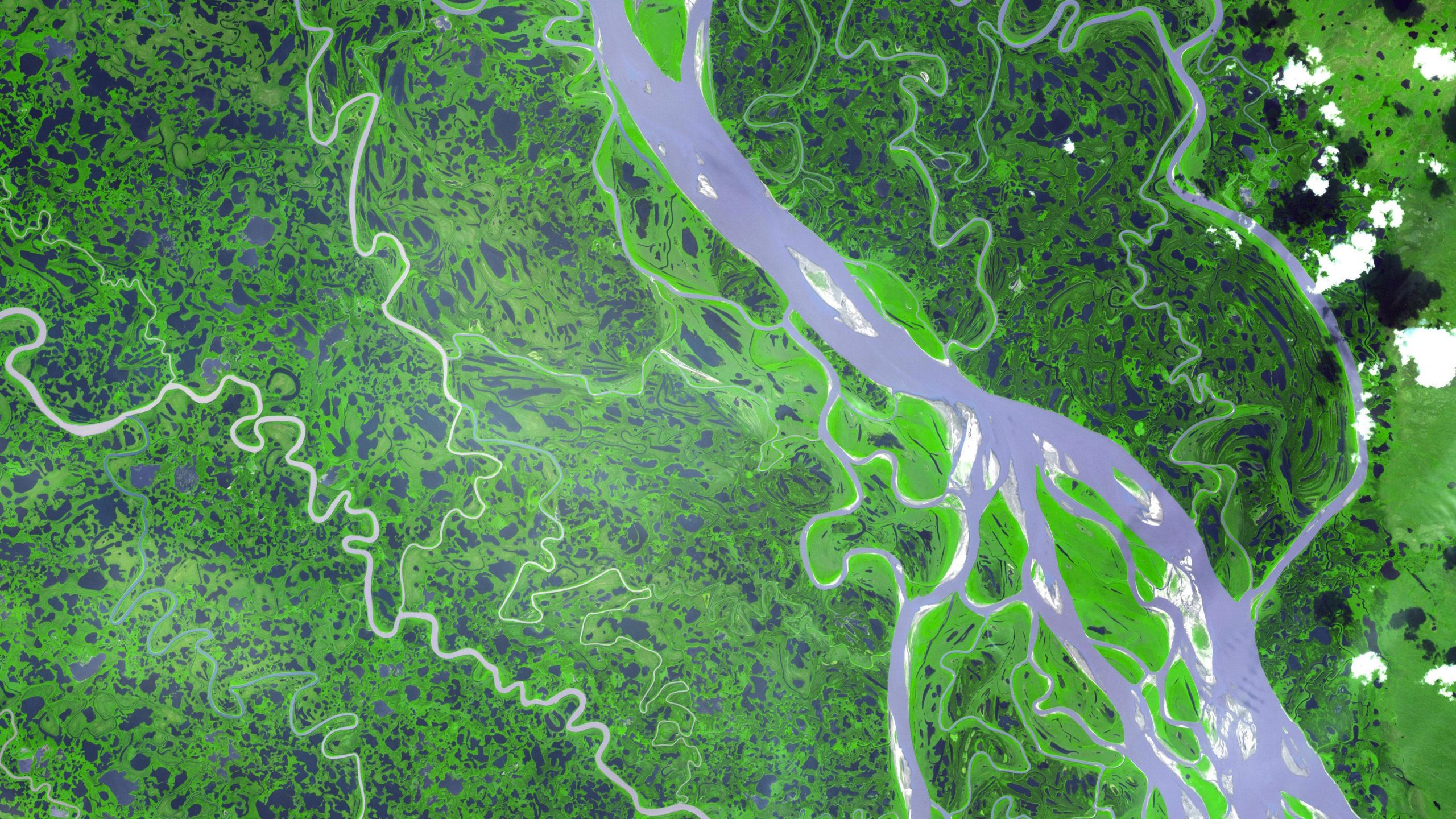
The study, published earlier this year in the journal Geophysical Research Letters, explores how scientists are using state-of-the-art computer modeling to study rivers such as the Mackenzie, which flows into a region of the Arctic Ocean called the Beaufort Sea. Like many parts of the Arctic, the Mackenzie River and its delta have faced significantly warmer temperatures in recent years across all seasons, leading to more melting and thawing of waterways and landscapes.
In this marshy corner of Canada’s Northwest Territories, the continent’s second-largest river system ends a thousand-mile journey that begins near Alberta. Along the way, the river acts as a conveyor belt for mineral nutrients as well as organic and inorganic matter. That material drains into the Beaufort Sea as a soup of dissolved carbon and sediment. Some of the carbon is eventually released, or outgassed, into the atmosphere by natural processes.
Scientists have thought of the southeastern Beaufort Sea as a weak-to-moderate CO2 sink, meaning it absorbs more of the greenhouse gas than it releases. However, there has been great uncertainty due to a lack of data from the remote region.
Advanced Modeling Techniques and Findings
To fill that void, the study team adapted a global ocean biogeochemical model called ECCO-Darwin, which was developed at NASA’s Jet Propulsion Laboratory (JPL) in Southern California and the Massachusetts Institute of Technology (MIT) in Cambridge. The model assimilates nearly all available ocean observations collected for more than two decades by sea- and satellite-based instruments (sea level observations from the Jason-series altimeters, for example, and ocean-bottom pressure from the GRACE and GRACE Follow-On missions).
The scientists used the model to simulate the discharge of fresh water and the elements and compounds it carries – including carbon, nitrogen, and silica – across nearly 20 years (from 2000 to 2019).
The researchers, from France, the U.S., and Canada, found that the river discharge was triggering such intense outgassing in the southeastern Beaufort Sea that it tipped the carbon balance, leading to a net CO2 release of 0.13 million metric tons per year – roughly equivalent to the annual emissions from 28,000 gasoline-powered cars. The release of CO2 into the atmosphere varied between seasons, being more pronounced in warmer months, when river discharge was high and there was less sea ice to cover and trap the gas.
Ground Zero for Climate Change
Scientists have for decades studied how carbon cycles between the open ocean and atmosphere, a process called air-sea CO2 flux. However, the observational record is sparse along the coastal fringes of the Arctic, where the terrain, sea ice, and long polar nights can make long-term monitoring and experiments challenging.
“With our model, we are trying to explore the real contribution of the coastal peripheries and rivers to the Arctic carbon cycle,” said lead author Clément Bertin, a scientist at Littoral Environnement et Sociétés in France.
Such insights are critical because about half of the area of the Arctic Ocean is composed of coastal waters, where land meets sea in a complex embrace. And while the study focused on a particular corner of the Arctic Ocean, it can help tell a larger story of environmental change unfolding in the region.
Since the 1970s, the Arctic has warmed at least three times faster than anywhere else on Earth, transforming its waters and ecosystems, the scientists said. Some of these changes promote more CO2 outgassing in the region, while others lead to more CO2 being absorbed.
For example, with Arctic lands thawing and more snow and ice melting, rivers are flowing more briskly and flushing more organic matter from permafrost and peatlands into the ocean. On the other hand, microscopic phytoplankton floating near the ocean surface are increasingly taking advantage of shrinking sea ice to bloom in the newfound open water and sunlight. These plant-like marine organisms capture and draw down atmospheric CO2 during photosynthesis. The ECCO-Darwin model is being used to study these blooms and the ties between ice and life in the Arctic.
Scientists are tracking these large and seemingly small changes in the Arctic and beyond because our ocean waters remain a critical buffer against a changing climate, sequestering as much as 48% of the carbon produced by burning fossil fuels.
Reference: “Biogeochemical River Runoff Drives Intense Coastal Arctic Ocean CO2 Outgassing” by C. Bertin, D. Carroll, D. Menemenlis, S. Dutkiewicz, H. Zhang, A. Matsuoka, S. Tank, M. Manizza, C. E. Miller, M. Babin, A. Mangin and V. Le Fouest, 15 April 2023, Geophysical Research Letters.
DOI: 10.1029/2022GL102377
Never miss a breakthrough: Join the SciTechDaily newsletter.
Follow us on Google and Google News.
1 Comment
“…, The study, …, explores how scientists are using state-of-the-art computer modeling to study rivers such as the Mackenzie, …”
One should be careful to not confuse the results of modeling with empirical measurements. In well-designed models, for which there are adequate field measurements for calibration, models may do a good job of simulating reality. However, the article says, with respect to whether the Arctic is a weak-to-moderate sink or a source, “…, there has been great uncertainty due to a lack of data from the remote region.” All the more reason to avoid jumping to conclusions.
The article states, “The researchers, …, found that the river discharge was triggering such intense outgassing in the southeastern Beaufort Sea that it tipped the carbon balance, leading to a net CO2 release of 0.13 million metric tons per year. They provide some context by stating that the release is equivalent to 28,000 cars. However, another way of looking at it is that the 0.13 million metric tons is equivalent to about 0.00002 parts per million (PPM) of the atmosphere. CO2 is typically measured and reported to a precision of +/-0.05 PPM. In other words, what is happening in the Arctic is not measurable on a global scale! It may play a significant part in regional warming, but the global impact will only be secondary.