A sprawling low-pressure system swept across the eastern half of the U.S., delivering high winds, heavy rain and snow, and tornado damage.
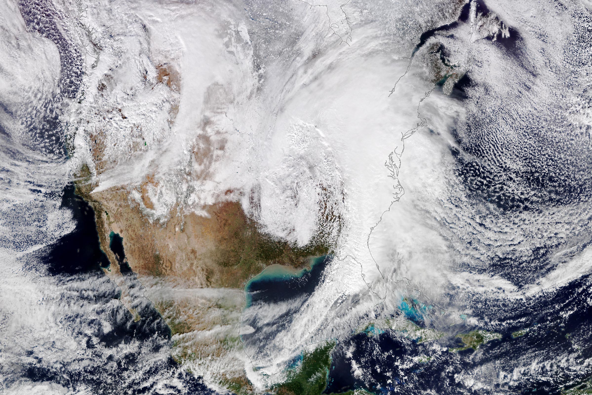
A potent winter storm plowed across the eastern half of the United States on January 9, 2024, delivering heavy rain and snow, strong winds, and damaging tornadoes. That afternoon, the VIIRS (Visible Infrared Imaging Radiometer Suite) on the NOAA-20 satellite acquired this natural-color image (above) of the sprawling storm clouds.
Winter Weather Across Eastern U.S.
The system spawned abundant precipitation, which fell as snow on the storm’s colder side. According to the National Weather Service, parts of Iowa saw snowfall totals of up to 15 inches (38 centimeters). Warmer areas, such as the Mid-Atlantic, saw several inches of rain. The water caused rivers in the Northeast to rise to flood stage, and forced people living along the Yantic River in New Jersey and Connecticut to evacuate, according to news reports.
High-Impact Weather Conditions
Earlier in the day, around 10:45 a.m. Eastern Time (15:45 Universal Time), the MODIS (Moderate Resolution Imaging Spectroradiometer) on NASA’s Terra satellite acquired the detailed image below. This false-color image highlights infrared observations of brightness temperature, which helps distinguish the shape and temperature of the clouds. White and light-purple cloud tops are cooler than dark-purple and yellow surfaces.
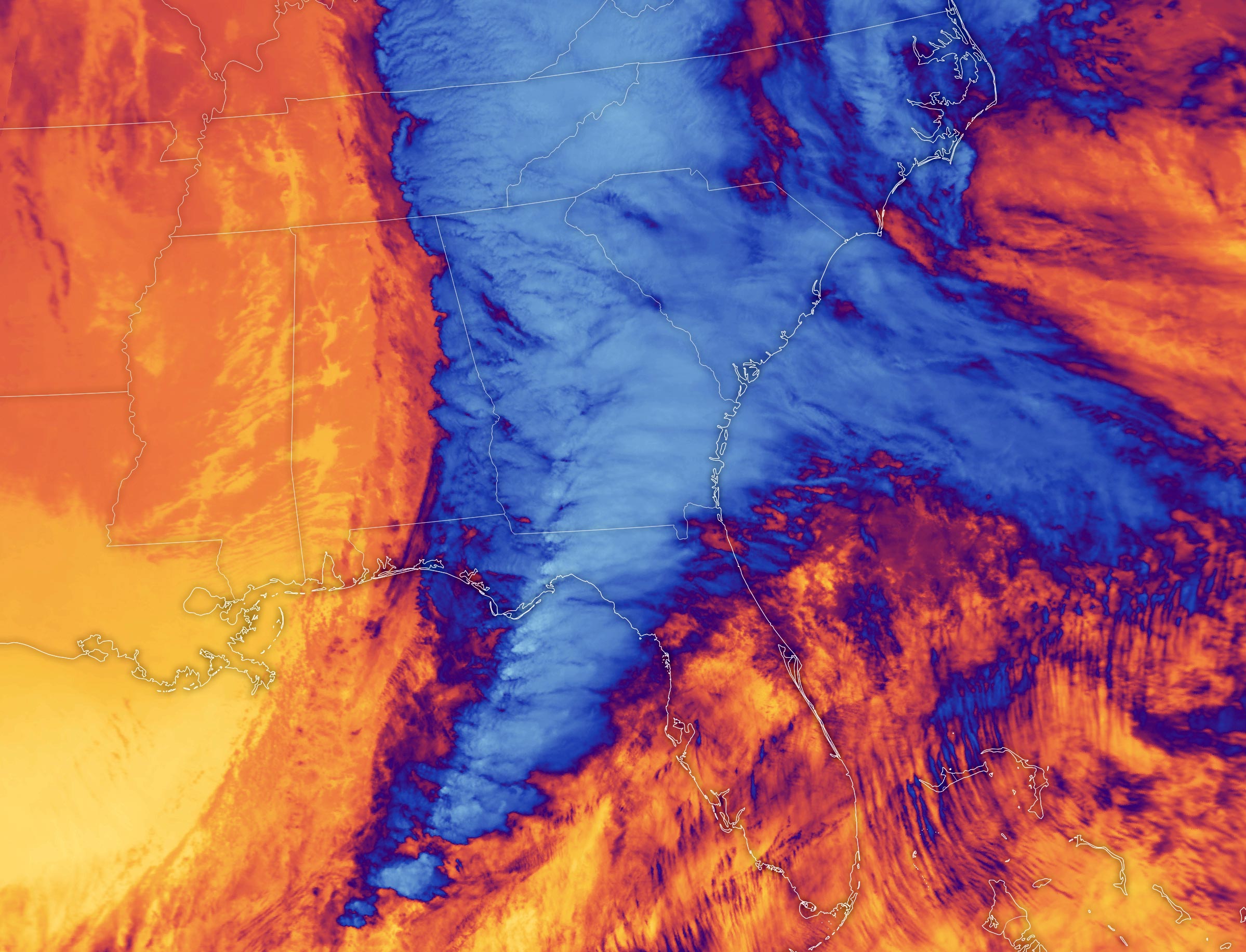
Notice the patches of bright white cloud tops forming a line over the Gulf of Mexico, Florida Panhandle, and southern Georgia. According to Kristopher Bedka, an atmospheric scientist at NASA’s Langley Research Center, these dome-like protrusions, or overshooting clouds, arose from the intense updrafts associated with thunderstorms in the area. The features are more common in storms that create the most severe weather.
Severe Weather Reports
The updrafts and associated atmospheric processes led to hazardous weather conditions at ground level on January 9. For example, reports from NOAA’s Storm Prediction Center indicate that high winds and damaging tornadoes occurred in Florida and Georgia around the time of the Terra image. One report north of Albany, Georgia, cited a wind gust of nearly 93 miles (150 kilometers) per hour. Elsewhere across the region, cool cloud tops were associated with heavy rain and areas of flooding.
Upcoming Winter Weather
Forecasts are calling for more winter weather to hit a similar part of the U.S. later in the week. That storm system will be coming from the Pacific Northwest, parts of which saw blizzard conditions on January 9.
NASA Earth Observatory images by Lauren Dauphin, using VIIRS data from NASA EOSDIS LANCE, GIBS/Worldview, and the Joint Polar Satellite System (JPSS) and MODIS data from NASA EOSDIS LANCE and GIBS/Worldview.
Never miss a breakthrough: Join the SciTechDaily newsletter.
Follow us on Google and Google News.