
Close Menu
    Facebook X (Twitter) Instagram
    SciTechDaily
    • Biology
    • Chemistry
    • Earth
    • Health
    • Physics
    • Science
    • Space
    • Technology
    Facebook X (Twitter) Pinterest YouTube RSS
    SciTechDaily
    Home»Earth»‘Blue Marble’ Image of the Earth Taken from NASA’s Suomi NPP Satellite
    Earth

    ‘Blue Marble’ Image of the Earth Taken from NASA’s Suomi NPP Satellite

    By NASAJanuary 26, 2012No Comments2 Mins Read
    Facebook Twitter Pinterest Telegram LinkedIn WhatsApp Email Reddit
    Share
    Facebook Twitter LinkedIn Pinterest Telegram Email Reddit
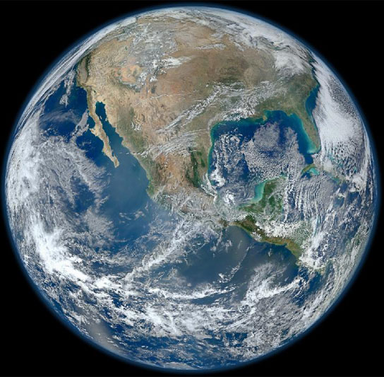
    'Blue Marble' Image of the Earth
    ‘Blue Marble’ Image of the Earth taken from the VIIRS instrument aboard NASA’s most recently launched Earth-observing satellite – Suomi NPP. Credit: NASA/NOAA/GSFC/Suomi NPP/VIIRS/Norman Kuring

    NASA’s Earth-observing satellite, Suomi NPP, captured this “Blue Marble” image of Earth on January 24, 2012, using the Visible Infrared Imager Radiometer Suite. As you can see, the HD photo is a vast improvement over the photo taken on December 7, 1972.

    A ‘Blue Marble’ image of the Earth taken from the VIIRS instrument aboard NASA’s most recently launched Earth-observing satellite – Suomi NPP. This composite image uses a number of swaths of the Earth’s surface taken on January 4, 2012. The NPP satellite was renamed ‘Suomi NPP’ on January 24, 2012, to honor the late Verner E. Suomi of the University of Wisconsin.

    Suomi NPP is NASA’s next Earth-observing research satellite. It is the first of a new generation of satellites that will observe many facets of our changing Earth.

    Suomi NPP is carrying five instruments on board. The biggest and most important instrument is The Visible/Infrared Imager Radiometer Suite or VIIRS.
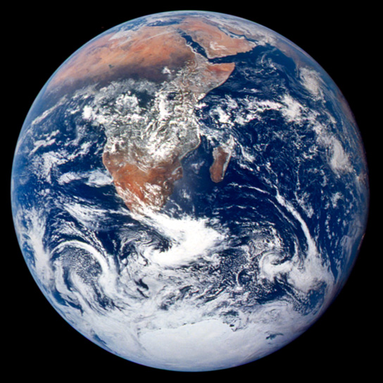
    1972 Blue Marble Image
    Credit: NASA Johnson Space Center

    This classic photograph of the Earth was taken on December 7, 1972. The original caption is reprinted below:

    View of the Earth as seen by the Apollo 17 crew traveling toward the moon. This translunar coast photograph extends from the Mediterranean Sea area to the Antarctica south polar ice cap. This is the first time the Apollo trajectory made it possible to photograph the south polar ice cap. Note the heavy cloud cover in the Southern Hemisphere. Almost the entire coastline of Africa is clearly visible. The Arabian Peninsula can be seen at the northeastern edge of Africa. The large island off the coast of Africa is the Malagasy Republic. The Asian mainland is on the horizon toward the northeast.

    Never miss a breakthrough: Join the SciTechDaily newsletter.
    Follow us on Google and Google News.

    NASA Popular
    Share. Facebook Twitter Pinterest LinkedIn Email Reddit

    Related Articles

    Arctic Shifts to Carbon Source – Stunning Reversal After Capturing Carbon for Tens of Thousands of Years

    El Niño Continues to Grow, Set to Bear Down on U.S.

    2015 El Niño Appears Likely to Equal the Event of 1997-98

    Cassini Will Photograph Earth in Natural Color

    Satellites Confirm Extensive Ice Sheet Melt in Greenland

    Ancient Antarctica Was Much Warmer and Wetter Than Previously Suspected

    NASA Makes Earth’s Oceans Look like Van Gogh’s Starry Night

    NASA Launched Rocket into Aurora Borealis

    Research Shows Roughly 150 Billion Tons of Ice Lost Annually

    Leave A Reply Cancel Reply

    • Facebook
    • Twitter
    • Pinterest
    • YouTube

    Don't Miss a Discovery

    Subscribe for the Latest in Science & Tech!

    Trending News

    These Toads Are Surviving a Deadly Fungus – Scientists May Finally Know Why

    These Brain Cells May Explain Why We Eventually Have To Sleep

    Tomatoes Contain an Invisible Ingredient With Surprising Effects on Liver Health

    World’s First Heat-Powered Cooling System Turns Waste Heat Into Cold

    Antarctica Gained a Record 695 Billion Tons of Ice in Just Two Years

    Don’t Miss: A Brilliant Venus and Glowing Harvest Moon Light Up the Sky

    New Twist on the Einstein Problem Reveals Unexpected Physics

    JWST Captures Stunning Evidence of How Supermassive Black Holes Feed

    Follow SciTechDaily
    • Facebook
    • Twitter
    • YouTube
    • Pinterest
    • Newsletter
    • RSS
    SciTech News
    • Biology News
    • Chemistry News
    • Earth News
    • Health News
    • Physics News
    • Science News
    • Space News
    • Technology News
    Recent Posts
    • Scientists Discover a Hidden Defect That Could Explain Why IBD Keeps Coming Back
    • Millions Take Blood Pressure Drugs, but Many May Be Missing Their Heart-Protective Benefits
    • Could Alien Life Be Conscious in Ways We Can’t Imagine?
    • Scientists Develop a Fruit Wash That Removes Pesticide Residues and Keeps Produce Fresh Longer
    • Scientists May Have Finally Explained Why Astronauts Get Constipated in Space
    Copyright © 1998 - 2026 SciTechDaily. All Rights Reserved.
    • Science News
    • About
    • Contact
    • Editorial Board
    • Privacy Policy
    • Terms of Use

    Type above and press Enter to search. Press Esc to cancel.