Close Menu
    Facebook X (Twitter) Instagram
    SciTechDaily
    • Biology
    • Chemistry
    • Earth
    • Health
    • Physics
    • Science
    • Space
    • Technology
    Facebook X (Twitter) Pinterest YouTube RSS
    SciTechDaily
    Home»Earth»Exploring Earth From Space: New York City [Video]
    Earth

    Exploring Earth From Space: New York City [Video]

    By European Space AgencyOctober 2, 2020No Comments3 Mins Read
    Facebook Twitter Pinterest Telegram LinkedIn WhatsApp Email Reddit
    Share
    Facebook Twitter LinkedIn Pinterest Telegram Email Reddit
    New York City Sentinel Satellite Zoom
    Image captured on August 26, 2019, by the Copernicus Sentinel-2 mission. Credit: Contains modified Copernicus Sentinel data (2019), processed by ESA, CC BY-SA 3.0 IGO

    The Copernicus Sentinel-2 mission takes us over New York City – the most populous city in the United States.

    With a population of over 8 million people distributed over an area of around 780 sq km (300 sq mi), New York City is the most densely populated major city in the US. Situated on one of the world’s largest natural harbors, New York City is composed of five boroughs.

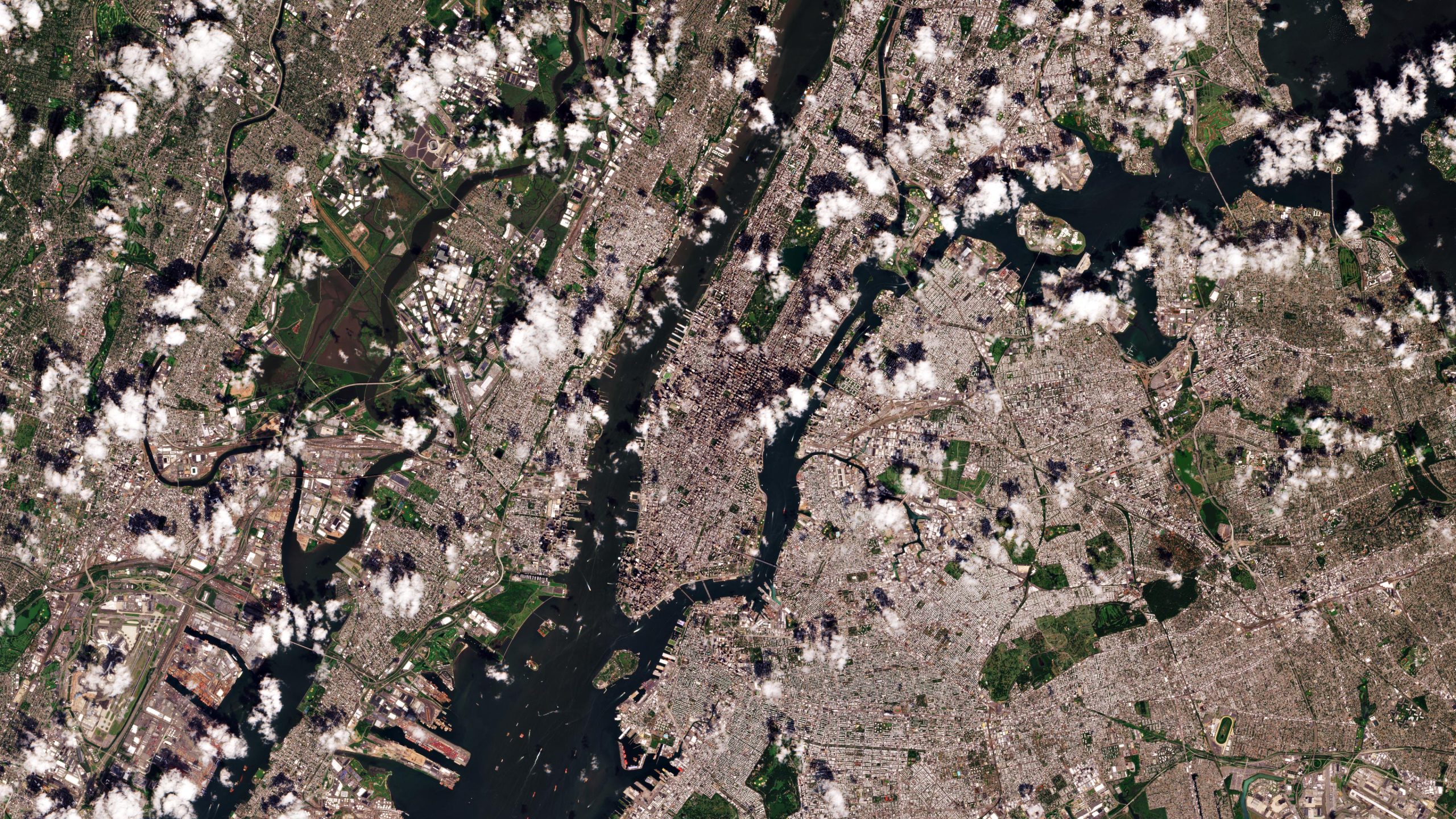
    In this image, captured on August 26, 2019, the island of Manhattan is visible in the center, bounded by the Hudson, East, and Harlem rivers. In the middle of Manhattan, Central Park can be seen as a long, green rectangle with a large lake in the middle.

    The Brooklyn and Queens boroughs can be seen on the right. John F. Kennedy International Airport – the busiest international air passenger gateway into North America – can easily be identifiable in the lower right of the image.

    The Bronx is visible north of Manhattan, while Staten Island can be seen in the lower left of the image. New Jersey dominates the upper left side of the image.

    New York City’s 900 km (560 mi) of shoreline border the ocean, rivers, inlets, and bays, and a harbor that is home to one of the largest ports on the east coast. Like many other cities that border an ocean, New York is at risk of flooding due to rising sea levels.

    Data show that since 1993, the global mean sea level has risen, on average, just over 3 mm every year. Even more worryingly, this rate of rise has increased in recent years.

    Sea level rise flooding of US coastlines is becoming more frequent each year. Rising sea levels are expected to worsen storm flooding in low-lying neighborhoods in coastal areas, and permanently inundate some parts. Retreating shorelines and accelerating erosion will threaten coastal homes and businesses.

    New York City Sentinel Satellite
    Image captured on August 26, 2019, by the Copernicus Sentinel-2 mission. Credit: Contains modified Copernicus Sentinel data (2019), processed by ESA, CC BY-SA 3.0 IGO

    The upcoming Copernicus Sentinel-6 Michael Freilich satellite, set to launch in November from the Vandenberg Air Force Base in California, US, is the first of two identical satellites that will provide observations of sea level change.

    Each Sentinel-6 satellite carries an altimeter that works by measuring the time it takes for radar pulses to travel to Earth’s surface and back again to the satellite. Combined with precise satellite location data, altimetry measurements yield the height of the sea surface.

    Never miss a breakthrough: Join the SciTechDaily newsletter.
    Follow us on Google and Google News.

    European Space Agency Geography
    Share. Facebook Twitter Pinterest LinkedIn Email Reddit

    Related Articles

    Breathtaking View of Andros, Bahamas From Space [Video]

    Stunning Views of Houston Texas From Copernicus Sentinel-1 Satellite

    Earth From Space: Bolivian Highland Heart [Video]

    Flevoland, Netherlands From Space: One of the Largest Land Reclamation Projects in the World

    Earth From Space: Lake George, Uganda – A Center for Biological Diversity [Video]

    Deforestation in Bolivia Spied From Space Satellite

    Earth From Space: Japanese Archipelago [Video]

    Earth From Space: Faroe Islands [Video]

    Earth From Space: Tromsø, Norway [Video]

    Leave A Reply Cancel Reply

    • Facebook
    • Twitter
    • Pinterest
    • YouTube

    Don't Miss a Discovery

    Subscribe for the Latest in Science & Tech!

    Trending News

    Scientists May Have Discovered How To Heal Damaged Kidneys

    Interstellar Visitor 3I/ATLAS Is Bursting With an Unexpected Chemical

    Scientists Just Found All 5 Genetic “Letters” of DNA and RNA on an Asteroid

    The 4,000-Year-Old City That Defied History’s Rules on Wealth and Power

    The World’s Biggest Population Fear Has Flipped – and It Could Change Everything

    This “Fake” Pill Improved Memory and Physical Performance in Just 3 Weeks

    Scientists Say Frequent Ejaculation May Improve Sperm Quality and Fertility

    Scientists Have Found “The Heaven Sword” After Years of Looking

    Follow SciTechDaily
    • Facebook
    • Twitter
    • YouTube
    • Pinterest
    • Newsletter
    • RSS
    SciTech News
    • Biology News
    • Chemistry News
    • Earth News
    • Health News
    • Physics News
    • Science News
    • Space News
    • Technology News
    Recent Posts
    • Physicists Discover a Fundamental Limit to Electrical Resistance
    • Physicists Solve a “Quantum-Only” Problem Using an Ordinary Laptop
    • Scientists Unlock Hidden DNA From 1,300-Year-Old Manuscripts
    • Scientists Discover the Brain Can Rewire Itself To Truly Multitask
    • mRNA Vaccine Shrinks Deadly Childhood Cancer Tumors by 70%
    Copyright © 1998 - 2026 SciTechDaily. All Rights Reserved.
    • Science News
    • About
    • Contact
    • Editorial Board
    • Privacy Policy
    • Terms of Use

    Type above and press Enter to search. Press Esc to cancel.