October 10 – 25, 2021
One of the most intense extratropical cyclones ever to strike the Pacific Northwest drew an equally historic amount of moisture onshore.
One of the most intense extratropical cyclones ever to strike the Pacific Northwest drew an equally historic amount of moisture onto the West Coast of North America on October 24-25, 2021. The storm off the coast of Washington—with a central pressure of 942.5 millibars, equivalent to a category 4 hurricane—was the second extreme low-pressure storm in the North Pacific in a week. Both exhibited pressure drops of more than 24 millibars in 24 hours, making them “bomb cyclones.”
The two storm fronts directed streams of moisture from north of Hawaii toward the West Coast in long, narrow bands of moisture known as atmospheric rivers. Atmospheric rivers account for up to 50 percent of all rain and snow that falls in the western United States.
The parade of storms brought high winds and extreme precipitation that doused wildfires and brought some relief from extreme drought to Central and Northern California. But the events also caused power outages, flooding, landslides, and mud and debris flows that washed out roads.
The animation above shows a model of the movement of total precipitable water vapor over the eastern Pacific Ocean from October 10-25, 2021. Green areas represent the highest amounts of moisture. Note the fingers of white to light green that repeatedly flow into the Pacific Northwest of North America. Note also how areas in the tropics are often saturated with moisture that can eventually curl up into middle latitudes.
Total precipitable water vapor is a measurement of the amount of water in a column of the atmosphere if all the water vapor in that column were condensed into liquid. The animation was derived from a NASA product known as the Goddard Earth Observing System Data Assimilation System (GEOS DAS), which uses satellite data and mathematical representations of physical processes to calculate what is happening in the atmosphere. Not all precipitable water vapor actually falls as rain. However, it is a useful indicator of regions where rainfall could be excessive.
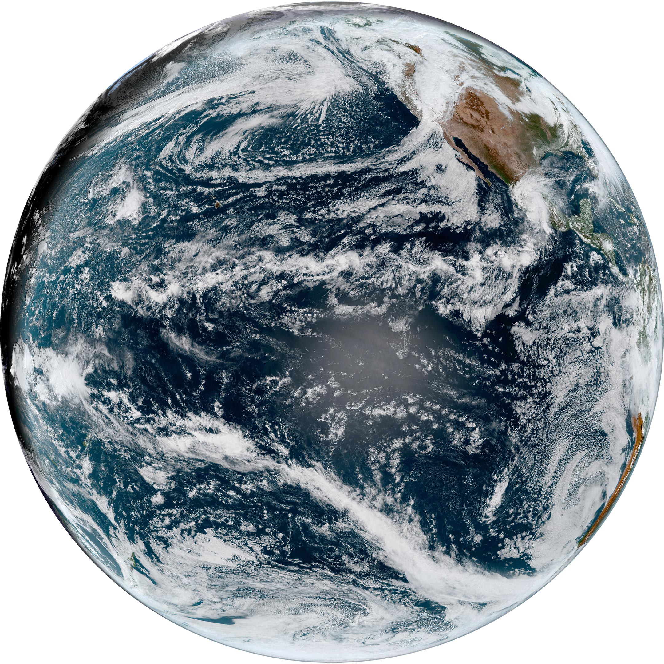
The simulated natural-color image above, acquired on October 25 by NOAA’s Geostationary Operational Environmental Satellite 17 (GOES-17) shows an arc of clouds stretching across the Pacific—a visible manifestation of the atmospheric river pouring moisture into the Pacific Northwest. GOES-17 is operated by the National Oceanic and Atmospheric Administration (NOAA); NASA helps develop and launch the GOES series of satellites.
The Center for Western Weather and Water Extremes ranked the October 24-25 atmospheric river as a category-5 event for the San Francisco Bay Area. The 1 to 5 scale considers the longevity and the amount of water vapor carried by these rivers of moist air that travel ahead of cold fronts.
In Marin County, the National Weather Service (NWS) reported that Mount Tamalpais received a 48-hour total of 16.55 inches (42 centimeters) of precipitation by the morning of October 25. Downtown San Francisco recorded 4.02 inches (10.2 centimeters) on October 24 alone, making it the wettest October day the city has seen since record keeping began.
In Blue Canyon, California, 10.4 inches of rain fell in a 24-hour period on October 24-25, breaking a record of 9.33 inches (23.7 centimeters) set in 1964, according to the NWS. Over the same period, downtown Sacramento saw 5.44 inches (13.8 centimeters) of rain, breaking a record set in 1880. Just one week before, Sacramento had broken another extreme record for the longest dry spell, marking 212 days without measurable rain.
On October 24, the NWS issued flash flood warnings for 13 burn scar areas in California from wildfires that occurred between 2018 and 2021. The warnings included the Caldor fire burn scar near Lake Tahoe, where several more inches of rain were expected to fall on October 25.
Up and down the California coast, NWS issued high surf warnings for swells of 16 to 24 feet (5 to 7 meters) on west to northwest facing beaches. At the same time, winter storm warnings were in effect in the Sierra Nevada, where multiple feet of snow were expected at high elevations. Remnants of the storm were expected to reach Southern California late on October 25.
NASA Earth Observatory image and video by Joshua Stevens, using GOES 17 imagery courtesy of NOAA and the National Environmental Satellite, Data, and Information Service (NESDIS) and GEOS-5 data from the Global Modeling and Assimilation Office at NASA GSFC.
Never miss a breakthrough: Join the SciTechDaily newsletter.
Follow us on Google and Google News.