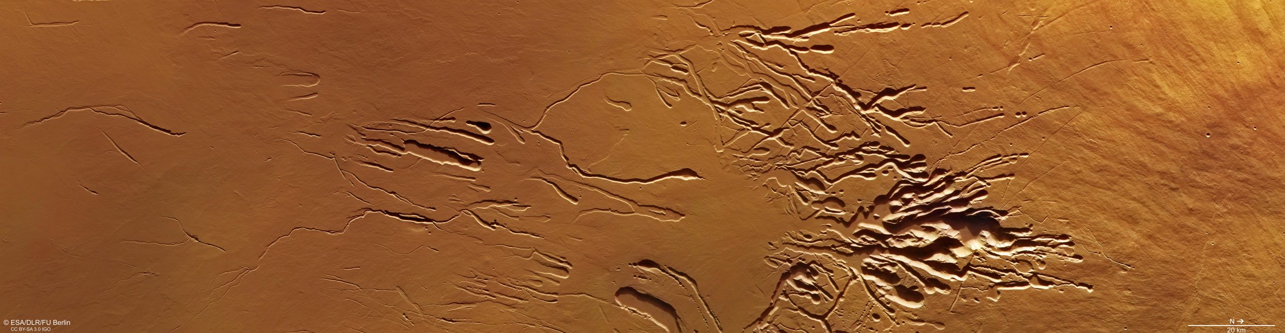
This image comprises data gathered by Mars Express’ High Resolution Stereo Camera (HRSC) on January 15, 2023, during orbit 24045. It was created using data from the nadir channel, the field of view aligned perpendicular to the surface of Mars, and the color channels of the HRSC. It is a ‘true color’ image, reflecting what would be seen by the human eye if looking at this region of Mars. North is to the right. Credit: ESA/DLR/FU Berlin, CC BY-SA 3.0 IGO
ESA’s Mars Express has captured detailed images of Mars’ second-tallest volcano, Ascraeus Mons, revealing features such as lava flows, tubes, chains of craters, and large fissures created by a combination of lava, ash, and water flows, and the presence of subsurface voids.
Mars has some of the most impressive volcanoes in the Solar System. ESA’s Mars Express has now imaged the pitted, fissured flank of the planet’s second-tallest: Ascraeus Mons.
This image comprises observations from Mars Express’ High Resolution Stereo Camera (HRSC).
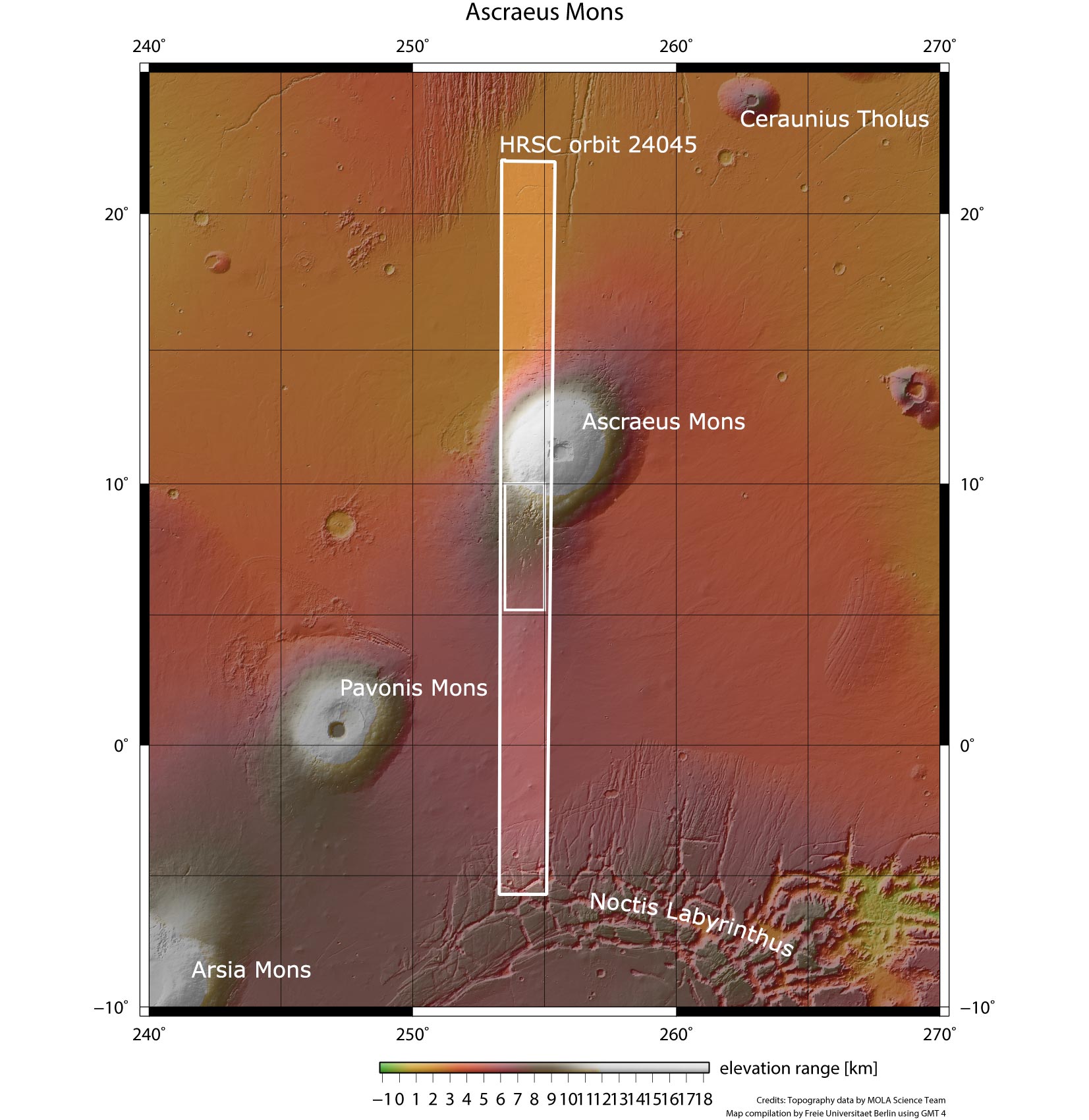
Ascraeus Mons is the northernmost and tallest of three prominent volcanoes found in the Tharsis region of Mars, a volcanic plateau in Mars’ western hemisphere. It measures a towering 18 km (11 miles) in height but its slopes are gentle, with an average incline of 7 degrees. This slow climb is reflected in the volcano’s huge base diameter of 480 km (300 miles), giving it a footprint roughly the size of Romania on Earth.
Ascraeus Mons is surpassed in height only by Olympus Mons, the tallest volcano not only on Mars but in the entire Solar System.
Like Ink Into Water
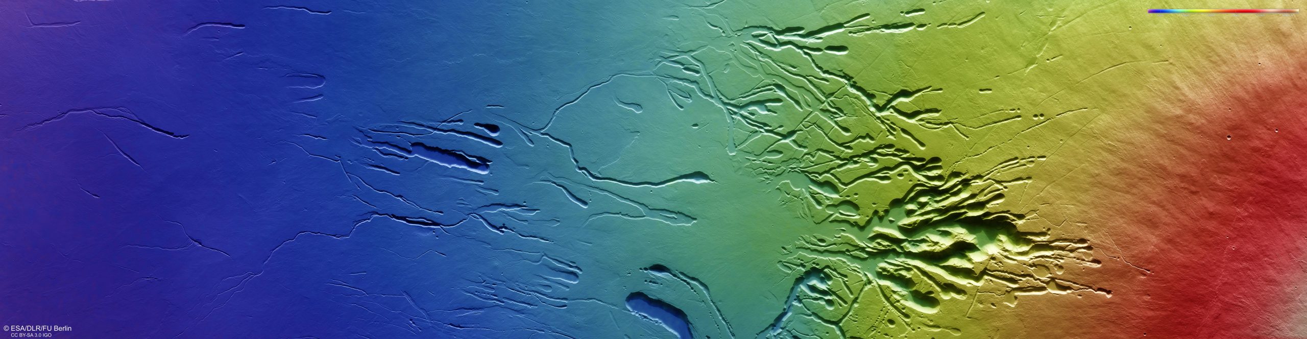
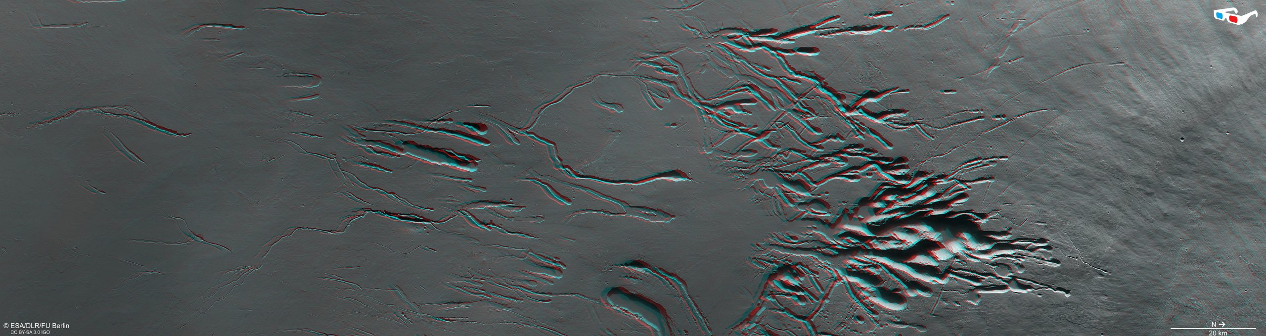
The image shows the lower southern flank of Ascraeus Mons. There is a dramatic difference in elevation from one side to the other, with the left (southern) side of the frame sitting about 10 km lower than the right (northern) side. The volcano’s peak is found to the right (north) of the frame, as seen most clearly in the wider context map of the region.
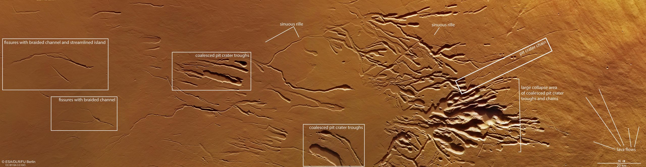
Many similarly dramatic features – collectively named Ascraeus Chasmata, encompassing an enormous patch of collapsed terrain over 70 km (44 miles) across – are visible across the frame: lava flows and tubes, chains of craters, channel-like rilles, and large fissures spanning tens of km in length.
All of different age and origin, these features knit together to form a scene resembling trails of ink dispersing artfully in water, or a plant’s beautifully complex root system as it digs down into soil.
Lurking Below Ground
To the right side of the frame lie numerous wrinkled lava flows. This crinkled ground then encounters chains of ‘pit craters’: features where strings of circular or near-circular depressions have combined and coalesced to form troughs. We see these on Earth too, with a notable example being the dramatic Cenotes found on the Yucatán Peninsula, Mexico. The pit crater troughs and chains shown here have also grouped together to form an especially large and eye-catching collapse area.
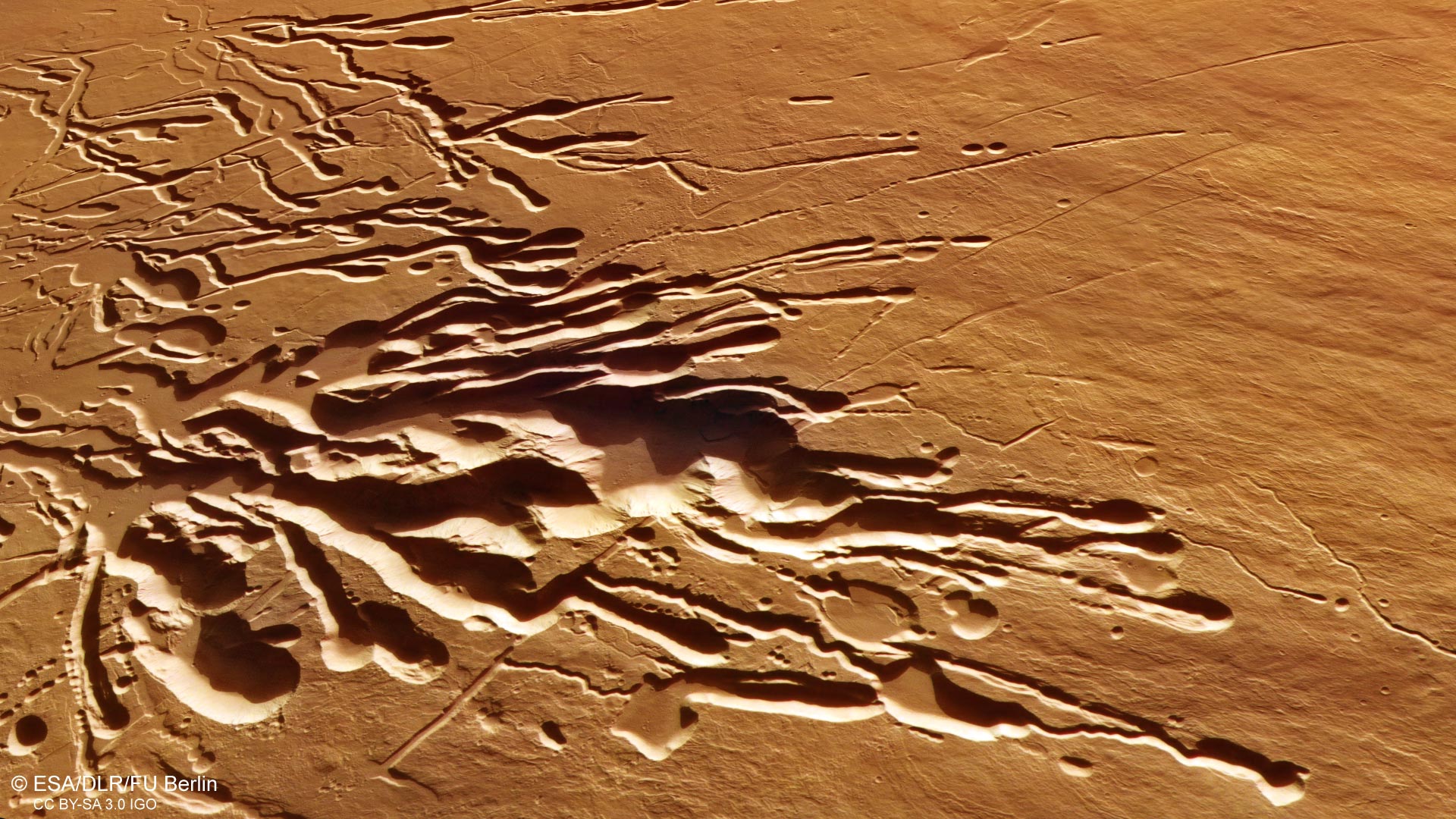
These chains and troughs likely form where hidden voids lie below the surface, causing the ground to become unstable and collapse – a bit like a sinkhole. The subsurface voids are thought to be created as the surface layer of a lava flow rapidly cools and hardens; the lava flow beneath then ceases and ebbs away over time, leaving tube-shaped pockets of space lurking several meters below ground.
The ground to the left of the pit crater chains is marked by so-called ‘sinuous rilles’: smaller, snaking channels without rims that are often found at the flanks of volcanoes. It is still unclear how these form, but their creation may involve flows of lava, ash, or water – or a combination of the three.
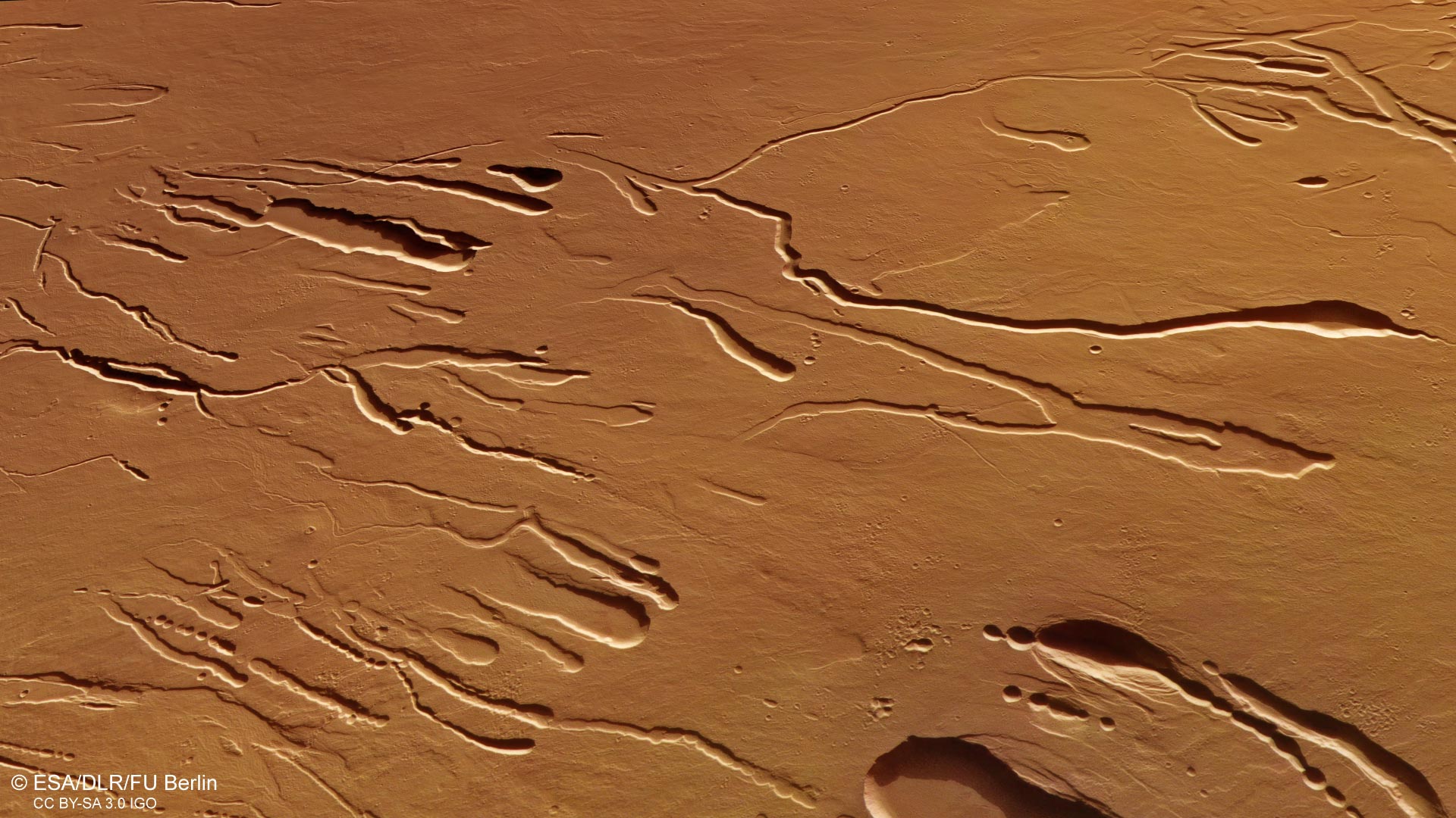
The leftmost part of the image is dominated by large fissures of up to 40 km (25 miles) long. Branching out from these fissures are channels that weave and braid together (‘braided channels’), isolating chunks of martian terrain to form ‘islands’ and terraces. These are likely to have formed by water – perhaps as snow and ice built up on the flanks of Ascraeus Mons before later melting away.
Exploring Mars
Mars Express has been orbiting the Red Planet since 2003, imaging Mars’ surface, mapping its minerals, identifying the composition and circulation of its tenuous atmosphere, probing beneath its crust, and exploring how various phenomena interact in the martian environment.
The orbiter’s HRSC, responsible for these new images, has revealed much about Mars’ diverse surface features, with images showing everything from the mighty Valles Marineris canyon system, deep fractures and water-carved valleys to impact craters, tectonic faults, river channels, and ancient lava pools. Many Mars Express images feature the Red Planet’s immense volcanoes, of which Ascraeus Mons is a fascinating example.
The mission’s High Resolution Stereo Camera (HRSC) was developed and is operated by the German Aerospace Center (Deutsches Zentrum für Luft- und Raumfahrt; DLR).
Never miss a breakthrough: Join the SciTechDaily newsletter.
Follow us on Google and Google News.