
Close Menu
    Facebook X (Twitter) Instagram
    SciTechDaily
    • Biology
    • Chemistry
    • Earth
    • Health
    • Physics
    • Science
    • Space
    • Technology
    Facebook X (Twitter) Pinterest YouTube RSS
    SciTechDaily
    Home»Earth»Monitoring the Devastating US-Canada Heatwave From Space
    Earth

    Monitoring the Devastating US-Canada Heatwave From Space

    By European Space AgencyJuly 2, 20211 Comment2 Mins Read
    Facebook Twitter Pinterest Telegram LinkedIn WhatsApp Email Reddit
    Share
    Facebook Twitter LinkedIn Pinterest Telegram Email Reddit
    US Canada Heatwave June 2021
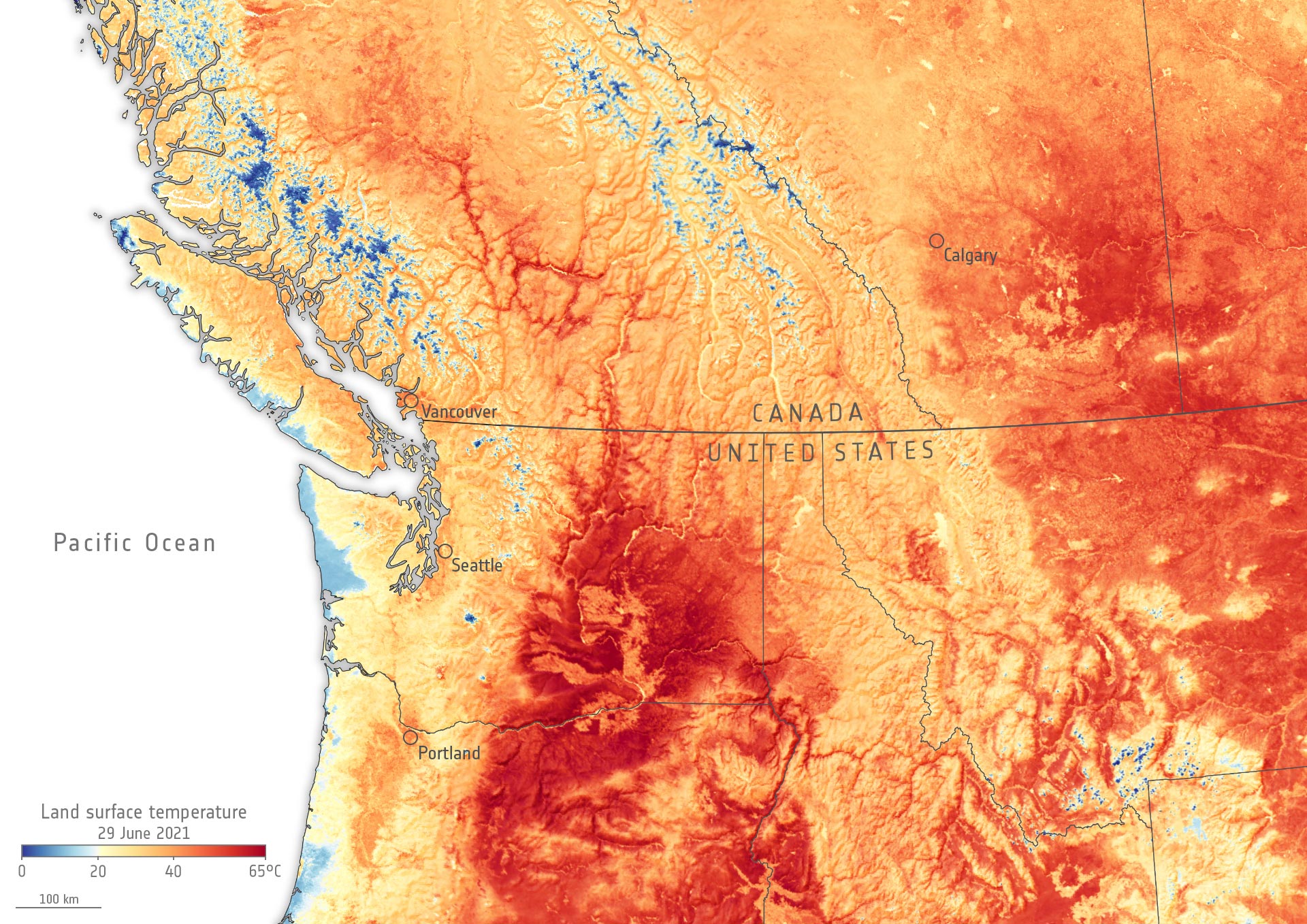
    Map of the northwest United States and southwest Canada on June 29, 2021, generated using data from the Copernicus Sentinel-3 mission. Credit: Contains modified Copernicus Sentinel data (2021), processed by ESA, CC BY-SA 3.0 IGO

    While heatwaves are quite common during the summer months, the scorching heatwave hitting parts of western Canada and the US has been particularly devastating – with temperature records shattered and hundreds of people falling victim to the extreme heat.

    Canada broke its temperature record for a third consecutive day: recording a whopping 49.6°C (121.3°F) on 29 June in Lytton, a village northeast of Vancouver, in British Columbia.

    Portland, Oregon, also broke its all-time temperature record for three days in a row.

    The extent of the heatwave can be seen in this map, which shows the land surface temperature of parts of Canada and the US on 29 June. The data show that surface temperatures in Vancouver and Portland reached 43°C (109.4°F), and Calgary recorded 45°C (113°F). The hottest temperatures recorded are in the state of Washington (visible in deep red) with maximum land surface temperatures of around 69°C (156.2°F).

    The map has been generated using data from the Copernicus Sentinel-3 mission. While weather forecasts typically use air temperatures, the Sea and Land Surface Temperature Radiometer onboard Sentinel-3 measures the energy radiating from the Earth’s surface. Therefore, the map shows the actual temperature of the land’s surface pictured here, which can be significantly hotter or colder than air temperatures.

    The light blue in the image represents either snow and ice or cloud coverage. Snow and ice can be seen, for example, in the mountain ranges of Canada and Mount Rainier in the US, while some clouds can be seen on the Pacific Coast and in the bottom right of the map.

    The persistent heat over parts of western Canada and parts of the US has been caused by a heat dome stretching from California to the Arctic. Temperatures have been easing in coastal areas, but there has been little respite for the inland regions.

    Never miss a breakthrough: Join the SciTechDaily newsletter.
    Follow us on Google and Google News.

    European Space Agency Geography Heat Wave Weather
    Share. Facebook Twitter Pinterest LinkedIn Email Reddit

    Related Articles

    Mount Fuji’s Snow-Free Streak Finally Ends

    Dubai’s Desert Deluge: Satellite Snaps Unusual Flooding Fiasco

    Stunning View of powerful Cyclone Mocha Closing In on Mount Everest

    Utah’s Great Salt Lake Is Disappearing – Megadrought Persists Across the US Southwest

    Mediterranean Continues To Bake – Surface Temperatures Over 120° in Turkey and Cyprus

    Smoke Billows From Deadly Wildfires in Turkey

    Exceptional Heat Hits Pacific Northwest – “Historic and Dangerous”

    Spain’s chilly blanket – Spain Heavy Snowfall Satellite Image

    Madrid Snowbound – Stunning Satellite Image Captures Heaviest Snowfall in 50 Years

    1 Comment

    1. Gina on December 7, 2021 10:44 am

      Thanks for this post! I am keen on geography and ecology topics and this research is very helpful for my current assignment (check https://assignmentbro.com/ca/assignment-help-vancouver website) We need to care more about nature to save our future!

      Reply
    Leave A Reply Cancel Reply

    • Facebook
    • Twitter
    • Pinterest
    • YouTube

    Don't Miss a Discovery

    Subscribe for the Latest in Science & Tech!

    Trending News

    Two Drinks a Day May Be Riskier Than Many Americans Think

    A Lost Human Lineage May Have Left a Genetic Legacy in People Today

    Study Reveals a Surprising Link Between Birth Control Pills and Binge Eating

    NASA’s HiRISE Captures Perseverance Rover Completing a Marathon on Mars

    Ancient DNA Reveals the Hidden Origins of China’s Mysterious Shimao Civilization

    Scientists Discover a Surprising Link Between Sleep, Genes, and Alzheimer’s

    Popular Childhood Drinks Linked to Higher Blood Pressure Later in Life

    Scientists Just Challenged a 70-Year-Old Myth About the Human Brain

    Follow SciTechDaily
    • Facebook
    • Twitter
    • YouTube
    • Pinterest
    • Newsletter
    • RSS
    SciTech News
    • Biology News
    • Chemistry News
    • Earth News
    • Health News
    • Physics News
    • Science News
    • Space News
    • Technology News
    Recent Posts
    • Second PSMA PET Scan Finds Hidden Prostate Cancer in 56% of Patients
    • Researchers Warn Rising CO₂ May Already Be Changing Human Blood Chemistry
    • Scientists Discover a Surprising Way To Protect the Brain: Less Oxygen
    • Blue Light Breakthrough Could Speed Up Drug Discovery
    • Scientists Discover AI Models May Not Think Like the Brain After All
    Copyright © 1998 - 2026 SciTechDaily. All Rights Reserved.
    • Science News
    • About
    • Contact
    • Editorial Board
    • Privacy Policy
    • Terms of Use

    Type above and press Enter to search. Press Esc to cancel.