
The findings include signs of flash flooding that carried huge boulders downstream into the lakebed.
The first scientific analysis of images taken by NASA’s Perseverance rover has now confirmed that Mars’ Jezero crater — which today is a dry, wind-eroded depression — was once a quiet lake, fed steadily by a small river some 3.7 billion years ago.
The images also reveal evidence that the crater endured flash floods. This flooding was energetic enough to sweep up large boulders from tens of miles upstream and deposit them into the lakebed, where the massive rocks lie today.
The new analysis, published on October 7, 2021, in the journal Science, is based on images of the outcropping rocks inside the crater on its western side. Satellites had previously shown that this outcrop, seen from above, resembled river deltas on Earth, where layers of sediment are deposited in the shape of a fan as the river feeds into a lake.
Perseverance’s new images, taken from inside the crater, confirm that this outcrop was indeed a river delta. Based on the sedimentary layers in the outcrop, it appears that the river delta fed into a lake that was calm for much of its existence, until a dramatic shift in climate triggered episodic flooding at or toward the end of the lake’s history.
“If you look at these images, you’re basically staring at this epic desert landscape. It’s the most forlorn place you could ever visit,” says Benjamin Weiss, professor of planetary sciences in MIT’s Department of Earth, Atmospheric and Planetary Sciences and a member of the analysis team. “There’s not a drop of water anywhere, and yet, here we have evidence of a very different past. Something very profound happened in the planet’s history.”
As the rover explores the crater, scientists hope to uncover more clues to its climatic evolution. Now that they have confirmed the crater was once a lake environment, they believe its sediments could hold traces of ancient aqueous life. In its mission going forward, Perseverance will look for locations to collect and preserve sediments. These samples will eventually be returned to Earth, where scientists can probe them for Martian biosignatures.
“We now have the opportunity to look for fossils,” says team member Tanja Bosak, professor of geobiology at MIT. “It will take some time to get to the rocks that we really hope to sample for signs of life. So, it’s a marathon, with a lot of potential.”
Tilted Beds
On February 18, 2021, the Perseverance rover landed on the floor of Jezero crater, a little more than a mile away from its western fan-shaped outcrop. In the first three months, the vehicle remained stationary as NASA engineers performed remote checks of the rover’s many instruments.
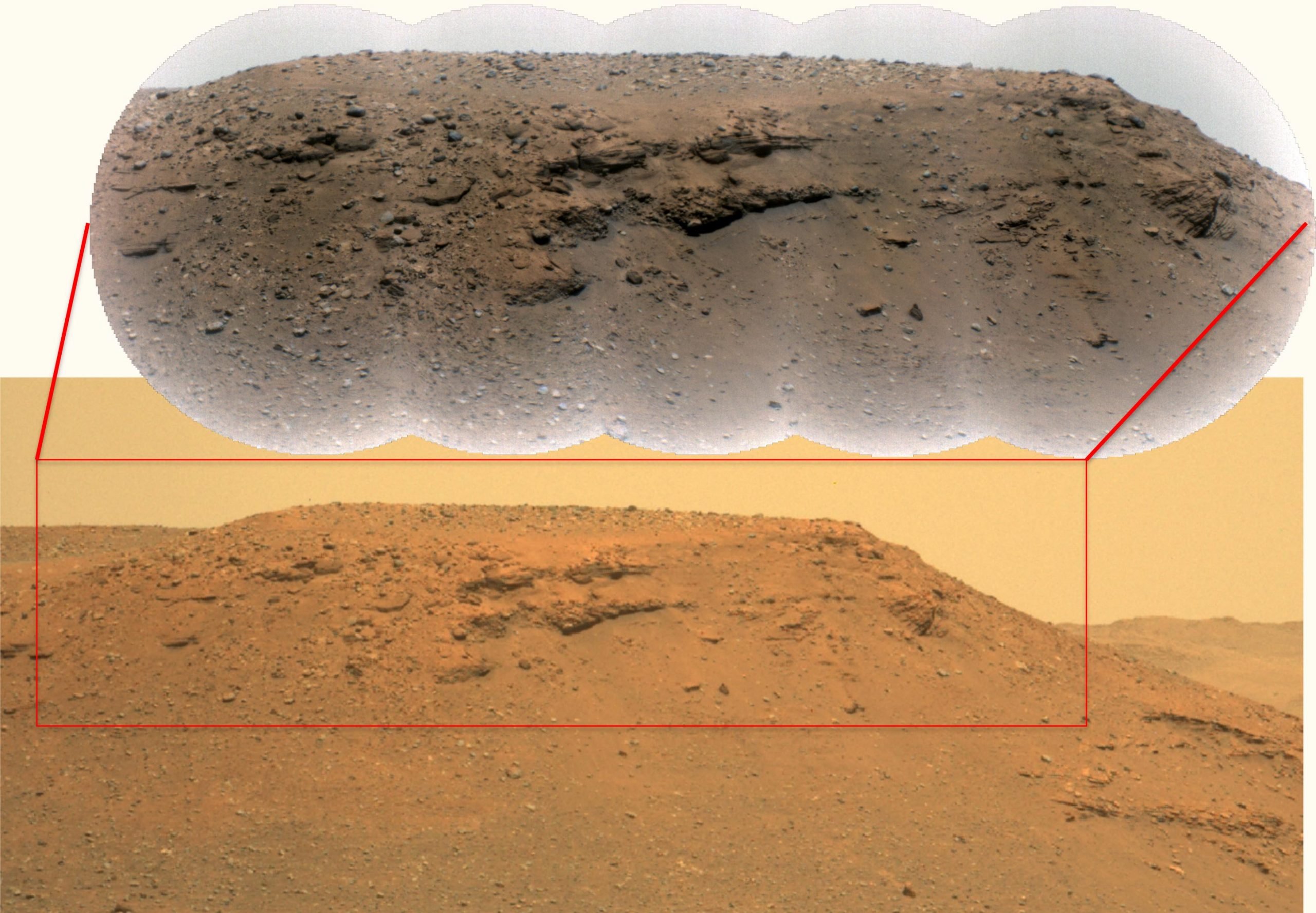
During this time, two of Perseverance’s cameras, Mastcam-Z and the SuperCam Remote Micro-Imager (RMI), captured images of their surroundings, including long-distance photos of the outcrop’s edge and a formation known as Kodiak butte, a smaller outcrop that planetary geologists surmise may have once been connected to the main fan-shaped outcrop but has since partially eroded.

Once the rover downlinked images to Earth, NASA’s Perseverance science team processed and combined the images, and were able to observe distinct beds of sediment along Kodiak butte in surprisingly high resolution. The researchers measured each layer’s thickness, slope, and lateral extent, finding that the sediment must have been deposited by flowing water into a lake, rather than by wind, sheet-like floods, or other geologic processes.
The rover also captured similar tilted sediment beds along the main outcrop. These images, together with those of Kodiak, confirm that the fan-shaped formation was indeed an ancient delta and that this delta fed into an ancient Martian lake.
“Without driving anywhere, the rover was able to solve one of the big unknowns, which was that this crater was once a lake,” Weiss says. “Until we actually landed there and confirmed it was a lake, it was always a question.”
Boulder Flow
When the researchers took a closer look at images of the main outcrop, they noticed large boulders and cobbles embedded in the youngest, topmost layers of the delta. Some boulders measured as wide as 1 meter across, and were estimated to weigh up to several tons. These massive rocks, the team concluded, must have come from outside the crater, and was likely part of bedrock located on the crater rim or else 40 or more miles upstream.
Judging from their current location and dimensions, the team says the boulders were carried downstream and into the lakebed by a flash-flood that flowed up to 9 meters (30 feet) per second and moved up to 3,000 cubic meters (800,000 gallons) of water per second.
“You need energetic flood conditions to carry rocks that big and heavy,” Weiss says. “It’s a special thing that may be indicative of a fundamental change in the local hydrology or perhaps the regional climate on Mars.”
Because the huge rocks lie in the upper layers of the delta, they represent the most recently deposited material. The boulders sit atop layers of older, much finer sediment. This stratification, the researchers say, indicates that for much of its existence, the ancient lake was filled by a gently flowing river. Fine sediments — and possibly organic material — drifted down the river, and settled into a gradual, sloping delta.
However, the crater later experienced sudden flash floods that deposited large boulders onto the delta. Once the lake dried up, and over billions of years wind eroded the landscape, leaving the crater we see today.
The cause of this climate turnaround is unknown, although Weiss says the delta’s boulders may hold some answers.
“The most surprising thing that’s come out of these images is the potential opportunity to catch the time when this crater transitioned from an Earth-like habitable environment, to this desolate landscape wasteland we see now,” he says. “These boulder beds may be records of this transition, and we haven’t seen this in other places on Mars.”
For more on this research, read NASA’s Mars Perseverance “Kodiak” Moment – Jezero Crater’s Lake Is More Complicated and Intriguing Than Thought.
Reference: “Perseverance rover reveals an ancient delta-lake system and flood deposits at Jezero crater, Mars” by N. Mangold, S. Gupta, O. Gasnault, G. Dromart, J. D. Tarnas, S. F. Sholes, B. Horgan, C. Quantin-Nataf, A. J. Brown, S. Le Mouélic, R. A. Yingst, J. F. Bell, O. Beyssac, T. Bosak, F. Calef III, B. L. Ehlmann, K. A. Farley, J. P. Grotzinger, K. Hickman-Lewis, S. Holm-Alwmark, L. C. Kah, J. Martinez-Frias, S. M. McLennan, S. Maurice, J. I. Nuñez, A. M. Ollila, P. Pilleri, J.W. Rice Jr., M. Rice, J. I. Simon, D. L. Shuster, K. M. Stack, V. Z. Sun, A. H. Treiman, B. P. Weiss, R. C. Wiens, A. J. Williams, N. R. Williams and K. H. Williford, 7 October 2021, Science.
DOI: 10.1126/science.abl4051
This research was supported, in part, by NASA.
Never miss a breakthrough: Join the SciTechDaily newsletter.
Follow us on Google and Google News.
6 Comments
Ok.. it’s an ancient lake with a delta. Wasn’t that why NASA chose it? Time to take a look at the sediments deposited in that lake, supposedly clays and muds that might house organic fossils?. The boulders should also be studied as they represent even older sediments eroded from still older rocks. What’s the delay? More landscape photos are needed to send “postcards” back home? The rover has all the tools…use them.
The references to life on Mars seem premature. Yes, there is evidence that a lake was there. No, there is no evidence of any life. Not yet. Why speculate that there was life?
Yeah, I mean why did we send a rover to Mars in the first place when we knew there was no evidence of any life there.
All these Mars photos are the biggest scam!look in the background, there are clouds drifting by,and the soil around the chunks of rock is wind blown.lots of desert on earth to film this bullsh*t!They even show an artists concept of 3 more rovers in Mars,aren’t they all computer simulated?So..you all beleive we can fly thru space and hit a moving target millions of miles away, not run out of fuel, and return to earth in the middle of the cosmos, another moving target.
The great Irish bullsh*t game is still on folks,and they just love pumping you with bullsh*t to see how gullible you are and how much they can get away with!…the brain accepts what it sees,phycology 101!
Or,they can’t quit trying to outdo the Russians,but news flash, the cold War s over!or for whatever game they are playing on the public,big waste of money, while people are starving and homeless on earth!
SO they can tale a picture of a paperclip, 1 fotballfield away, but the images we get to see, barely possible to zoom in at all. I’ve got better resolution on my 20 year old Nokia phone’s camera..
Considering that life was discovered on Mars by a NASA approved organic testing pod located on the Viking Lander in 1976, I cannot help but point out that NASA has been milking the Mars Cow for 45 years. Lets stop enabling NASA and make them come clean.