
Scientists from NASA’s Goddard Space Flight Center in Greenbelt, Maryland, and international collaborators demonstrated a new method for mapping the location and size of trees growing outside of forests, discovering billions of trees in arid and semi-arid regions and laying the groundwork for more accurate global measurement of carbon storage on land.
Using powerful supercomputers and machine learning algorithms, the team mapped the crown diameter – the width of a tree when viewed from above – of more than 1.8 billion trees across an area of more than 500,000 square miles, or 1,300,000 square kilometers. The team mapped how tree crown diameter, coverage, and density varied depending on rainfall and land use.
Mapping non-forest trees at this level of detail would take months or years with traditional analysis methods, the team said, compared to a few weeks for this study. The use of very high-resolution imagery and powerful artificial intelligence represents a technology breakthrough for mapping and measuring these trees. This study is intended to be the first in a series of papers whose goal is not only to map non-forest trees across a wide area, but also to calculate how much carbon they store – vital information for understanding the Earth’s carbon cycle and how it is changing over time.
Scientists from NASA’s Goddard Space Flight Center in Greenbelt, Maryland, and international collaborators demonstrated a new method for mapping the location and size of trees growing outside of forests, discovering surprisingly high numbers of trees in semi-arid regions and laying the groundwork for more accurate global measurement of carbon storage on land. Credit: NASA’s Goddard Space Flight Center
Measuring carbon in trees
Carbon is one of the primary building blocks for all life on Earth, and this element circulates among the land, atmosphere, and oceans via the carbon cycle. Some natural processes and human activities release carbon into the atmosphere, while other processes draw it out of the atmosphere and store it on land or in the ocean. Trees and other green vegetation are carbon “sinks,” meaning they use carbon for growth and store it out of the atmosphere in their trunks, branches, leaves and roots. Human activities, like burning trees and fossil fuels or clearing forested land, release carbon into the atmosphere as carbon dioxide, and rising concentrations of atmospheric carbon dioxide are a main cause of climate change.
Conservation experts working to mitigate climate change and other environmental threats have targeted deforestation for years, but these efforts do not always include trees that grow outside forests, said Compton Tucker, senior biospheric scientist in the Earth Sciences Division at NASA Goddard. Not only could these trees be significant carbon sinks, but they also contribute to the ecosystems and economies of nearby human, animal, and plant populations. However, many current methods for studying trees’ carbon content only include forests, not trees that grow individually or in small clusters.
Tucker and his NASA colleagues, together with an international team, used commercial satellite images from DigitalGlobe, which were high-resolution enough to spot individual trees and measure their crown size. The images came from the commercial QuickBird-2, GeoEye-1, WorldView-2, and WorldView-3 satellites. The team focused on the dryland regions – areas that receive less precipitation than what evaporates from plants each year – including the arid south side of the Sahara Desert, which stretches through the semi-arid Sahel Zone and into the humid sub-tropics of West Africa. By studying a variety of landscapes from few trees to nearly forested conditions, the team trained their computing algorithms to recognize trees across diverse terrain types, from deserts in the north to tree savannas in the south.
Learning on the job
The team ran a powerful computing algorithm called a fully convolutional neural network (“deep learning”) on the University of Illinois’ Blue Waters, one of the world’s fastest supercomputers. The team trained the model by manually marking nearly 90,000 individual trees across a variety of terrain, then allowing it to “learn” which shapes and shadows indicated the presence of trees.
The process of coding the training data took more than a year, said Martin Brandt, an assistant professor of geography at the University of Copenhagen and the study’s lead author. Brandt marked all 89,899 trees by himself and helped supervise training and running the model. Ankit Kariryaa of the University of Bremen led the development of the deep-learning computer processing.
“In one kilometer of terrain, say it’s a desert, many times there are no trees, but the program wants to find a tree,” Brandt said. “It will find a stone, and think it’s a tree. Further south, it will find houses that look like trees. It sounds easy, you’d think – there’s a tree, why shouldn’t the model know it’s a tree? But the challenges come with this level of detail. The more detail there is, the more challenges come.”
Establishing an accurate count of trees in this area provides vital information for researchers, policymakers, and conservationists. Additionally, measuring how tree size and density vary by rainfall – with wetter and more populated regions supporting more and larger trees – provides important data for on-the-ground conservation efforts.
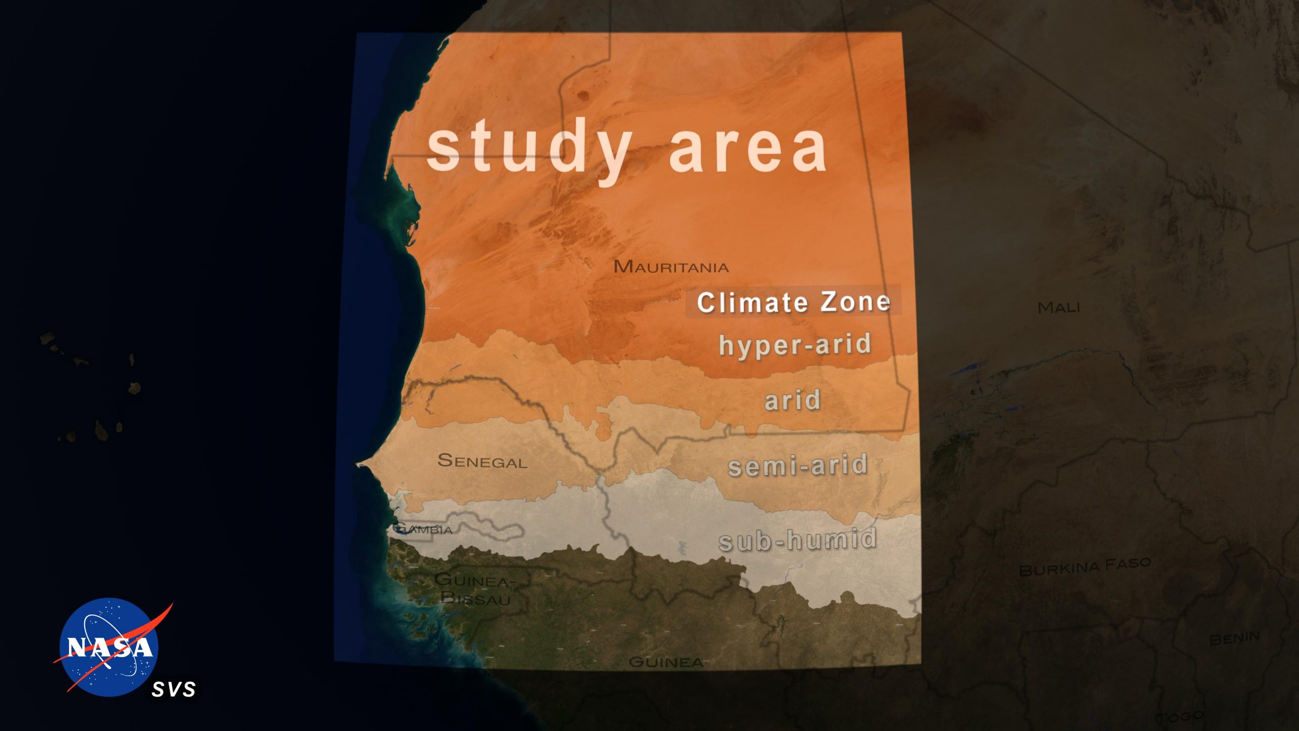
The visualization starts at a global scale then pushes in to show the study area. To illustrate that this is a dry area, climate zones are shown using annual rainfall averages from 1982-2017 including regions that are: hyper-arid (0-150 mm rainfall/year), arid (150-300 mm/year), semi-arid (300-600 mm/year), sub-humid (600-1000 mm/year). We then zoom in to a semi-arid area in Senegal down to a point where we can see individual trees. The visualization next shows an area of high resolution imagery of the trees, then overlays the results of the machine learning which are filled regions of tree crowns for each tree in view. The trees are then counted up. The areas of trees are also totaled using the tree crown regions. We then zoom back out to see the entire study area and the total tree count and area. Credit: NASA’s Scientific Visualization Studio
“There are important ecological processes, not only inside, but outside forests too,” said Jesse Meyer, a programmer at NASA Goddard who led the processing on Blue Waters. “For preservation, restoration, climate change, and other purposes, data like these are very important to establish a baseline. In a year or two or ten, the study could be repeated with new data and compared to data from today, to see if efforts to revitalize and reduce deforestation are effective or not. It has quite practical implications.”
After gauging the program’s accuracy by comparing it to both manually coded data and field data from the region, the team ran the program across the full study area. The neural network identified more than 1.8 billion trees – surprising numbers for a region often assumed to support little vegetation, said Meyer and Tucker.
“Future papers in the series will build on the foundation of counting trees, extend the areas studied, and look for ways to calculate their carbon content,” said Tucker. NASA missions like the Global Ecosystem Dynamics Investigation mission, or GEDI, and ICESat-2, or the Ice, Cloud, and Land Elevation Satellite-2, are already collecting data that will be used to measure the height and biomass of forests. In the future, combining these data sources with the power of artificial intelligence could open up new research possibilities.
“Our objective is to see how much carbon is in isolated trees in the vast arid and semi-arid portions of the world,” Tucker said. “Then we need to understand the mechanism which drives carbon storage in arid and semi-arid areas. Perhaps this information can be utilized to store more carbon in vegetation by taking more carbon dioxide out of the atmosphere.”
“From a carbon cycle perspective, these dry areas are not well mapped, in terms of what density of trees and carbon is there,” Brandt said. “It’s a white area on maps. These dry areas are basically masked out. This is because normal satellites just don’t see the trees – they see a forest, but if the tree is isolated, they can’t see it. Now we’re on the way to filling these white spots on the maps. And that’s quite exciting.”
Reference: “An unexpectedly large count of trees in the West African Sahara and Sahel” by Martin Brandt, Compton J. Tucker, Ankit Kariryaa, Kjeld Rasmussen, Christin Abel, Jennifer Small, Jerome Chave, Laura Vang Rasmussen, Pierre Hiernaux, Abdoul Aziz Diouf, Laurent Kergoat, Ole Mertz, Christian Igel, Fabian Gieseke, Johannes Schöning, Sizhuo Li, Katherine Melocik, Jesse Meyer, Scott Sinno, Eric Romero, Erin Glennie, Amandine Montagu, Morgane Dendoncker and Rasmus Fensholt, 14 October 2020, Nature.
DOI: 10.1038/s41586-020-2824-5
Never miss a breakthrough: Join the SciTechDaily newsletter.
Follow us on Google and Google News.
19 Comments
Like the resources using deep computer learning to map tree around the world. To think @90,000 trees were actually mapped out so that computers could learn to recognize a tree. Is there a cross reference of return on investment, or return on water input to carbon capture of specific tree species (I.e. Mesquite versus Cottonwood trees)? Would it make more carbon to start a forest in a desert, a temperate, or tropical climate? Does carbon sequestration correlate to wood production in all species?
How much carbon does urban trees absorb, yard trees all combined in each city. How much oxygeon do they emit. And will bushes, shrubs and plants, even grass be measured and analyzed and measured for each city, region, state, country, and even block.?
Now some rich f*** will come along and destroy it.
I have always loved trees. THE most precious things on earth.
We lost too many by deforestation…
The wisdom is in the trees not the glass windows – Jack Johnson.
All the work by NASA especially the CARBON study is also vital to small rural areas like where I live in Northeastern Oklahoma where burning of any kind of tree is concerning our lack of environmental impact. Now we should begin to study what deforestation will cause for us.
Thank you for sharing this vital study for us to become more intelligent especially how globall warming is influenced by carbon and levels of carbon dioxide!
Could this super computer change to hacking votes in the election?
Biggest rigged election in American history. Trump won by a landslide I cannot believe this is where I live
You have provided as much evidence as Trump’s legal team. Zero. That’s because just being a sore LOSER isn’t actual evidence of anything, other than a frail ego. Trump lost because of his base, who refused to wear masks…and COVID surging because of it tanked his chances. In trying to be a pain to Dems, the dense base sank their own re-election, and now need someone to blame other than themselves. That super bright Trump base didn’t think those actions through, but then again they don’t look long-term, like Trump….it’s only about today, even if it burns you tomorrow. Sleep in the bed you made.
No. Obviously.
So all the sky is falling, death in 12 year models were touted without even knowing how much carbon is being stored and increased due to growth?
@nasa, if people don’t know about them they won’t be able to cut them all down – constant battles to save the rainforest, now we will have to save the desert forest
#shame
So many people are wondering too. I was about to NASA if we live without trees..then must be living inside the skeleton of some unique trees still working on their analysis
Thank you NASA, for informative study. amazing that there is new growth in an arid climate. Perhaps the desert sands are sifting the salt content, causing a purified spring that nurtures new plant life.
Who owns the land and how it will it be protected?
In an Alabama National Forest i saw trees so thick there was no trail through. When the south looked like that a Hurricane was no threat.In the White Sands NM. Desert a tent can’t be used because a 20+ MPH wind blows all night. No Trees to stop wind. This year in SE. Pennsylvania heavy winds are happening. Maybe too many trees have been cut down for housing. development. The problem is oversized houses. Unoccupied 2nd houses.Increased asphalt road surface. But those conditions are what we call our rights. We are the problem!
We are an out of control virus taking over and destroying the planet.. But its, you know…. like whatever.
Humans are not a virus, we are mammals who are as much a part of the natural world as a bird in the sky or a beaver in the stream.Sometimes it’s better to refrain from interjecting senselessness when you don’t know the subject matter.