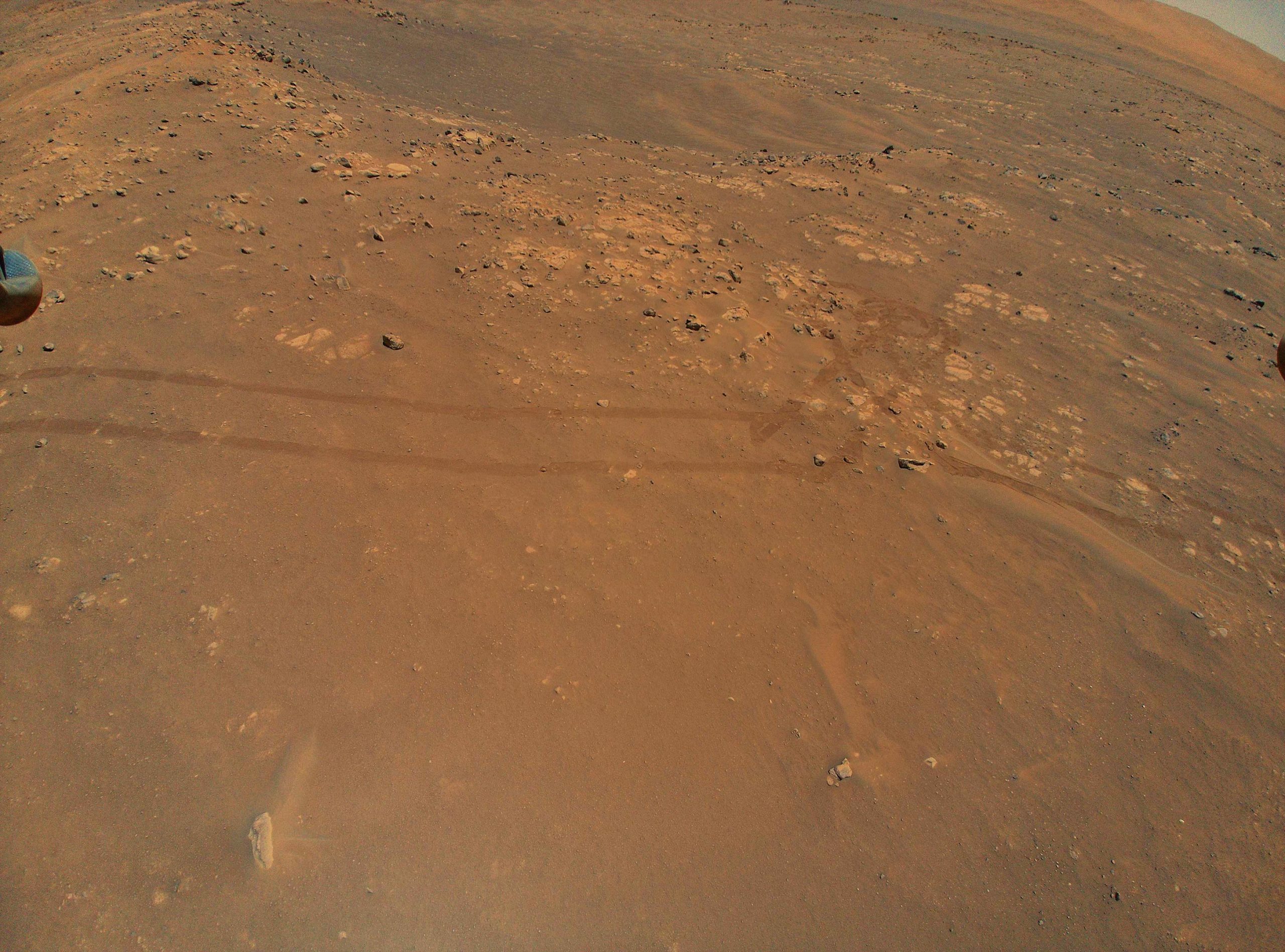
NASA’s Ingenuity Mars Helicopter captured this image of tracks made by the Perseverance rover during its ninth flight, on July 5. A portion of the helicopter’s landing gear can be seen at top left. Credit: NASA/JPL-Caltech
Ingenuity’s ninth flight provided imagery that will help the Perseverance rover team develop its science plan going forward.
Images snapped on July 5 by NASA’s Ingenuity Mars Helicopter on its ambitious ninth flight have offered scientists and engineers working with the agency’s Perseverance Mars rover an unprecedented opportunity to scout out the road ahead. Ingenuity provided new insight into where different rock layers begin and end, each layer serving as a time capsule for how conditions in the ancient climate changed at this location. The flight also revealed obstacles the rover may have to drive around as it explores Jezero Crater.
During the flight – designed to test the helicopter’s ability to serve as an aerial scout – Ingenuity soared over a dune field nicknamed “Séítah.” Perseverance is making a detour south around those dunes, which would be too risky for the six-wheeled rover to try crossing.
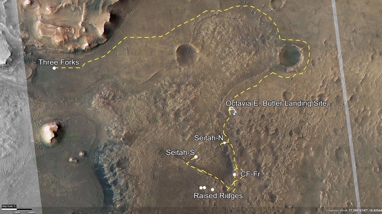
This annotated image of Jezero Crater depicts the routes for Perseverance’s first science campaign (yellow hash marks) as well as its second (light-yellow hash marks). Credit: NASA/JPL-Caltech/University of Arizona
The color images from Ingenuity, taken from a height of around 33 feet (10 meters), offer the rover team much greater detail than they get from the orbiter images (such as the one above) they typically use for route planning. While a camera like HiRISE (the High Resolution Imaging Science Experiment) aboard NASA’s Mars Reconnaissance Orbiter can resolve rocks about 3 feet (1 meter) in diameter, missions usually rely on rover images to see smaller rocks or terrain features.
“Once a rover gets close enough to a location, we get ground-scale images that we can compare to orbital images,” said Perseverance Deputy Project Scientist Ken Williford of NASA’s Jet Propulsion Laboratory in Southern California. “With Ingenuity, we now have this intermediate-scale imagery that nicely fills the gap in resolution.”
Below are a few of Ingenuity’s images, which completed the long journey back to Earth on July 8.
Raised Ridges
Ingenuity (its shadow is visible at the bottom of this image) offered a high-resolution glimpse of rock features nicknamed “Raised Ridges.” They belong to a fracture system, which often serve as pathways for fluid to flow underground.

NASA’s Ingenuity Mars Helicopter spotted this location, nicknamed “Raised Ridges,” during its ninth flight, on July 5. Scientists hope to visit “Raised Ridges” with the Perseverance rover in the future. Credit: NASA/JPL-Caltech
Here in Jezero Crater, a lake existed billions of years ago. Spying the ridges in images from Mars orbiters, scientists have wondered whether water might have flowed through these fractures at some point, dissolving minerals that could help feed ancient microbial colonies. That would make them a prime location to look for signs of ancient life – and perhaps to drill a sample.
The samples Perseverance takes will eventually be deposited on Mars for a future mission that would take them to Earth for in-depth analysis.
“Our current plan is to visit Raised Ridges and investigate it close up,” Williford said. “The helicopter’s images are by far better in resolution than the orbital ones we were using. Studying these will allow us to ensure that visiting these ridges is important to the team.”
Dunes
Sand dunes like the ones in this image keep rover drivers like JPL’s Olivier Toupet awake at night: Knee- or waist-high, they could easily cause the two-ton rover to get stuck. After landing in February, Perseverance scientists asked whether it was possible to make a beeline across this terrain; Toupet’s answer was a hard no.
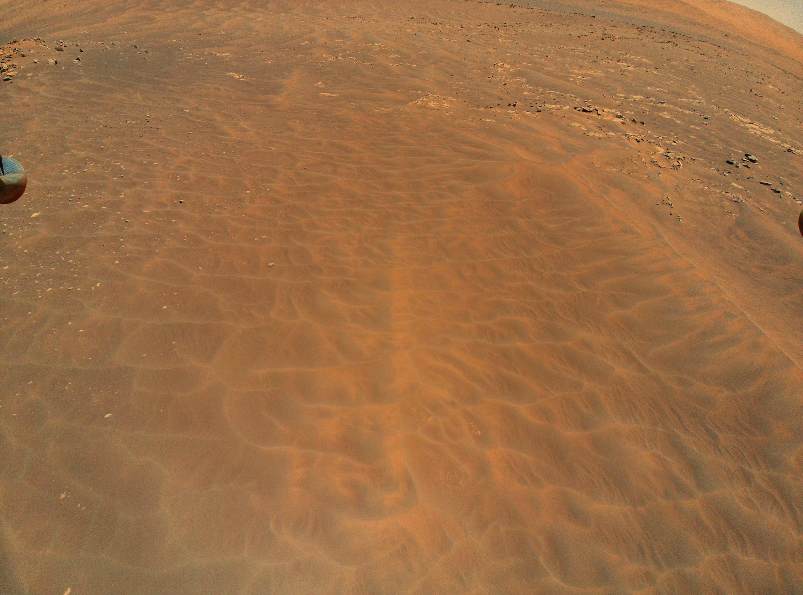
NASA’s Ingenuity Mars Helicopter flew over this dune field in a region of Jezero Crater nicknamed “Séítah” during its ninth flight, on July 5, 2021. A portion of the helicopter’s landing gear can be seen at top left. Credit: NASA/JPL-Caltech
“Sand is a big concern,” said Toupet, who leads the team of mobility experts that plans Perseverance’s drives. “If we drive downhill into a dune, we could embed ourselves into it and not be able to get back out.”
Toupet is also the lead for Perseverance’s newly tested AutoNav feature, which uses artificial intelligence algorithms to drive the rover autonomously over greater distances than could be achieved otherwise. While good at avoiding rocks and other hazards, AutoNav can’t detect sand, so human drivers still need to define “keep-out zones” around areas that could entrap the rover.
Bedrock
Without Ingenuity, visible in silhouette at the bottom of this next image, Perseverance’s scientists would never get to see this section of Séítah so clearly: It’s too sandy for Perseverance to visit. The unique view offers enough detail to inspect these rocks and get a better understanding of this area of Jezero Crater.
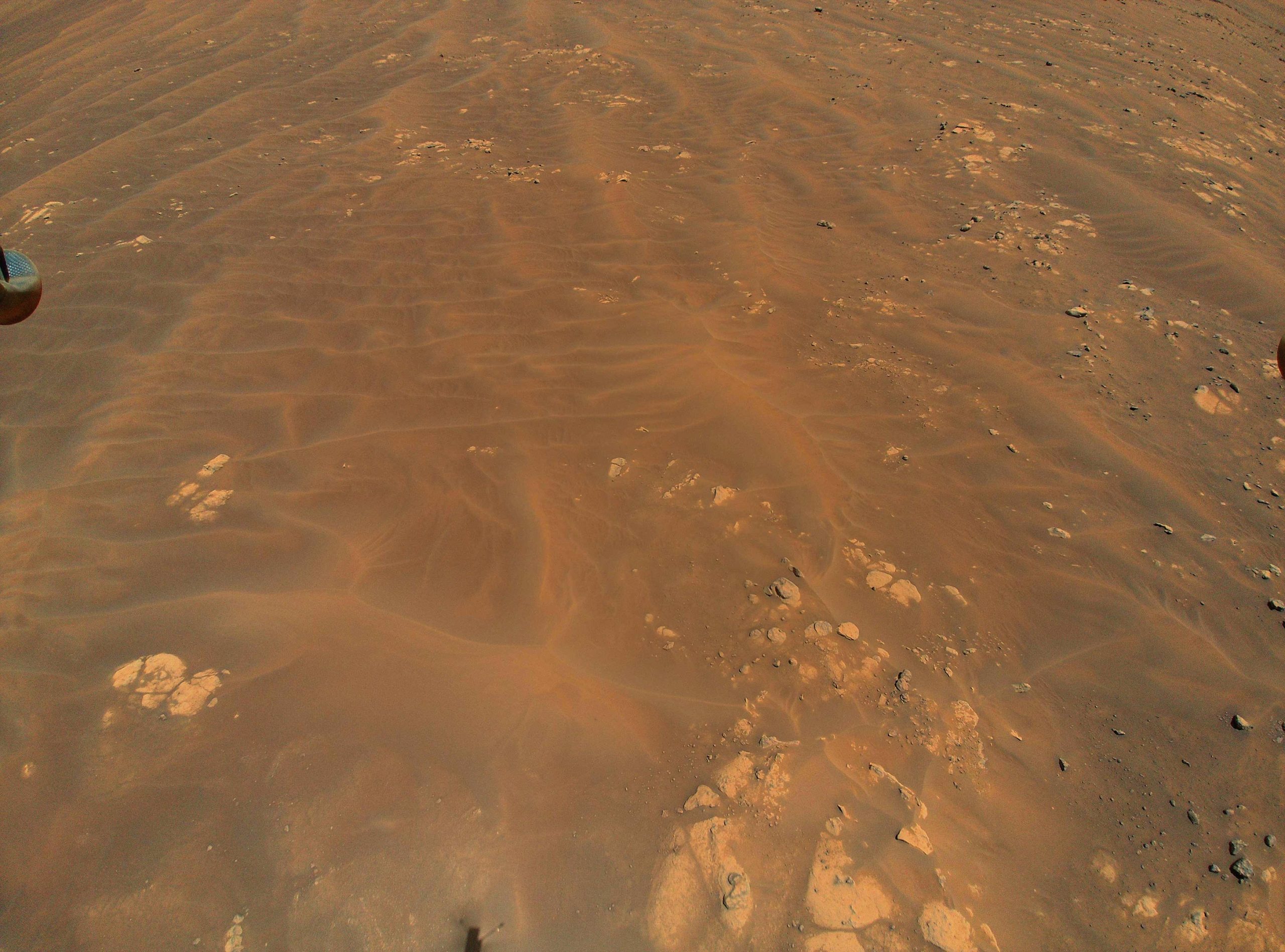
NASA’s Ingenuity Mars Helicopter flew over these sand dunes and rocks during its ninth flight, on July 5, 2021. While the agency’s Perseverance Mars can’t risk getting stuck in this sand, scientists are still able to learn about this region by studying it from Ingenuity’s images. Credit: NASA/JPL-Caltech
As the rover works its way around the dune field, it may make what the team calls a “toe dip” into some scientifically compelling spots with interesting bedrock. While Toupet and his team wouldn’t attempt a toe dip here, the recent images from Ingenuity will allow them to plan potential toe-dip paths in other regions along the route of Perseverance’s first science campaign.
“The helicopter is an extremely valuable asset for rover planning because it provides high-resolution imagery of the terrain we want to drive through,” said Toupet. “We can better assess the size of the dunes and where bedrock is poking out. That’s great information for us; it helps identify which areas may be traversable by the rover and whether certain high-value science targets are reachable.”
More About the Mission
A key objective for Perseverance’s mission on Mars is astrobiology, including the search for signs of ancient microbial life. The rover will characterize the planet’s geology and past climate, pave the way for human exploration of the Red Planet, and be the first mission to collect and cache Martian rock and regolith (broken rock and dust).
Subsequent NASA missions, in cooperation with ESA (European Space Agency), would send spacecraft to Mars to collect these sealed samples from the surface and return them to Earth for in-depth analysis.
The Mars 2020 Perseverance mission is part of NASA’s Moon to Mars exploration approach, which includes Artemis missions to the Moon that will help prepare for human exploration of the Red Planet.
JPL, which is managed for NASA by Caltech in Pasadena, California, built and manages operations of the Perseverance rover.
The Ingenuity Mars Helicopter was built by JPL, which also manages the technology demonstration project for NASA Headquarters. It is supported by NASA’s Science, Aeronautics Research, and Space Technology mission directorates. NASA’s Ames Research Center in California’s Silicon Valley, and NASA’s Langley Research Center in Hampton, Virginia, provided significant flight performance analysis and technical assistance during Ingenuity’s development. AeroVironment Inc., Qualcomm, and SolAero also provided design assistance and major vehicle components. Lockheed Martin Space designed and manufactured the Mars Helicopter Delivery System.
JPL manages the MRO mission for NASA’s Science Mission Directorate in Washington. The University of Arizona, in Tucson, operates HiRISE, which was built by Ball Aerospace & Technologies Corp., in Boulder, Colorado.


Mars helicopter and Perseverance rover are conjugate parts now for Mars exploration mission.
Two successful parts of unique mars mission are mars helicopter and Perseverance rover.
Egyptian archeologists use satellite to search for structure hidden underneath the sand and have been successful. Can this technology be use to search for structures under the sand that are not natural but built by intelligent life?
Egyptian archeologists use satellite to search for structure hidden underneath the sand and have been successful. Can this technology be use on Mars to search for structures under the sand (dunes) that are not natural but built by intelligent life?
In the top right-hand corner of the dunes image, there is what appears to be a large, perfectly spherical object with a smooth surface which reflects light and possibly has holes in. Would be very interesting if Perseverance could investigate this anomaly, even just to prove it is natural.
The image with the helicopter shadow has a large upright septre with a trapezoidal head, above the shadow (therefore larger than the helicopter) sticking out of the ground
It’s all fakery…wake up. There is no outer space. They are on some desert on earth. Give me a break. How gullible can the masses me?
“There is no outer space… Give me a break. How gullible can the masses me?”
If you want a “break,” you could quit trolling this site.
After staring at this spot in the sand of mars for Two hours straight I’m sure its a carving or a mask Of Biden or maybe …? My ex?
I want some of ur smoke bro! Space is Fake wow that’s a first! Strange theory or myth…
Nasa ingenuity helicopter & prescience River mission a great successive mission in the Mars. Its created an advanced available new mission through NASA & could be more helpful to know about Mars inside including alen.
We congratulate NASA to that success & to know immifiate more advancement.