
Discover how the upcoming U.S.-India NISAR mission is set to revolutionize our understanding of Earth with its unique dual-band radar technology. This collaborative satellite will capture detailed changes in the planet’s surface, from forest growth to glacier movements, offering unprecedented data for both scientific research and practical applications in disaster response and environmental monitoring.
A Q&A with the lead U.S. scientist of the mission, which will track changes in everything from wetlands to ice sheets to infrastructure damaged by natural disasters.
The U.S.-India NISAR (NASA-ISRO Synthetic Aperture Radar) mission is set to revolutionize Earth observation, providing unprecedented insights into our planet’s dynamic and ever-changing surface.
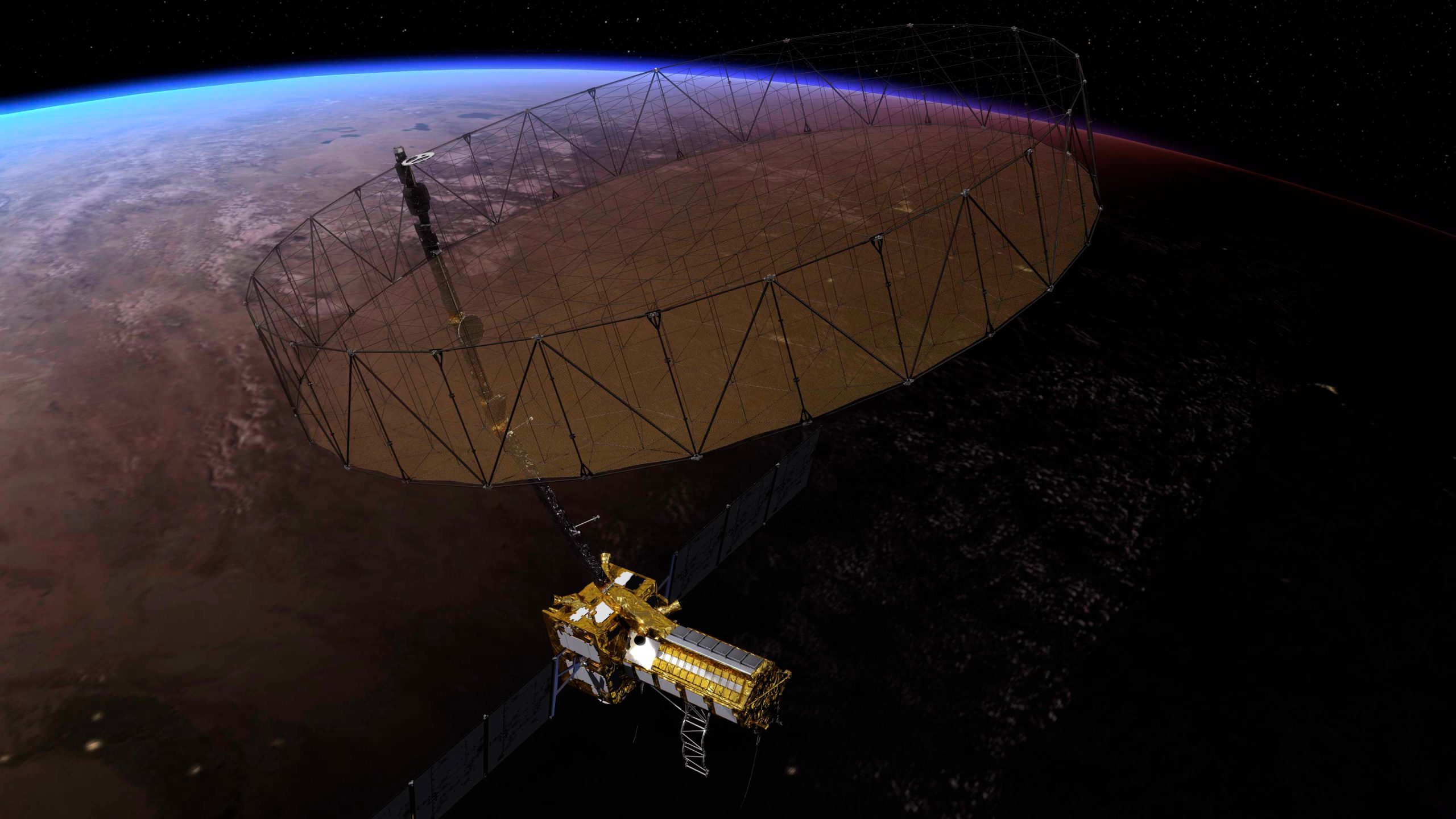
NISAR is the first satellite of its kind, equipped with dual-band radar technology. It will measure land deformation caused by earthquakes, landslides, and volcanoes, delivering critical data for both scientific research and disaster response. The satellite will also track the movement of glaciers and ice sheets, monitor forest and wetland changes, and offer valuable insights into the global carbon cycle.
Beyond its scientific potential, NISAR’s journey to launch has been equally remarkable. With the mission just months away, Paul Rosen, the project scientist at NASA’s Jet Propulsion Laboratory (JPL) in California, reflected on the mission’s significance and what makes it truly unique.

How will NISAR improve our understanding of Earth?
The planet’s surfaces never stop changing — in some ways small and subtle, and in other ways monumental and sudden. With NISAR, we’ll measure that change roughly every week, with each pixel capturing an area about half the size of a tennis court. Taking imagery of nearly all Earth’s land and ice surfaces this frequently and at such a small scale — down to the centimeter — will help us put the pieces together into one coherent picture to create a story about the planet as a living system.
What sets NISAR apart from other Earth missions?
NISAR will be the first Earth-observing satellite with two kinds of radar — an L-band system with a 10-inch (25-centimeter) wavelength and an S-band system with a 4-inch (10-centimeter) wavelength.
Whether microwaves reflect or penetrate an object depends on their wavelength. Shorter wavelengths are more sensitive to smaller objects such as leaves and rough surfaces, whereas longer wavelengths are more reactive with larger structures like boulders and tree trunks.
So NISAR’s two radar signals will react differently to some features on Earth’s surface. By taking advantage of what each signal is or isn’t sensitive to, researchers can study a broader range of features than they could with either radar on its own, observing the same features with different wavelengths.

Is this new technology?
The concept of a spaceborne synthetic aperture radar, or SAR, studying Earth’s processes dates to the 1970s, when NASA launched Seasat. Though the mission lasted only a few months, it produced first-of-a-kind images that changed the remote-sensing landscape for decades to come.
It also drew me to JPL in 1981 as a college student: I spent two summers analyzing data from the mission. Seasat led to NASA’s Shuttle Imaging Radar program and later to the Shuttle Radar Topography Mission.
What will happen to the data from the mission?
Our data products will fit the needs of users across the mission’s science focus areas — ecosystems, cryosphere, and solid Earth — plus have many uses beyond basic research like soil-moisture and water resources monitoring.
We’ll make the data easily accessible. Given the volume of the data, NASA decided that it would be processed and stored in the cloud, where it’ll be free to access.
How did the ISRO partnership come about?
We proposed DESDynI (Deformation, Ecosystem Structure, and Dynamics of Ice), an L-band satellite, following the 2007 Decadal Survey by the National Academy of Sciences. At the time, ISRO was exploring launching an S-band satellite. The two science teams proposed a dual-band mission, and in 2014 NASA and ISRO agreed to partner on NISAR.
Since then, the agencies have been collaborating across more than 9,000 miles (14,500 kilometers) and 13 time zones. Hardware was built on different continents before being assembled in India to complete the satellite. It’s been a long journey — literally.
More About NISAR
The NASA-ISRO Synthetic Aperture Radar (NISAR) mission is a groundbreaking collaboration between the United States and India, marking the first time NASA and ISRO have jointly developed hardware for an Earth-observing satellite. Designed to revolutionize how we monitor and understand Earth’s surface changes, NISAR will provide critical data for scientific research, environmental monitoring, and disaster response.
Key Contributions from NASA
Managed by Caltech, with the Jet Propulsion Laboratory (JPL) leading the U.S. efforts, NASA has developed the mission’s L-band Synthetic Aperture Radar (SAR). NASA also contributed several key components:
- A radar reflector antenna
- A deployable boom
- A high-rate communication subsystem for transmitting science data
- GPS receivers
- A solid-state recorder
- The payload data subsystem
Key Contributions from ISRO
India’s Space Applications Centre (SAC) in Ahmedabad spearheaded the development of the S-band SAR instrument, ensuring its calibration, data processing, and science algorithms align with the mission’s goals. Other ISRO contributions include:
- The spacecraft bus, developed by the U R Rao Satellite Centre in Bengaluru
- The launch vehicle, provided by the Vikram Sarabhai Space Centre
- Launch services through the Satish Dhawan Space Centre
- Satellite mission operations are managed by the ISRO Telemetry Tracking and Command Network
- National Remote Sensing Centre (NRSC) in Hyderabad, responsible for S-band data reception, operational products, and dissemination
A Collaborative Vision
NISAR’s development underscores the complementary expertise of NASA and ISRO, with each agency contributing specialized technologies and infrastructure. This collaboration enables the mission to achieve its ambitious goal: to provide unprecedented data on Earth’s surface changes, including land deformation, ice-sheet dynamics, and ecosystem changes, ultimately enhancing our understanding of the planet’s evolving systems.
Never miss a breakthrough: Join the SciTechDaily newsletter.
Follow us on Google and Google News.