New Mars Express images show grooves, ridges, and crater patterns carved by ancient glaciers. These icy flows once reached well into Mars’s mid-latitudes, far from the poles.
Their presence reveals powerful climate shifts driven by changes in the planet’s tilt. Together, these features offer one of the clearest records of Mars’s icy past.
Tracing Ancient Terrain in Coloe Fossae
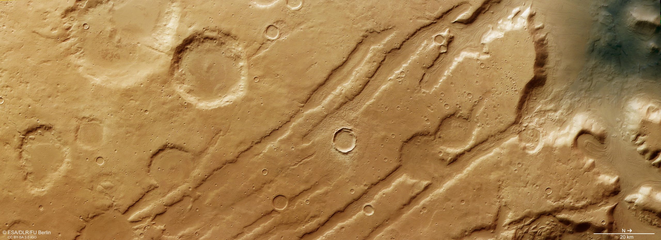
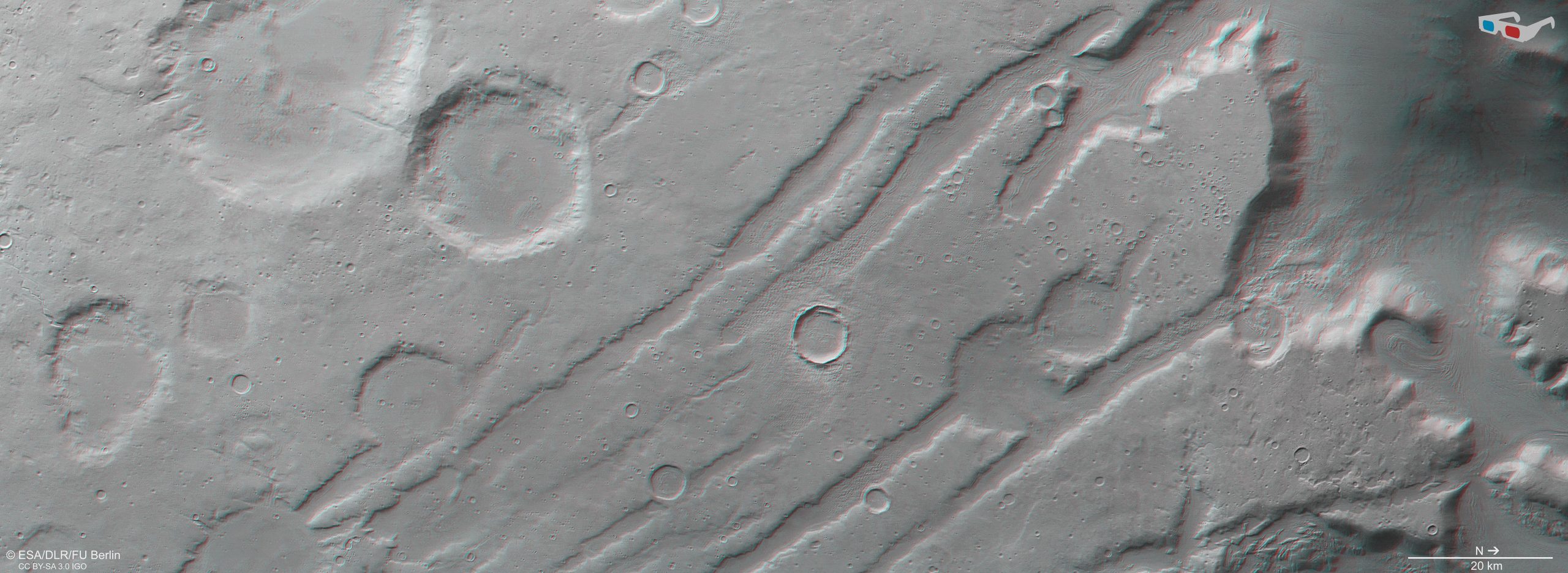
As we travel from Mars’s equator toward the planet’s northern regions, we arrive at Coloe Fossae. This landscape is characterized by long, shallow grooves that cut across an area filled with steep valleys, scattered impact craters, and surface clues left behind by an ancient ice age.
Ice Ages on Earth and Across the Solar System
Earth has gone through several ice ages over the past 2.5 billion years. The most recent one, which reached its peak roughly 20,000 years ago, lowered Earth’s global average temperature to around 7–10 °C (up to 8 °C cooler than today).
These long-term freezes differ completely from today’s human-driven warming trend. Ice ages arise from slow, natural cycles tied to shifts in a planet’s orbit around the Sun and changes in the tilt of its rotational axis. When an ice age begins, glaciers and ice sheets expand, and as temperatures fluctuate, these ice masses repeatedly advance and retreat.
Other planets show similar patterns. Mars carries its own evidence, and the newest views from the High Resolution Stereo Camera on ESA’s Mars Express reveal how strongly these cold periods shaped the planet.
Geological Clues Etched Into the Martian Surface
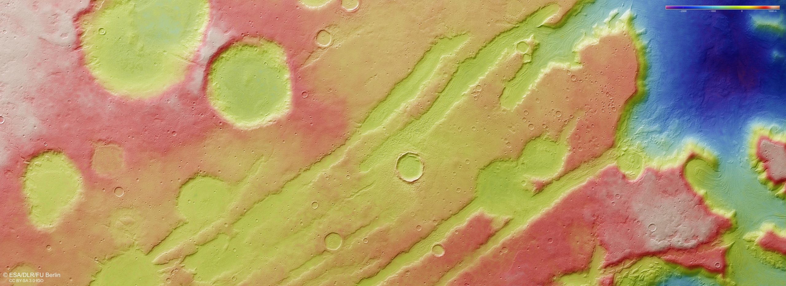
In the images, a set of nearly parallel lines cuts diagonally across the terrain. These features are Coloe Fossae, formed as alternating blocks of the crust dropped downward over time. The surrounding landscape contains numerous craters created by cosmic impacts. They vary widely in shape, size, and age, with some sharply defined, others eroded, and many overlapping or clustered together.
Within the valleys and crater floors lies something especially revealing: swirling, textured patterns that show where icy material once moved during a past martian ice age.
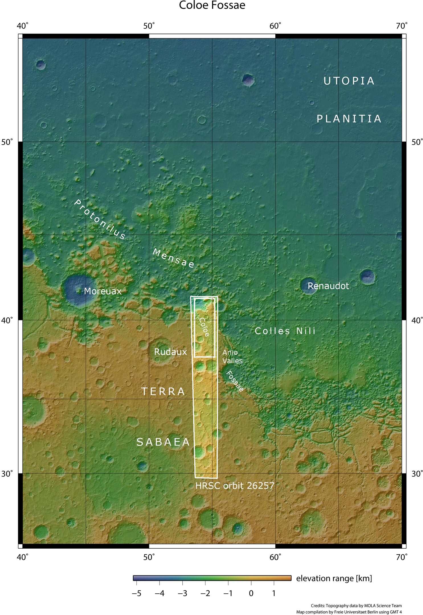
The area outlined by the larger white box indicates the area imaged by the High Resolution Stereo Camera (HRSC) aboard ESA’s Mars Express orbiter on October 19, 2024 (orbit 26257), while the smaller white box within shows the part of the surface featured in new images released in November 2025.
Credit: NASA/MGS/MOLA Science Team
Icy Flows and Glacial Deposits on Mars
These patterns provide direct clues to Mars’s earlier climate. Scientists classify them as lineated valley fill (in valleys) or concentric crater fill (in craters). They formed when slow-moving mixtures of ice and debris crept across the landscape – much like glaciers on Earth – and were eventually buried beneath thicker layers of rocky material.
This raises a surprising question, because the region sits at a latitude of 39°N. It is far from Mars’s north pole (at 90°N), so why did ice accumulate here?
Glaciers Driven by Mars’s Shifting Tilt
The explanation lies in Mars’s long cycle of advancing and retreating glaciers. Although the planet is dry today, it has gone through alternating warm and cold phases throughout its history. These shifts, driven mainly by changes in the tilt of its axis, caused repeated episodes of freezing and thawing.
During colder intervals, ice spread from both poles into the mid-latitudes. When the climate warmed again, the ice retreated but left behind clear geological traces. Lineated valley fill and concentric crater fill appear across this entire latitude range, indicating that the planet experienced a significant global climate shift. This region may even have been coated in ice as recently as half a million years ago, marking the end of Mars’s most recent ice age.
Mapping the Boundary Between Martian Terrains
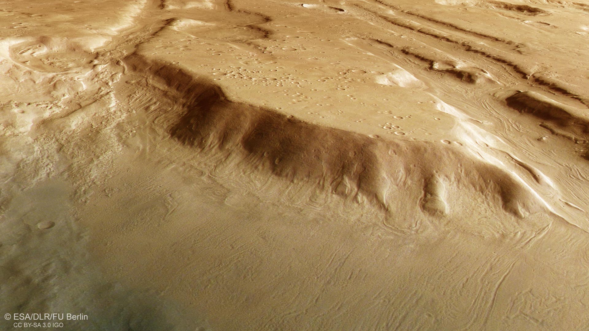
These features, along with Coloe Fossae and the nearby craters, are highlighted in the annotated imagery. The broader maps also show the division between Mars’s northern and southern terrains. This divide wraps around the entire planet; in some areas it forms a steep cliff nearly two kilometers high, while in others, including this region, it appears as a wide transitional zone that has been broken apart over time (known as Protonilus Mensae).
How the Images Were Produced
The Mars Express High Resolution Stereo Camera (HRSC) was developed and is operated by the German Aerospace Center (Deutsches Zentrum für Luft- und Raumfahrt; DLR). The systematic processing of its data took place at the DLR Institute of Planetary Research in Berlin-Adlershof. The working group of Planetary Science and Remote Sensing at Freie Universität Berlin created the final image products presented here.
Never miss a breakthrough: Join the SciTechDaily newsletter.
Follow us on Google and Google News.
1 Comment
“These long-term freezes differ completely from today’s human-driven warming trend. Ice ages arise from slow, natural cycles tied to shifts in a planet’s orbit around the Sun and changes in the tilt of its rotational axis.”
How can NASA be sure that our current warming isn’t at least partially the result of astronomical cycles that are causing warming? After all, the Holocene, the current geological epoch, is considered to be a warm interglacial, with the expectation that eventually Earth will experience yet another glaciation. One has to understand that neither ‘hot-house’ or ‘ice-house,’ or the average, are the normal state of affairs. Climate is always changing.