The Los Angeles area faces devastating fires exacerbated by dry conditions and Santa Ana winds, with the Palisades and Eaton fires drawing significant attention due to their rapid spread and the substantial efforts by NASA and local agencies to monitor and contain them.
Satellite imagery from NASA’s Terra and Aqua satellites provided crucial data, showing the extent of the smoke plumes and the fires’ progression over several days. Despite some initial containment, forecasted strong winds threatened to intensify the situation further.
Fiery Onset in Los Angeles
In January 2025, destructive wildfires swept through the Los Angeles area, driven by a dry landscape and strong Santa Ana winds. Among the most significant were the Palisades and Eaton fires, which ignited on January 7. Smoke from these fires was visible in satellite imagery for several days as fierce winds fueled their rapid spread.
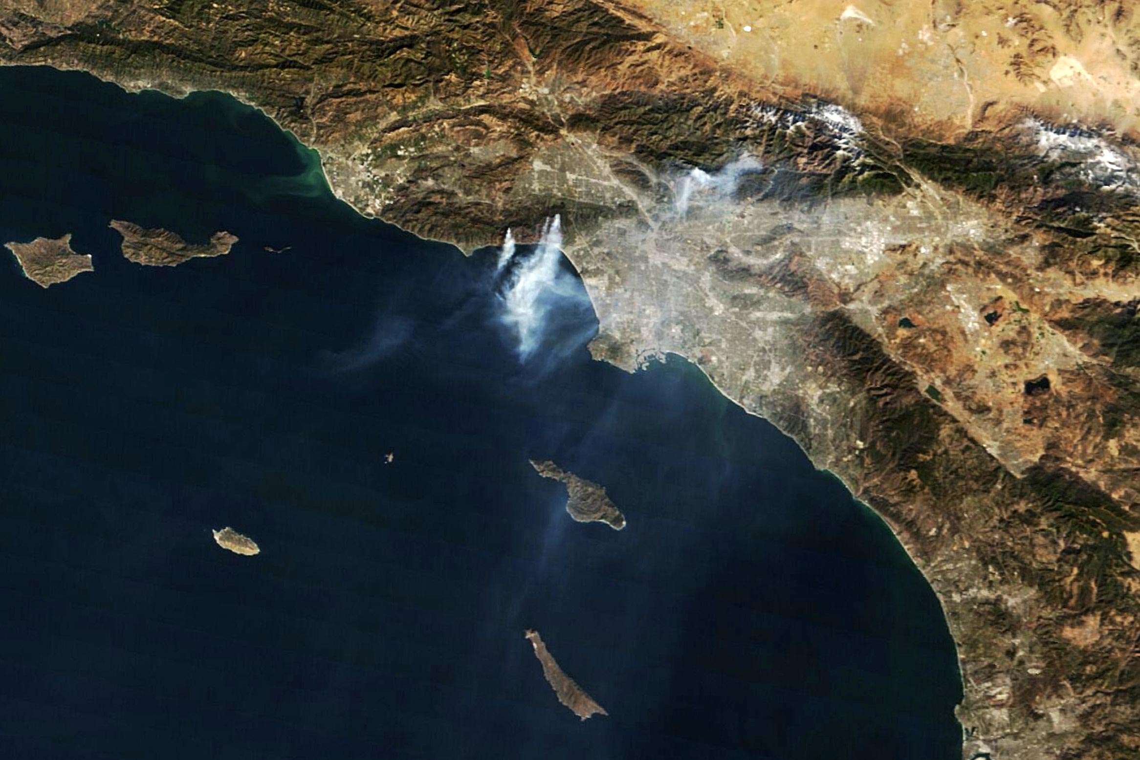
NASA’s Terra satellite, equipped with the Moderate Resolution Imaging Spectroradiometer (MODIS), captured this striking image (above) of the region around 10 a.m. local time on January 10. During this period, a red flag warning was in effect, signaling high fire danger due to weather conditions that made the ignition and spread of fires more likely.
Escalating Fire Coverage
Centered in the image, several distinct plumes streamed south over the ocean from the Palisades fire, which burned through the Pacific Palisades neighborhood and west into Malibu. The fire had spread to 20,400 acres (83 square kilometers) and was 8 percent contained by this point, according to Cal Fire. To the east, smoke billowed from the Eaton fire in and around Altadena. This fire had burned 13,700 acres (55 square kilometers) and was 3 percent contained at the time of the image.
Monitoring the Progress
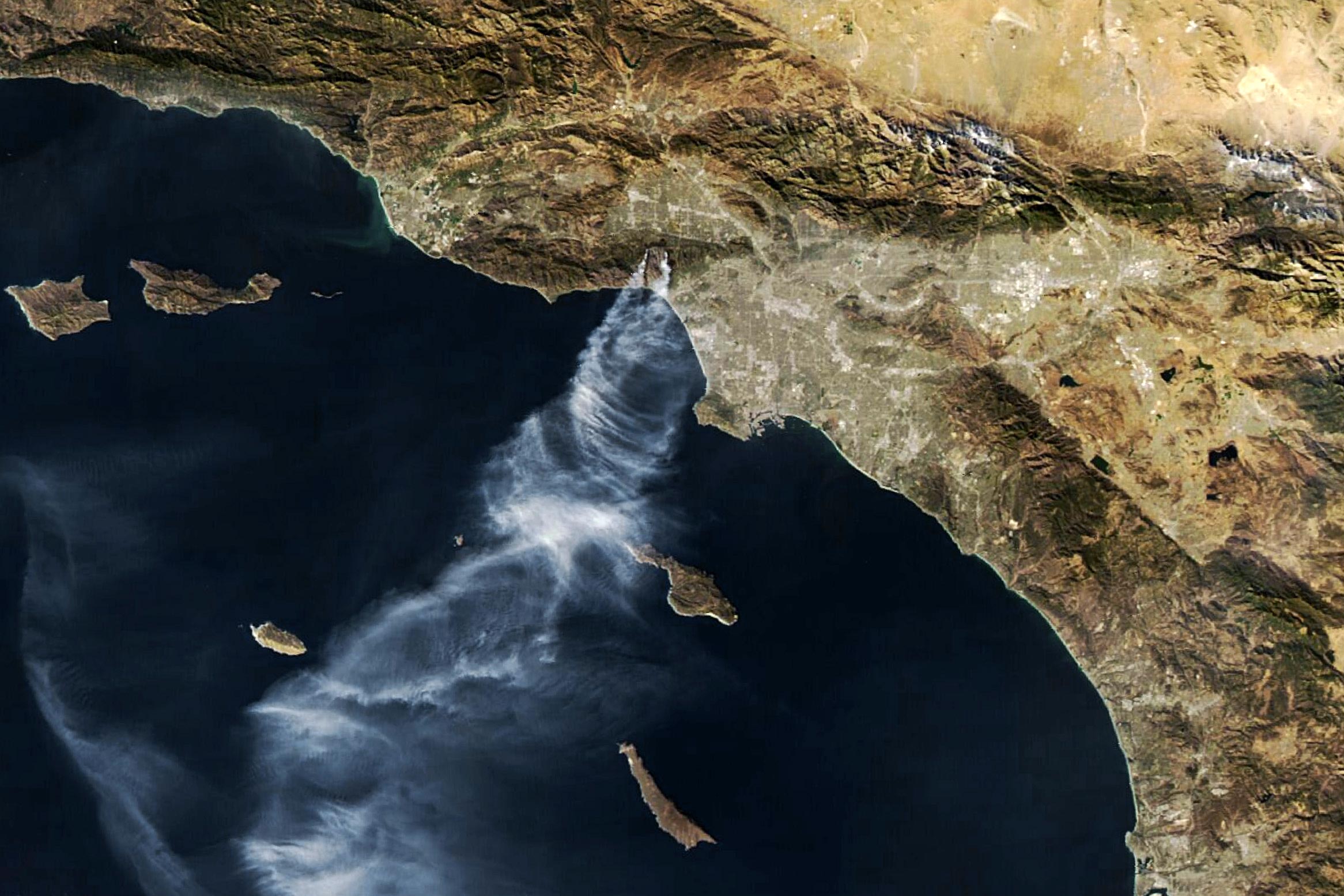
The following day, the MODIS instrument on NASA’s Aqua satellite acquired the image above around 2 p.m. local time. The orbits of the Terra and Aqua satellites are timed such that MODIS instruments observe Earth’s surface each morning and afternoon, respectively.
While both large fires remained active on the afternoon of January 11, only plumes from the Palisades fire are easy to discern in the image. The Palisades fire had grown to 22,700 acres and was 11 percent contained, while the Eaton fire expanded slightly to 14,117 acres and was 15 percent contained, reported Cal Fire.
A reprieve from the gusty wind conditions on January 11 helped firefighters make progress toward containing both blazes. However, forecasters expected strong winds and fire weather to return in subsequent days.
NASA’s Disasters Response Coordination System has been activated to support agencies responding to the fires, including the California Governor’s Office of Emergency Services. The team will be posting maps and data products on its open-access mapping portal as new information becomes available.
NASA Earth Observatory images by Wanmei Liang, using MODIS data from NASA EOSDIS LANCE and GIBS/Worldview.
Never miss a breakthrough: Join the SciTechDaily newsletter.
Follow us on Google and Google News.