
A massive 7.7 earthquake and powerful aftershock struck near Mandalay, Burma, shaking buildings and damaging infrastructure as far as Bangkok.
Satellite imagery from NASA and the European Space Agency revealed dramatic ground shifts of over 6 meters, caused by strike-slip movement along the Sagaing Fault. Scientists believe the quake may have been a rare “supershear” event—where rupture speed outpaces seismic waves—possibly explaining the widespread destruction.
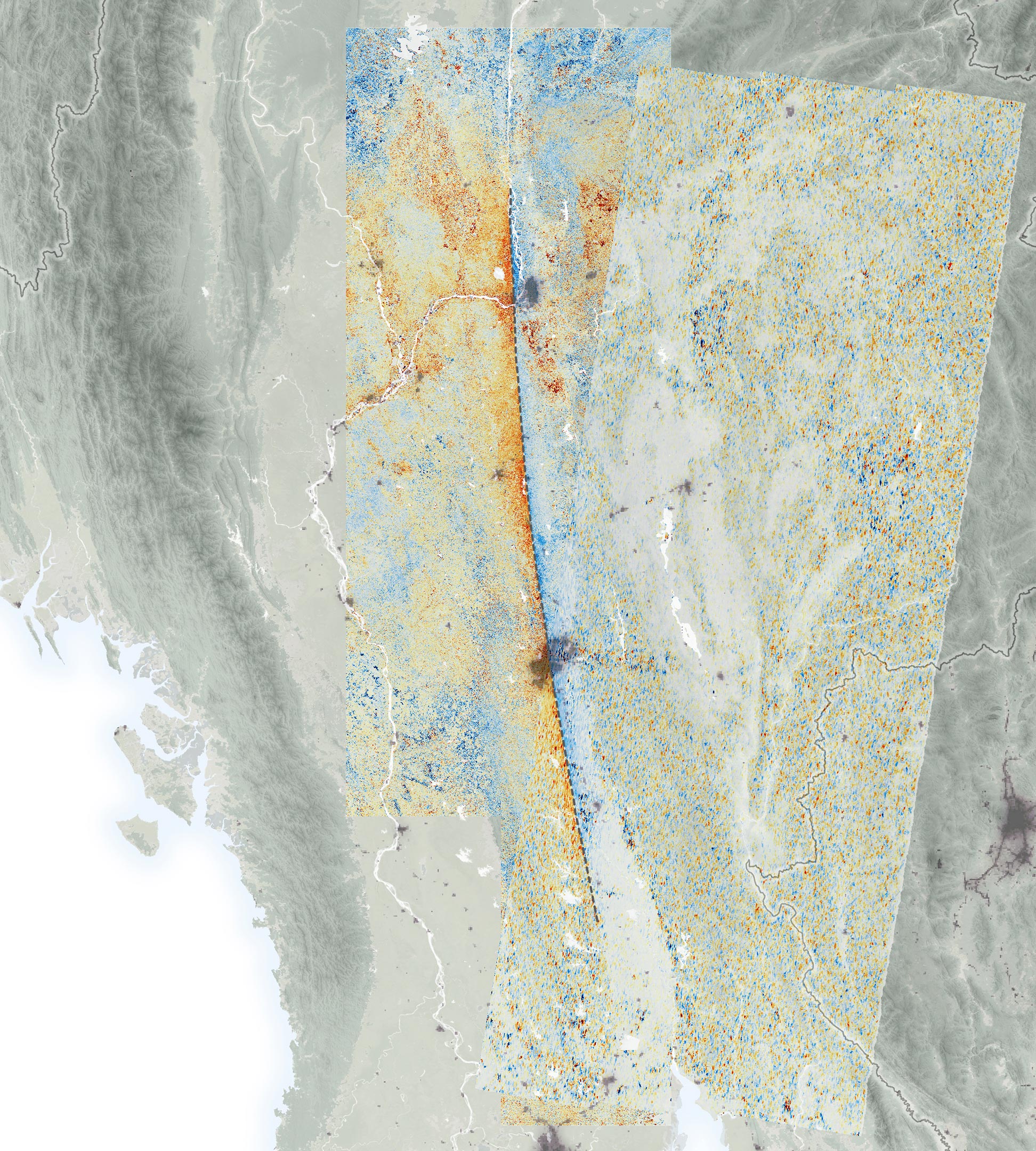
Twin Quakes Rock Central Burma
At around 12:50 p.m. local time on March 28, 2025, a powerful magnitude 7.7 earthquake struck near Mandalay, Burma (Myanmar). Just twelve minutes later, a second quake, magnitude 6.7, hit about 31 kilometers (19 miles) to the south.
Both earthquakes originated about 10 kilometers (6 miles) underground along the Sagaing Fault. The intense shaking caused widespread building damage near the epicenters, and the effects were felt as far away as Bangkok, Thailand, nearly 1,000 kilometers (600 miles) to the southeast.
Satellite Eyes on the Ground Shift
To better understand the ground movement, scientists at NASA’s Jet Propulsion Laboratory (JPL) used radar and optical satellite data. Their analysis showed dramatic shifts in the landscape, with some areas along the fault moving over 3 meters (10 feet) in opposite directions — adding up to more than 6 meters (nearly 20 feet) of total displacement in places. In the map below, red pixels indicate northward motion, while blue pixels show movement to the south.
The map is based on data from the Advanced Rapid Imaging and Analysis (ARIA) team at JPL and the California Institute of Technology’s Seismological Laboratory, a team that develops state-of-the-art deformation measurements, change detection methods, and physical models for use in hazards science and response.
Radar and Optical Imaging Reveal Fault Motion
The ARIA team drew from radar and optical data acquired by the European Space Agency’s Copernicus Sentinel-1A and Sentinel-2B/C satellites. Sentinel-1A employs synthetic aperture radar (SAR) to image the land surface using microwave pulses, while the Sentinel-2 satellites acquire optical data through an onboard multispectral sensor. Using data from the three satellites, the ARIA team computed estimates of horizontal ground motion within the earthquake rupture zone by tracking pixel offsets between pre- and post-earthquake images.
Models produced by the U.S. Geological Survey (USGS) indicated the earthquakes likely resulted from strike-slip motion along the north-south-oriented Sagaing Fault, which is at the interface between the Indian and Eurasian tectonic plates. The data in the image confirm right lateral strike-slip motion along the fault and help to constrain modeled estimates of fault rupture extent and surface displacement due to the earthquakes.
A History of Major Quakes Along the Sagaing Fault
This region has a history of significant seismicity, with six earthquakes of greater than 7.0 magnitude occurring within about 250 kilometers (150 miles) of the March 28 quakes since 1900, according to the USGS. The surface rupture generated by the March 28 earthquakes has been estimated, based in part on the data shown, to span 550 kilometers (342 miles) in length. With a rupture extending from north of Mandalay to south of Burma’s capital, Nay Pyi Taw, it is one of the longest documented strike-slip fault-induced surface ruptures on record.
Supershear Shock: A Rare and Dangerous Phenomenon
Preliminary analyses of the rupture by other scientists found that, in addition to being especially long, it was also remarkably fast, suggesting it may have been a rare “supershear” earthquake. In these events, the slip along the fault moves faster than the seismic waves it produces, which can concentrate seismic energy ahead of the rupture. The effect may exacerbate a quake’s destructive forces and might be part of the reason why the recent events caused so much damage so far from the epicenters.
NASA Earth Observatory map by Michala Garrison, using data provided by the ARIA team at NASA/JPL-Caltech. The map is based on Sentinel-1A and Sentinel-2B/C data provided by the European Space Agency and processed by ARIA team members Robert Zinke and Cole Speed (JPL). Story by Andrew Wang (JPL) and Lindsey Doermann. Science review by Grace Bato and Eric Fielding (JPL).
Never miss a breakthrough: Join the SciTechDaily newsletter.
Follow us on Google and Google News.
9 Comments
hi
plus the earths axis tilted again…3rd time in 30yrs, 2nd on in 3yrs, this has never happened in archaeological history, we’re all seeing the evidence happen. get ready to be spanked.
Galactic Magnetic field……
There is a simple solution to stop disasters. We wrote an open letter to ministries of defence and ministries of science in several countries, to geoscientists, to research governmental institutions specialized in climate change, to authorities. The fulcrum mechanism to stop disasters.
Where did you get your information?
The japan earthquake did it also then you have the three gorges damning China is actually slowing the earths . rotation the magnetic poles have shifted before it’s just a matter of time it will do it again .
Only 20 ft?? Loma Prierta quake that was rated a 6.9 , collapsed the Nimitz freeway, and a deck panel on the Bay bridge fell which did force the replacement for the cantilever section. This event was of course the big one for Nor Cal San Andreas fault ( which can only produce an 8.0 and the new span was designed to withstand an 8.5) the Pacific plate sliding over the North American plate and the Santa Cruz mountain range grew 17.5 feet. I would expect a 7.7 would do a lot more displacement than 20 ft. More like 60 plus.
“Burma?” The country’s name is Myanmar and has been since 1989. I suppose you’d refer the Vietnam as “French Indochina.” Duh!
The West Coast is capable of a 9.0 all the way to Alaska ,
That’s another problem that will cause a tsunami in 1964 there was a 9.2 of the coast .they day it will reach I height of 200 ft wall of water .