The NASA Earth Observatory is an initiative by the National Aeronautics and Space Administration (NASA) designed to provide a freely accessible online platform where the public can view new satellite imagery and scientific information about our planet. Launched in 1999, the Earth Observatory offers a wealth of data that includes images, stories, and discoveries about climate and the environment both on a global scale and localized regions. It serves as an important educational resource, helping to explain complex environmental processes through easily understandable visualizations and narratives. The content covers a broad range of topics, including changes in climate, sea level, the atmosphere, forests, and energy use, making critical scientific information accessible to educators, scientists, and the general public alike. This initiative underscores NASA’s commitment to studying Earth’s systems and promoting awareness about the challenges and changes our planet faces.
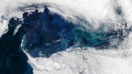
A short-lived gap in the clouds let satellites observe a stunning phytoplankton bloom east of Greenland. Satellite observations revealed a vast phytoplankton bloom off Greenland’s…
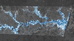
In 2024, extensive flooding in southern Brazil caused significant damage, particularly in Rio Grande do Sul. Maps showing floodwater depths were vital for disaster response…
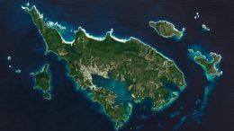
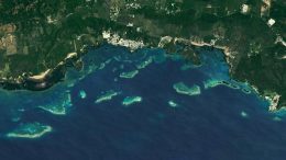
Culebra Island, located near Puerto Rico, boasts diverse marine ecosystems with extensive coral reefs protected by various reserves. Despite their ecological importance, these reefs face…
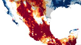
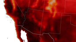
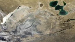
Mexico’s severe drought since 2023 has led to critical water shortages, especially in Mexico City, with drastically lowered reservoir and groundwater levels, though seasonal rains…
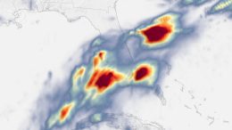
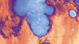
Moisture-laden tropical air brought intense downpours and flooding to the southern part of Florida, breaking multiple records on June 11 and causing widespread flooding, with…
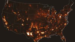
Emissions of methane, a potent greenhouse gas, may be higher than previously thought, especially from landfills. Methane, significantly more potent than CO2 as a greenhouse…
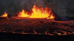
A volcanic fissure on Iceland’s Reykjanes peninsula came alive again with voluminous, vigorous flows. Iceland’s Reykjanes peninsula experienced a volcanic eruption in late May 2024,…
Strong winds and ample fuel helped spread flames over 14,000 acres of grassland in California’s San Joaquin County. In early June 2024, blazes from the…
A recent study using satellite data shows that the global coverage of greenhouses has expanded to over 13,000 square kilometers, with the largest growth occurring…
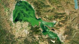
In mid-May 2024, California’s Clear Lake experienced a significant algal bloom, likely including harmful cyanobacteria, which was captured by satellite imagery. This eutrophic lake, enriched…
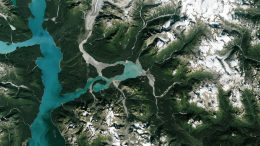
Adam’s Inlet, previously covered by thick ice, is now ice-free and features braided rivers, landslide debris, and alluvial fans spread across a dynamic landscape in…
During one of the most active U.S. tornado seasons, a powerful EF-4 tornado devastated Greenfield, Iowa, with winds of 185 mph. The destructive tornado destroyed…
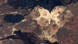
Harrat Khaybar, a major volcanic field in Saudi Arabia, showcases a diverse range of volcanoes and eruptions, reflecting millions of years of geological activity. The…
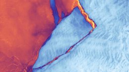
Iceberg A-83, approximately the size of Portland, Oregon, detached from Antarctica’s Brunt Ice Shelf in late May 2024, an event recorded by Landsat 9. A…