Using satellite data, geoscientists from ESA’s 3D Earth project are developing models to predict volcanic eruptions by studying deep Earth structures like mantle plumes and LLSVPs, improving our understanding of events like the Tonga eruption.
The astonishing force of the Tonga volcanic eruption shocked the world, but the fact that this underwater volcano actually erupted came as less of a surprise to geoscientists using satellite data to study changes in the temperature deep below Earth’s surface.
The cataclysmic explosion of the Hunga Tonga-Hunga Ha‘apai volcano in January is reported to have been the biggest eruption recorded anywhere on the planet in 30 years. It sent a plume of ash soaring into the sky, left the island nation of Tonga smothered in ash, sonic booms were heard as far away as Alaska and tsunami waves raced across the Pacific Ocean.
While the Tonga eruption was powerful but short, last year’s eruption of the Cumbre Vieja volcano on the Spanish Canary Island of La Palma was less explosive but lasted for almost three months.
Although different, both of these recent eruptions remind us all of how devastating nature can be. A better understanding of the natural processes that are occurring deep below our feet might bring the possibility of predicting eruptions a little closer.
ESA’s 3D Earth Project and Satellite Data for Volcano Prediction
This is one of the aims of ESA’s Science for Society 3D Earth project where an international group of geoscientists joined forces to develop a state-of-the-art global model of the lithosphere, which is a term to describe Earth’s brittle crust, the top part of the upper mantle and the sub-lithospheric upper mantle down to 400 km depth. The model combines different satellite data, such as gravity data from ESA’s GOCE, with in-situ observations, primarily seismic tomography.

In their model that shows differences in temperature, or the thermal structure, of Earth’s upper mantle, the researchers could see that these volcanoes would erupt at some point. Predicting exactly when this would happen is, however, more difficult.
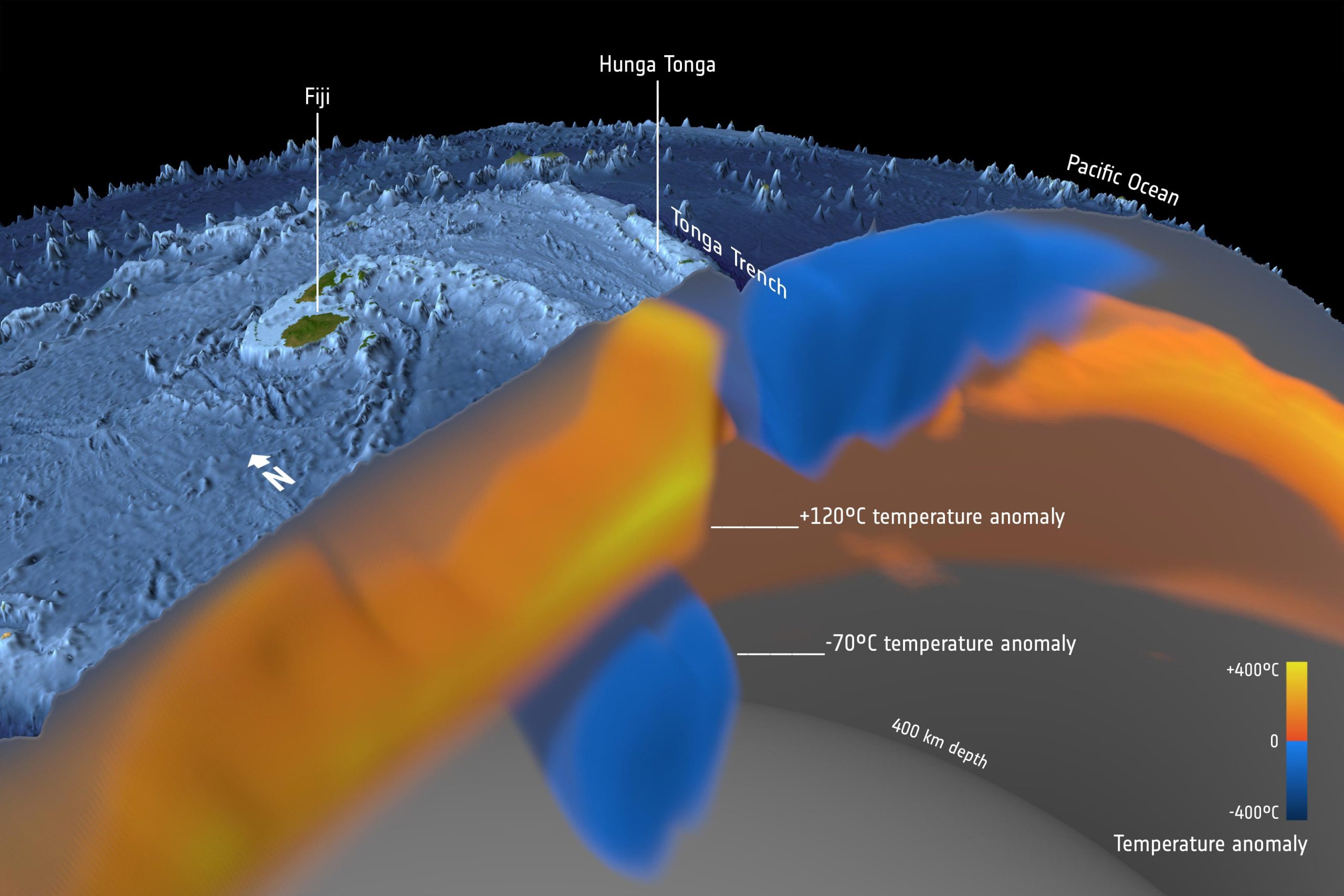
Javier Fullea, from Complutense University of Madrid, said, “Our WINTERC-G model, which uses in-situ tomographic and GOCE satellite gravity data, shows a branch of the Azores plume. It is visible from the surface down to a depth of 400 km, at the base of the upper mantle. The plume flows southeast towards Madeira and the Canary Islands surrounding the cold mantle beneath the north Atlantic’s African margin.
“Across the globe, we see that the Hunga Tonga volcano is located in a back arc basin, created by the subduction of the Tonga slab. Back arc volcanoes are associated with the cold slab being melted by the mantle as the slab slides down into the mantle.”
Seismic Tomography and Mantle Plumes Beneath the Canary Islands
Sergei Lebedev, from the University of Cambridge in the UK, adds, “From such models and seismic tomography, we see structures rising from great depth beneath the Canary Islands. These anomalies reflect hot material rising to the surface of the Earth and are referred to as hotspots or plumes and are a constant source for the volcanos at the surface.
“The origin of the Hunga Tonga-Hunga Ha‘apai volcano is different. It is a part of the Tonga–Kermadec arc, where the edge of the Pacific tectonic plate dives beneath the Australian Plate. Here, our imaging shows the layer of hydrated, partially molten rock above the plunging Pacific Plate, which feeds the volcanoes of the arc.”
But where do these thermal anomalies come from?
The answer lies even deeper, at a depth of around 2800 km, and is associated with structures at the core-mantle boundary: the Large-Low Seismic Velocity Provinces (LLSVPs). These prominent continent-sized structures appear to have a big impact on how the surface behaves.
Clint Conrad, from Norway’s Centre for Earth Evolution Dynamics, said, “There is a link between the flow in the mantle, where convection cells drive plate tectonics, and major plume locations. The flow along the core-mantle boundary pushes plume material against the LLSVPs, forming the plumes. In models, this flow is driven by downwelling slabs that surround the two LLSVPs. The Canary Islands, for example, site above the edge of the African LLSVP.”

However, the exact origin and build-up of the LLSVPs remains elusive. At the recent 4D Earth Science meeting alternative concepts and ideas were discussed using satellite data and seismological models, which will hopefully lead to more detailed studies of Earth’s interior in the near future.
Multidisciplinary Approach to Understanding Earth’s Interior
Bart Root from TU Delft, one of the organizers, summarizes, “Clearly a multidisciplinary approach is needed, where different types of satellite data are combined with seismological data in a common way to address the exact structure of Earth’s deep interior.”
ESA’s Diego Fernandez noted, “I’m happy to see that ESA’s FutureEO Science for Society project is yielding results that will further improve our understanding of the deep-lying sources of the events such as we’ve just seen in La Palma and Tonga.
“It is worth noting that data from the GOCE satellite has been key to this research. GOCE, which mapped variations in Earth’s gravity field with extreme detail and precision, completed its mission in orbit back in 2013 – and scientists still rely on the data. This is another example of the benefits our satellite missions bring well beyond their life in orbit.”
Never miss a breakthrough: Join the SciTechDaily newsletter.
Follow us on Google and Google News.
2 Comments
That’s so funny.. I’m no scientist.. but I could of told you that.. what has happened to good old fashioned common sense chaps?
I wonder how many trillions of dollars you wanted coming up with answers to questions that we already knew.. but also exactly how much damage you’ve all caused whilst doing your so called research.. stop drilling holes everywhere, it’s killing our planet.
Santorini was 1529 BC, not 1200 BC