Mount Erebus, Antarctica’s only active volcano, shows how CO2 allows volcanoes to form persistent lava lakes at the surface.
Antarctica has long been a land of mystery and heroic feats made famous by legendary explorers like James Ross, Roald Amundsen, Robert Scott, and Ernest Shackleton. A key piece of the puzzle for understanding global continental evolution, Antarctica contains examples that define the spectrum of Earth’s volcanic processes. Now, a joint University of Utah and University of Canterbury New Zealand research study shows how carbon dioxide deep underground helps magma avoid being trapped deep in the Earth and allows it to reach and pool at the surface.
The study, published today (May 30, 2022) in the journal Nature Communications “expands our understanding of the sources and transport of diverse types of magma and volatile gases to the surface,” says Phil Wannamaker, the study’s second author and a geophysicist at the University of Utah’s Energy & Geoscience Institute.
“Mount Erebus is an example of a CO2-dominated rift volcano, a complement to the more widely known arc volcanoes of the Pacific Rim and elsewhere, dominated by H2O,” adds New Zealand co-investigator Graham Hill, the study’s lead author.
“Understanding both H2O and CO2 volcanoes is important for calculating the budget of such volatile gases deep in the earth that involves injection of material into Earth’s mantle and its return to the surface to start all over again,” Wannamaker says.
Wannamaker and Hill conducted the study with University of Utah alumni John Stodt and Michal Kordy and associate scientist Virginie Maris; geophysicists Paul Bedrosian of the United States Geological Survey, Martyn Unsworth of the University of Alberta, and Yasuo Ogawa of Tokyo Institute of Technology and senior volcanologist Phil Kyle of the New Mexico Institute of Mining and Technology. Coauthors also included Erin Wallin of the University of Hawaii and mountaineer Danny Uhlmann, now studying geology at the University of Lausanne.
The study was financed by a $464,000 grant from the U.S. National Science Foundation, with comparable funding coming from the New Zealand Royal Society Marsden Fund, and in-kind support by participating colleagues.
Those Other Volcanoes
Mount Erebus is Antarctica’s only active volcano. It and its dormant companion volcano, Mount Terror, were named after the exploring ships of Sir James Ross, who discovered them and the Transantarctic Mountains in 1841. Mount Erebus was first ascended by Sir Ernest Shackleton and party in 1908.
Erebus exemplifies a family of volcanoes with an alkalic chemical composition, with lavas relatively rich in sodium, potassium and other elements including rare earths elements, while being relatively poor in silica.
Alkalic volcanoes are very different from volcanoes such as in the Cascade Range extending from northern California through British Columbia to Alaska. The Cascades are found in a place where Earth’s tectonic plates are pushing toward each other, with the crust of the ocean forced below the crust of the continent. As that ocean crust sinks into the Earth and partially melts, the water in the rocks becomes part of the melt and is the dominant “volatile,” or molecule that easily exsolves, or bubbles out of a solution like fizz out of a carbonated drink.
That evolving magma rises into and through the crust, but typically does not make it to the surface because, as the pressure from the overlying crust diminishes with ascent, the water flashes out, sometimes explosively as in the case of Mount St Helens in 1980 or Mount Lassen in 1912. The remaining magma stalls and freezes in place, typically at a depth of around three miles (five kilometers).
But Erebus volcano on Ross Island, Antarctica, is in a continental rift zone. Continental rifting happens as Earth’s crust and mantle are pulled apart. Western Utah is an example of a rift zone. It lies on the eastern boundary of the actively rifting Great Basin geological province and is being slowly stretched east-west. Erebus lies along the margin of the West Antarctic Rift System, originating tens of millions of years ago and continuing today.
The magmas in rift zone also have volatiles from the recycling of ocean crust and sediments, but these are much older and are liberated to the surface through the rift process. Instead of water, the volatiles in these magmas are CO2-dominated.
Erebus also has a persistent lava lake, a classic feature of an evolved, CO2-rich rift volcano. But lava lakes, also exemplified by Nyiragongo volcano in East Africa, and others, are not found in arc volcanoes like the Cascades and show that there must be something about rift volcanoes that allows magma to reach the surface relatively peacefully.
Picturing Magma Within the Earth
It’s impractical to collect samples of rocks from depths of more than a few kilometers beneath the surface, so researchers rely on geophysical methods to infer structures and processes at greater depths. This is similar to CT scanning of the human body. The most widely applied and familiar geophysical techniques are seismic, where sound waves are used for internal imaging. This is widely applied, for example, in exploration for oil and gas. However, natural seismic sources that can reach deep into the Earth are sparse around Erebus volcano, and images using such have only been derived to shallow depths.
Hill, Wannamaker and colleagues used a method called magnetotelluric sounding. Magnetotelluric sounding uses natural electromagnetic waves generated by the sun and by lightning bolts. Most such waves travel through the air, but “a portion penetrate the Earth, scatter off rock structures of interest and return to the surface, where we can measure them” using sophisticated “volt meters,” Wannamaker says.
As the electromagnetic waves pass through Earth’s interior, they travel faster or slower depending on the extent to which rock and other material conducts or resists electricity. Magma is conductive, so it can be detected by this technique.
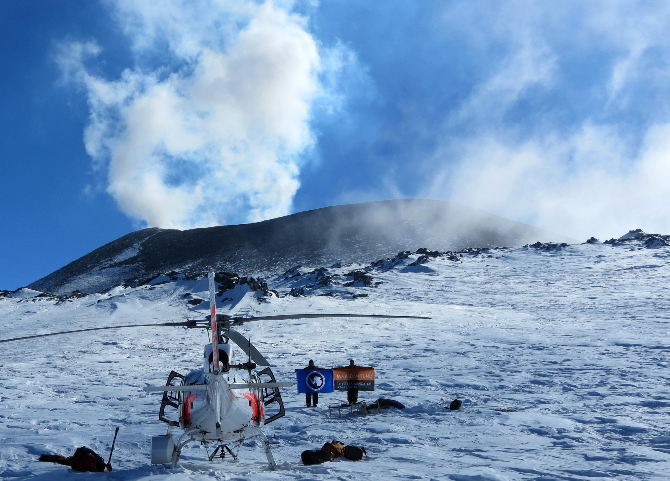
This is not the first geophysical foray into the Antarctic for Wannamaker’s group. They, with U alum and co-author Dr. John Stodt, pioneered the technique of high-fidelity magnetotelluric measurements on polar ice sheets. In addition to studies in Central West Antarctica and at the South Pole, Wannamaker led a multi-season campaign across the Central Transantarctic Mountains showing how those mountains were uplifted. Their technique now is being used by other researchers in both Arctic and Antarctic polar regions.
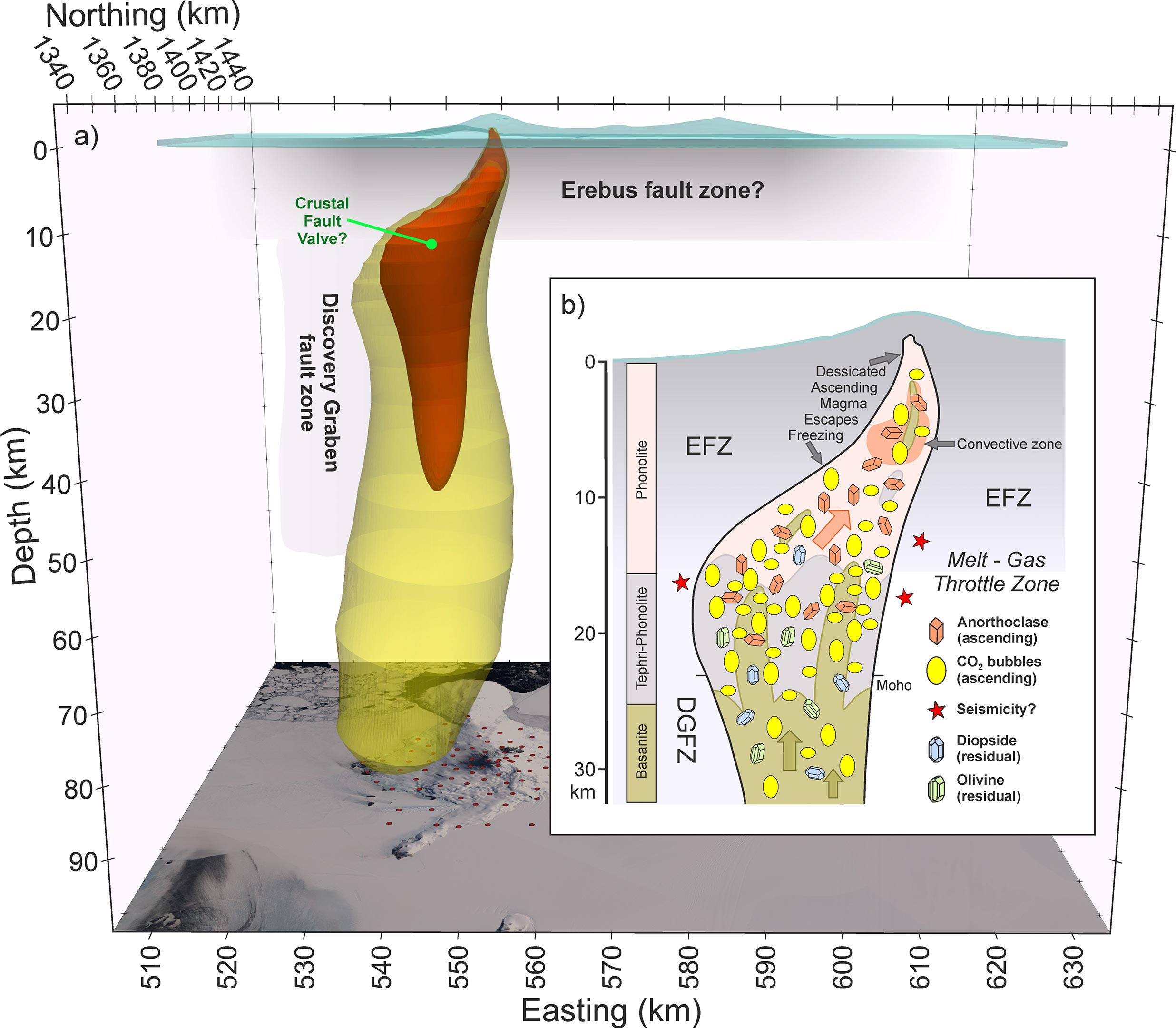
From 2014 to 2017, Wannamaker and colleagues made measurements at 129 magnetotelluric sites covering Erebus’ Ross Island. Patterns of backscattered electromagnetic radiation from all the stations then were assembled by a computer program to create an image of Earth’s crust and upper mantle through the island and volcano to a depth of about 60 miles (100 kilometers).
Their magnetotelluric data show a steep conduit of low electrical resistivity originating in the upper mantle—the magma source. But the conduit takes a pronounced lateral turn in the deep crust before reaching shallower magmatic storage and the summit lava lake. “We interpret the lateral turn to represent a structural ‘fault-valve’ controlling episodic flow of magma and CO2 gases, which replenish and heat the high-level phonolite magma evolution chamber,” Wannamaker says. Phonolite is the rock type formed by Erebus’ magma.
This magmatic valve is likely formed by intersecting north-south and east-west faults, since faults in the same east-west orientation are known to exist in the area around Erebus, and provides the magma’s path to the surface.
Unlike the H2O-rich arc volcanoes of the Cascades and the Pacific Rim, the CO2-dominated Erebus shows the structures that allow magma to rise right to the volcano’s lava lake, since the magma doesn’t stall in the crust like water-dominated magmas.
”Understanding transport controls and pathways for this type of volcano, dominated by CO2, reveals to us the scales and volumes of volatile transport in the Earth,” Wannamaker says. “Such volcanoes elsewhere are important hosts for essential mineral deposits such as rare earths, increasingly important for societies’ future resource needs.”
Reference: “Trans-crustal structural control of CO2-rich extensional magmatic systems revealed at Mount Erebus Antarctica” by G. J. Hill, P. E. Wannamaker, V. Maris, J. A. Stodt, M. Kordy, M. J. Unsworth, P. A. Bedrosian, E. L. Wallin, D. F. Uhlmann, Y. Ogawa and P. Kyle, 30 May 2022, Nature Communications.
DOI: 10.1038/s41467-022-30627-7
Funding: National Science Foundation, New Zealand Royal Society, DOE/US Department of Energy, Lumina Quaeruntur Fellowship
Never miss a breakthrough: Join the SciTechDaily newsletter.
Follow us on Google and Google News.