Sea ice in the Gulf of St. Lawrence is breaking away from its usual winter rhythms. This year, the ice was drastically below average, continuing a trend of recent winters with minimal coverage.
With temperatures running warm and winds disrupting ice formation, only sparse patches were spotted by satellite. The shrinking ice not only alters marine navigation but also affects regional weather, fishing, and wildlife like seals that depend on stable ice for breeding. As the dark waters absorb more sunlight, the Gulf could be facing longer-term changes in its ecosystem dynamics.
Unpredictable Ice in the Gulf of St. Lawrence
Each winter, sea ice spreads across the Arctic Ocean and nearby waters – seas, bays, and gulfs – reaching its maximum extent around March. But in the Gulf of St. Lawrence, off eastern Canada, this seasonal pattern doesn’t always hold. Ice formation in the gulf is more unpredictable. Some years see steady growth, while others see little to no ice at all.
On average, ice in the Gulf of St. Lawrence begins forming in December and grows more rapidly by mid-January. It typically peaks by late February and remains stable into mid-March before melting begins. However, this timeline is based on data from 1981 to 2010, and recent winters have shown a lot of variation, says Walt Meier, a sea ice expert at the National Snow and Ice Data Center (NSIDC).
Yearly Variations in Sea Ice Coverage
“Some years, it may be high early in the season and then decline,” Meier said. “Other years, it can be quite low and then shoot up as late as March.”
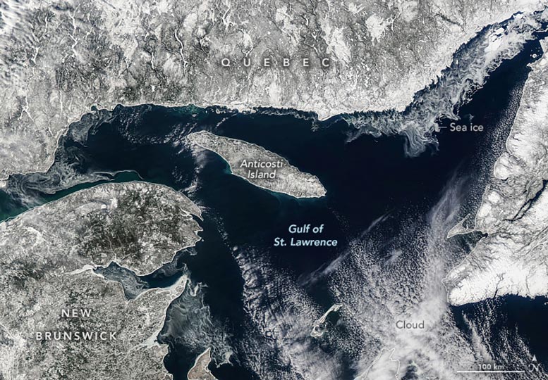
Winter 2024-2025 deviated from the typical pattern. In February 2025, the gulf’s sea ice coverage was well below average. Conditions stayed that way through mid-March, at which point sea ice was just one-third of average, according to Meier. That’s among the gulf’s lower extents observed during the satellite record, though other years have been even lower, including 2024.
NASA Satellite Captures Sparse Ice
The image above, acquired by the MODIS (Moderate Resolution Imaging Spectroradiometer) on NASA’s Aqua satellite, shows the Gulf of St. Lawrence on March 13, 2025. Patches of ice were only visible near the coastline toward the northeast and near the mouth of the St. Lawrence River to the west, and no ice warnings were in effect that day.
Air and ocean surface temperatures, which were a few degrees above normal in March, might have played a role in the low ice conditions shown in this image, according to Meier. Onshore winds can also be a factor, as they prevent the formation of new ice and push existing ice toward the shore.
Shipping Impacts and Ongoing Ice Operations
The Gulf of St. Lawrence marks the eastern end of the St. Lawrence Seaway, a shipping route that connects the Great Lakes with the Atlantic Ocean. Though the Gulf has seen low ice this winter, ice-clearing activities along the St. Lawrence River were underway around the time of this image. (Parts of the seaway system close for several months each winter.)
The Gulf of St. Lawrence, along with the Sea of Okhotsk in the Western Pacific, is one of the planet’s southernmost areas where Arctic sea ice grows. Since 2010, however, the gulf has seen four winters that were nearly ice free.
Ripple Effects on Wildlife and Climate
According to Meier, years with low ice allow the water surface, dark compared to sea ice, to absorb more of the Sun’s energy and warm up earlier than normal, with possible implications for the region’s weather and fishing. Low-ice years can also pose challenges for seals that rely on the ice for birthing their pups.
NASA Earth Observatory image by Michala Garrison, using MODIS data from NASA EOSDIS LANCE and GIBS/Worldview.
Never miss a breakthrough: Join the SciTechDaily newsletter.
Follow us on Google and Google News.
4 Comments
” As the dark waters absorb more sunlight, …”
An assertion for which the facts are not in evidence. Water experiences specular reflection (different from diffuse reflectance such as snow exhibits), which means that the reflectivity varies with the angle of incidence, and all the reflected light is confined to a narrow sheaf of rays that can only be observed by looking in the direction of the sun and at that same angle as the solar angle of incidence. That means that the water is reflecting a significant amount of light, but it can only be observed at a special viewing position. Thus, the water looks dark for all other viewing positions.
https://wattsupwiththat.com/2016/09/12/why-albedo-is-the-wrong-measure-of-reflectivity-for-modeling-climate/
“Winter 2024-2025 deviated from the typical pattern.”
Of course! We are coming off a very warm El Nino year, where the water was warmer than during a “typical” year, perhaps influenced by the Hunga Tonga–Hunga Haʻapai submarine volcano. Why was there no mention of either influence?
When there is a thick cover of ice, it serves to insulate the underlying water, preventing it from getting as cold as the air. When the water is too warm to freeze, and is in direct contact with the air, it cools more rapidly even if it doesn’t get cold enough to freeze. It is part of the many negative feedback loops that tend to damp extreme changes.
“One swallow does not a Spring make.”
The late Hans Neu, Canadian oceanographer, did a 1964 study of the structure of salinity and temperature in the estuary of the St. Lawrence River. The outgoing freshwater powers a two way flow system pulling saltwater flow into the system. This saltwater is from deep denser warmer saltwater layers and is warmer. That is why on the north side of the Gulf of St. Lawrence and estuary and the south side of the Gaspe Peninsula and the Anticosti Is. (sp?) there is some open water throughout. It typically does not freeze. This is because of flow regulation by all the dams feeding the St. Lawrence and Gulf. In short, there are higher winter flows from the dams now so there is deep warm saltwater entering the Gulf of St. Lawrence. It is a real heat polluter. Neu mentioned a ratio of 100 to 1 of salt water entering and freshwater leaving at Point De Mont. The spring pulse energy is reduced by the dams but some of that kinetic energy is transferred to the winter. Neu explained all this in 1964 and 1970 when he wrote papers about this but these government studies and his papers went unpublished. I wonder why? Now, a number of Canadian and US citizens are aware of the studies. This churned Arctic warmth (CAW )is a part of the problem of a more open GOSL and a warming Arctic that should be considered.