
Vikings likely sailed farther offshore, navigating by stories and island harbors. Jarrett’s voyages show the boats’ stability and the value of teamwork.
Archaeologist Greer Jarrett from Lund University in Sweden has spent the past three years sailing along routes once used by the Vikings. His findings show that the Vikings likely sailed much farther from Scandinavia and farther from the coast than previously believed. In his latest study, he presents evidence of a decentralized network of ports located on islands and peninsulas, which likely played a key role in Viking trade and travel.
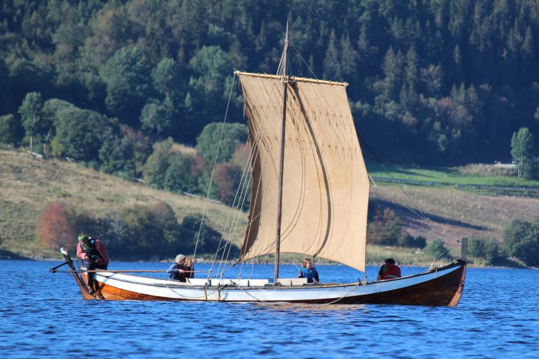
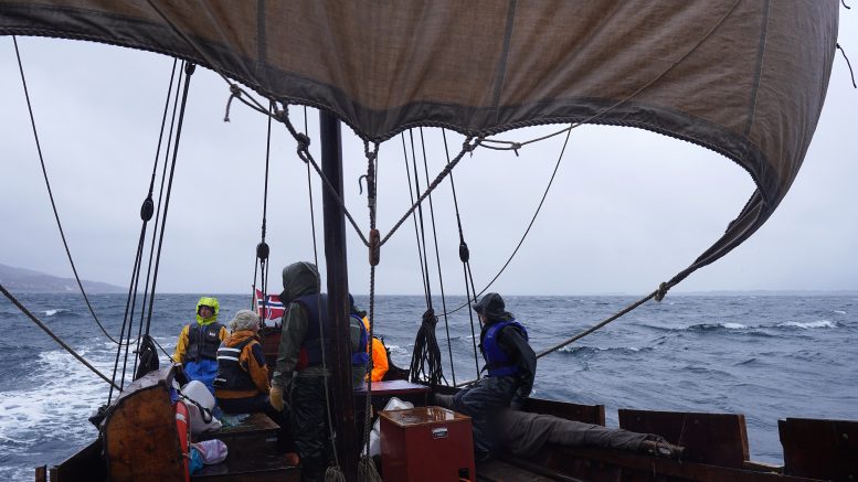
The sailing boat, an open square-rigged clinker vessel modeled after those used during the Viking Age (800 to 1050 AD), made a journey from Trondheim to the Arctic Circle and back in 2022. Since then, Jarrett and his team have sailed more than 5,000 kilometers along historic Viking trade routes. His research suggests that Viking voyages often took place well offshore, challenging earlier assumptions about their navigation methods.
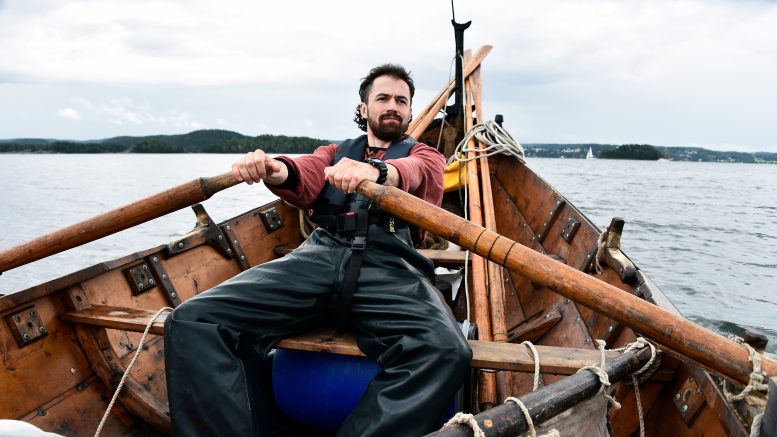
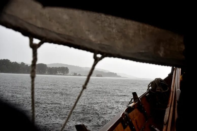
“I can show that this type of boat sails well on open water, in tough conditions. But navigating close to land and in the fjords sometimes presents challenges that are just as great, but not as obvious. Underwater currents and katabatic winds blowing down from mountain slopes, for example,” says Greer Jarrett, a doctoral student in archaeology at Lund University.
Jarrett’s research trips have involved real risks. When the yard that supported the mainsail broke off the coast of Norway, the crew had to improvise to avoid a dangerous situation.
“The cold in the Lofoten Islands was a challenge. Our hands really suffered. At that point, I realized just how crucial it is to have a good crew,” says Greer Jarrett.
Has interviewed Norwegian seafarers
Jarrett has also tested the boat on open water, sailing in both the Kattegat and the Baltic Sea. Although the boat lacks a deep-draught keel, he says it remains surprisingly stable.
In an earlier study, Jarrett and his colleagues showed that during the Middle Ages, Greenlanders could use this type of boat to reach remote areas of the Arctic in search of walrus tusks.
To trace specific Viking routes, Jarrett interviewed sailors and fishermen about traditional routes used in the 19th and early 20th centuries, when engine-free sailing boats were still widely used in Norway.
“I used the experience of my own journeys and the sailors’ traditional knowledge to reconstruct possible Viking Age sailing routes.”
Stories helped Vikings navigate
The Vikings did not navigate by map, compass, or sextant. Instead, they used “mental maps” where memories and experiences played a crucial role. They also used myths linked to various coastal landmarks.
“Examples include Viking stories about the islands Torghatten, Hestmona, and Skrova off the Norwegian coast. The stories serve to remind sailors of the dangers surrounding these places, or of their importance as navigation marks.”
These preserved myths are the last remnants of what must once have been a landscape steeped in stories. Jarrett calls this a “Maritime Cultural Mindscape”. Small islets, skerries, and reefs were all part of a web of stories that helped the Vikings navigate through the landscape, and that were passed down through generations of seafarers.
Possible Viking harbors identified
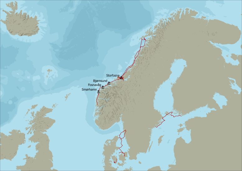
Through a combination of direct experience of the characteristics of the boats and digital reconstruction of what the landscape looked like in the Viking Age, Jarrett has identified four possible Viking harbors along the Norwegian coast in his latest publication. (See image)
The locations of these ports (Jarret calls them “havens”) are farther out to sea than the major ports and hubs known to date.
“With this type of boat, it has to be easy to get in and out of the harbor in all possible wind conditions. There must be several routes in and out. Shallow bays are not an issue because of the shallow draft of the boats. Getting far up the narrow fjords, however, is tricky. They are difficult to sail upwind with a square rig, and the boats are sensitive to katabatic winds.”
Jarrett’s hypothesis is that during the Viking Age, such small, easily accessible harbors abounded. Places where sailors could pause, rest, and meet other seafarers.
“A lot of the time, we only know about the starting and ending points of the trade that took place during the Viking Age. Major ports, such as Bergen and Trondheim in Norway, Ribe in Denmark, and Dublin in Ireland. The thing I am interested in is what happened on the journeys between these major trading centers. My hypothesis is that this decentralized network of ports, located on small islands and peninsulas, was central to making trade efficient during the Viking Age.”
Mast fixed with oars
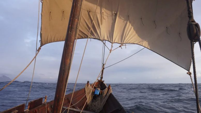
Jarrett’s research trips have faced a few challenges. On their way back from Lofoten in May 2022, the yard (mast spar) holding up the mainsail broke as they sailed through the middle of Vestfjorden. The accident happened with the vessel 25 kilometers out to sea.
“We had to lash two oars together to hold the sail, and hope that it would hold. We made it back to the harbor safely, but then we had to spend several days repairing the boat before we could sail again.”
“On another trip, a minke whale suddenly surfaced and flapped its huge tail fin just meters from the boat.”
Jarret’s adventures have also highlighted how important relationships must have been during the Viking voyages.
“You need a boat that can withstand all kinds of weather conditions. But if you don’t have a crew that can cooperate and put up with each other for long periods, these journeys would probably be impossible,” Jarrett concludes.
Reference: “From the Masthead to the Map: an Experimental and Digital Approach to Viking Age Seafaring Itineraries” by Greer Jarrett, 8 May 2025, Journal of Archaeological Method and Theory.
DOI: 10.1007/s10816-025-09708-6
Never miss a breakthrough: Join the SciTechDaily newsletter.
Follow us on Google and Google News.
2 Comments
Interesting article. Would be wonderful and greatly appreciated if the correct use of the word Viking would be respected.
To go Viking – a Scandinavian, of the Viking Age who sailed out to pillage and raid.
Viking Age – the period when we some of the Norse population sailed from Scandinavia to pillage and raid.
Norse – the culture and population of the Nordic/Scandinavian of the Viking Age.
No population was or has been ever named “Vikings”. Only those who actually went Viking were Vikings.
Respectfully and thank you, Christina
“The Vikings did not navigate by map, compass, or sextant. Instead, they used “mental maps” where memories and experiences played a crucial role.”
What of the Medieval legends of Norse sailors using ‘sunstones’ made of calcite or cordierite in lieu of a compass?