Only a tiny fraction of the deep ocean is explored, leaving 66% of Earth’s surface largely unseen. Researchers urge global, inclusive efforts to map and protect this vast and vital ecosystem.
In a groundbreaking study published in Science Advances, researchers from the Ocean Discovery League reveal that only a tiny portion of the deep seafloor has ever been imaged. Although the deep ocean covers 66% of Earth’s surface, it remains mostly unexplored.
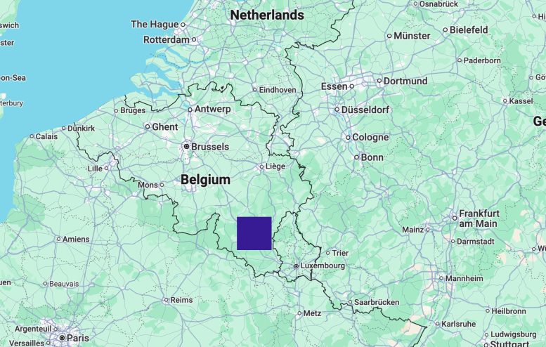
The study is the first to show that over decades of deep-sea exploration, humans have visually observed less than 0.001% of the deep seafloor—an area comparable to the size of Rhode Island or about one-tenth the size of Belgium.
The deep ocean, defined as regions deeper than 200 meters, supports a wide range of ecosystems and provides essential services such as oxygen production, climate regulation, and potential pharmaceutical discoveries. It plays a critical role in maintaining Earth’s environmental balance. Despite this, scientific research into the deep ocean remains extremely limited. Most visual surveys have been concentrated in a small number of regions and countries. Visual imaging is a key tool for studying the deep seafloor and represents one of the three main pillars of ocean exploration, alongside mapping and sampling.
Urgency for deeper understanding
“As we face accelerated threats to the deep ocean—from climate change to potential mining and resource exploitation—this limited exploration of such a vast region becomes a critical problem for both science and policy,” said Dr. Katy Croff Bell, President of Ocean Discovery League, National Geographic Explorer, and lead author of the study. “We need a much better understanding of the deep ocean’s ecosystems and processes to make informed decisions about resource management and conservation.”
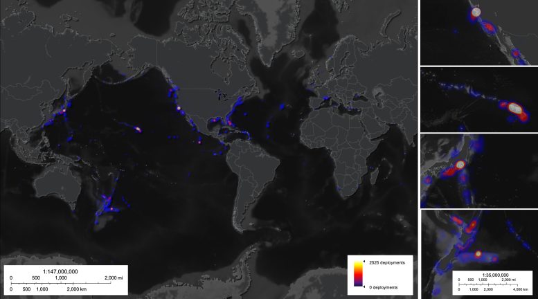
Using data from approximately 44,000 deep-sea dives with observations conducted since 1958, across the waters of 120 different countries, the study is the most comprehensive global estimate of deep-sea benthic observations to date and highlights the disparity in global exploration efforts.
Given that not all dive records are public, the researchers assert that even if these estimates are off by a full order of magnitude, less than one-hundredth of 1% of the seafloor would have any visual records. In addition, almost 30% of documented visual observations were conducted before 1980 and often resulted in only black and white, low-resolution, still imagery.
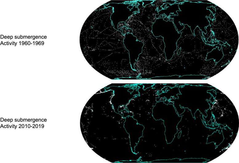
Remarkably, over 65% of visual observations have occurred within 200 nautical miles of just three countries: the United States, Japan, and New Zealand. Due to the high cost of ocean exploration, a mere handful of nations dominate deep-sea exploration, with five countries— the United States, Japan, New Zealand, France, and Germany—responsible for 97% of all deep-sea submergence observations.
This bias in geographic coverage and operator representation has led the oceanographic community to base much of its characterization of the deep ocean ecosystem on this incredibly small and unrepresentative sample.
Huge gaps in habitat coverage
The study also highlights the knowledge gap regarding seafloor habitats. Certain geomorphological features, such as canyons and ridges, have been the focus of significant research, while vast areas, including abyssal plains and seamounts, remain underexplored.
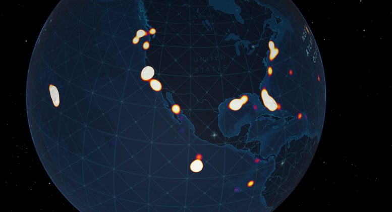
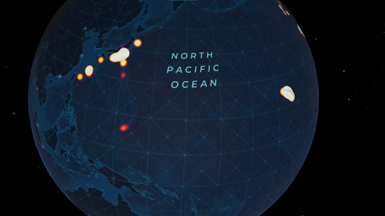
This heatmap animation shows the concentration of known deep-sea dives with visual observations in the North Atlantic. Credit: Ocean Discovery League
These findings underscore the urgent need for a more comprehensive and global effort to explore the deep ocean, ensuring that scientific research and conservation efforts accurately reflect the true extent of the seafloor. As noted in the study, if the scientific community were to make all assumptions about terrestrial ecosystems from observations of only 0.001% of that total area, they would be basing their assessments of all land-based life on Earth on an area roughly the size of Houston, Texas.
To address these challenges, the researchers call for expanding exploration efforts and utilizing emerging technologies to increase access to the deep ocean. With advancements in smaller, more affordable deep-sea tools, there is an opportunity to broaden the scientific community’s reach, including low- and middle-income nations in ocean exploration and research.
Local communities and new tools offer hope
“There is so much of our ocean that remains a mystery,” says Dr. Ian Miller, Chief Science and Innovation Officer at the National Geographic Society, which contributed funding for this work. “Deep-sea exploration led by scientists and local communities is crucial to better understanding the planet’s largest ecosystem. Dr. Bell’s goals to equip global coastal communities with cutting-edge research and technology will ensure a more representative analysis of the deep sea. If we have a better understanding of our ocean, we are better able to conserve and protect it.”

This study represents a crucial step in understanding the gaps in ocean exploration and the need for comprehensive global strategies to ensure the protection and sustainable management of the deep ocean. The authors hope these findings will encourage more scientific collaboration, leading to a deeper understanding of our planet’s most vital ecosystem.
Reference: “How little we’ve seen: A visual coverage estimate of the deep seafloor” by Katherine L. C. Bell, Kristen N. Johannes, Brian R. C. Kennedy and Susan E. Poulton, 7 May 2025, Science Advances.
DOI: 10.1126/sciadv.adp8602
Funding for this study was provided in part by the National Geographic Society and Rolex Perpetual Planet Expeditions program and the Cabot Family Charitable Trust.
Never miss a breakthrough: Join the SciTechDaily newsletter.
Follow us on Google and Google News.
2 Comments
“…, if the scientific community were to make all assumptions about terrestrial ecosystems from observations of only 0.001% of that total area, they would be basing their assessments of all land-based life on Earth on an area roughly the size of Houston, Texas.”
And yet, most climatologists are apparently convinced that the ocean plays little to no role in the warming of the atmosphere, despite knowing that Black Smoker hydrothermal fields, submarine volcanoes, and spreading-center flood basalts exist. The new NASA SWOT satellite has more than doubled the known seamounts, suggesting they may play a more significant role than previously thought:
https://scitechdaily.com/nasas-swot-satellite-just-revealed-thousands-of-hidden-mountains-beneath-the-ocean/
This article is being published partially to negate the ocean maps provided by Google and many other maps provided even earlier because larger scale maps reveal an ocean floor with features that appear less than natural. These features unfortunately raise many concerning questions because “less than natural” defies the principle of randomness while suggesting that such features are derived from purpose and function, traits of intelligence and meaningful thought. Heavens to Betsy, we can’t have that because that would mean the godless Yale University chaos freaks who desire to rule the world and proclaim themselves as God may be challenged, even thwarted in their relentless, abusive exploitation of humans and Neo Sapiens who are better than them. Angel-Demon 69