Rapid meltwater pressure changes under Greenland’s ice, not water volume, drive glacier speed, revealing new insights for predicting sea level rise.
With data from a 2016 expedition, scientists supported by NASA are shedding more light into the complex processes under the Greenland Ice Sheet that control how fast its glaciers slide toward the ocean and contribute to sea level rise.
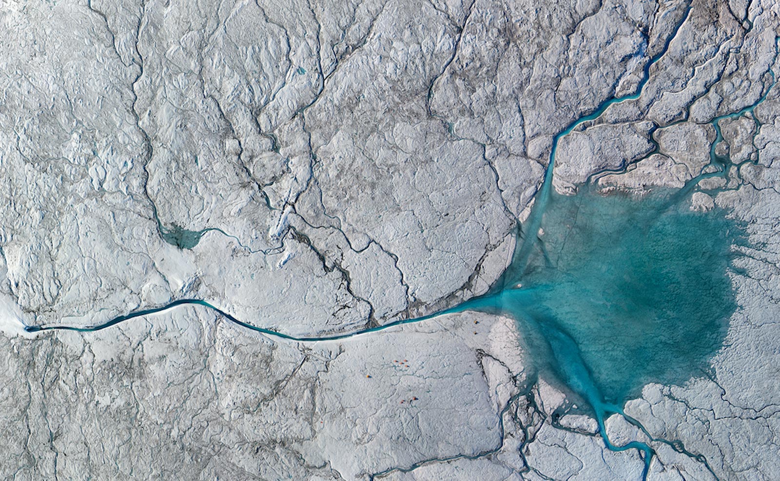
On the surface of the ice sheet, bottomless sinkholes called moulins can funnel meltwater into the base of the ice. As that water reaches the ice sheet’s underlying bed, it can make the ice detach slightly and flow more rapidly.
Glaciers that slide faster can eventually lead to the ice sheet melting a bit faster than expected, also increasing the amount of ice calved into the ocean. With a vast surface area roughly the size of Mexico, Greenland’s melting ice is the largest contributor to global sea level rise.
In a new study, published on April 5, 2021, in Geophysical Research Letters, the authors concluded that the one important factor influencing the speed of a sliding glacier in southwest Greenland was how quickly water pressure changed within cavities at the base of the ice where meltwater met bedrock.
“Even if the cavities are small, as long as the pressure is ramping up very fast, they will make the ice slide faster,” said Dr. Laurence C. Smith, a professor of environmental studies and Earth, environmental, and planetary sciences at Brown University in Providence, Rhode Island.
It’s the first time observations directly from field research show how changes in the volume of water under the Greenland Ice Sheet drive the flow velocities of a glacier.
Challenging the Steady-State Model of Ice Flow
The findings contradict a long-held view about ice sliding velocities and water stored under a glacier known as steady-state basal sliding law, which has helped scientists predict how fast ice sheets will slide based on the total volume of water underneath the ice.
Five years after a NASA-funded field study returned to to set up camp once again in the melt zone of the Greenland Ice Sheet, a new study adds to the rich findings from this innovative project. We look back on this bold undertaking, which featured helicopters, floating drifters plunging into holes in the ice, and all-night shifts operating a sonic boogie board under endless daylight. Scientist Larry Smith, at the time with UCLA and now with Brown University, takes us back to the challenges on the ice and the important findings made with the hard-won data. Credit: NASA’s Goddard Space Flight Center/Scientific Visualization Studio; Additional field footage courtesy UCLA
Dr. Lauren Andrews, a glaciologist at NASA’s Goddard Space Flight Center in Greenbelt, Maryland, likes to explain the interactions between surface meltwater, basal ice, and the bedrock, as tires that slide very rapidly on a wet road because of hydroplaning.
“If you have a rapid perturbation of water going into the subglacial system, you overwhelm the system, and so you create essentially a layer of water at the interface that’s not contained in channels or cavities anymore,” Andrews said.
It’s not the actual volume in water that drives ice velocity, she explained, but the speed with which it builds up at a bedrock ice interface. For slow increases in water the subglacial system has time to evolve to accommodate the same amount of water.
Until recently, the lack of data directly from the ground had made it difficult for scientists to probe the interactions that speed up glaciers in Greenland. One of the trickiest aspects preventing scientists from fully understanding ice sliding dynamics is the need to pair measurements of the flow of meltwater into a glacier with observations of the motion of the ice at the surface.
The research team set camp on Russell Glacier near Kangerlussuaq, Greenland, and studied a glacial river named to honor the late NASA researcher Alberto Behar. By comparing GPS measurements of the motion of ice at the surface with the amount of meltwater discharging into a vertical shaft in the glacier, known as a moulin, as well as meltwater exiting the glacier’s edge, the team identified changes in water stored under the ice that corresponded with small accelerations in the ice at the surface. Past research on small alpine glaciers guided the design of the study.
“There’s not a direct one-to-one relationship between the melting on the top and the meltwater exiting the ice sheet because the water is going through goodness knows what down below,” Smith said.
Implications for Satellite Missions and Climate Models
The new findings will be valuable for satellites such as the upcoming NISAR satellite mission, a joint Earth-observing mission between NASA and the Indian Space Research Organization (ISRO), which will measure changes in ice surface velocity with unprecedented resolution for the entire Greenland and Antarctic ice sheets, said Thorsten Markus, Cryospheric Science program manager at NASA. Projected to launch no earlier than 2022, NISAR may also enable further studies of ice surface velocities at much larger scales.
Eventually, combining satellite observations with data acquired from the ground can help scientists as they consider adjusting their models to represent the hydrology at the base of ice sheets more accurately.
Integrating new data in models is a gradual process, but Smith hopes the new findings can improve how climate models predict the pace of future sea level rise from Greenland’s ice in the face of climate change.
“The only tools that we have to predict the future are models,” Smith said. “We have remote sensing, and we have field campaigns, so if we can use both to improve our modeling capability, we’ll be better able to adapt and mitigate sea level rise and climate change.”
Reference: “Supraglacial River Forcing of Subglacial Water Storage and Diurnal Ice Sheet Motion” by L. C. Smith, L. C. Andrews, L. H Pitcher, B. T. Overstreet, Å. K. Rennermalm, M. G. Cooper, S. W. Cooley, J. C. Ryan, C. Miège, C. Kershner and C. E. Simpson, 5 April 2021, Geophysical Research Letters.
DOI: 10.1029/2020GL091418
The fieldwork is one of many projects NASA has supported over the last two decades to interpret satellite observations and study the Greenland Ice Sheet using local field data.
Never miss a breakthrough: Join the SciTechDaily newsletter.
Follow us on Google and Google News.
2 Comments
“… bottomless sinkholes called moulins CAN funnel meltwater into the base of the ice.”
For staters, something can’t truly be “bottomless” if it terminates at the base of the ice! That is a pretty careless description for a science article. It is more like what I would expect from a carnival barker trying to convince rubes to part with their money to see something described with undefined superlatives.
I’ve tried to find evidence of the measured depth of moulins. However, the best I have come up with is uncited claims of a few hundred meters to 1/2 mile (~800m). It is conceivable that such depths might be achieved, if the water were warm enough to melt the ice under it. However, at depths greater than about 50 meters, there is a constraint on the propagation and longevity because the ice transitions to plastic flow and tends to seal transverse tensional crevasses.
Therefore, while I’ll accept that under the right conditions, surface melt water MIGHT reach bedrock at the thinner margins, I don’t think that there is enough evidence to claim a general condition.
Furthermore, when I was in the army, I supervised an ice-tunnel closure-survey at Camp Tuto (between Thule Air Base, and Camp Century). There was disconcerting evidence of a large volume of water flowing above the tunnel (We could hear it!) but the tunnel itself was dry. The tunnel was not on bedrock, so it is possible that water was flowing at different levels. Even so, The tunnel was at the terminus of the ice sheet where it was only a few hundred feet thick.
https://en.wikipedia.org/wiki/Moulin_(geomorphology)
CARBON HAS 30-50 YEAR LAG TIME BEFORE MOLECULE
REACHES ITS FULL POTENTIAL IN HOLDING HEAT MASS
METHANE NATURAL GAS HAS 10 YEAR LAG TIME AND IS
130 TIMES HOTTER THAN A CARBON MOLECULE
WE ARE LOCKED IN TO RECORD HEAT RAIN WIND SNOW
UNTIL GREENLAND COLLAPSES
THEN JUST RECORD HEAT AND RECORD RAIN
SINCE 2005 METHANE NATURAL GAS HAS BEEN SEEPING SPEWING VENTING FROM PERMA-FROST METHANE HYDRATES MANTLE METHANE FROM ISOSTATIC REBOUNDING AND PINGOES GLOBAL WARMING FEEDBACK LOOPS
COMING OFF OF GREENLANDS 20 FEET OF SEA LEVEL RISE METHANE NATURAL GAS INDUCED WINDS CAN BRING RECORD HEAT RAIN OR SNOW ANY WHERE
METHANE NATURAL GAS
NITROUS OXIDE
WATER VAPOUR
CARBON
=
8C. TEMP RISE SINCE 1700s
RECORD HEAT RAIN WIND SNOW
EACH & EVERY YEAR
6/21/20 SIBERIAN ARCTIC 100F.
3/27/21 Gallinas 111F.
San Luis Potosi State with 44.1C. ETATW
220 FEET SLR END OF 2023 ?
https://www.youtube.com/watch?v=v9GRkZMTqCs