
California’s Channel Islands, often called North America’s Galapagos, are home to a stunning array of unique wildlife and landscapes.
From San Miguel’s windswept pinniped rookeries to Santa Cruz’s colossal sea cave and diverse endemic species, these five protected islands each hold their own secrets. Satellite imagery reveals just how varied and ecologically rich they are, and visitors willing to venture across the Santa Barbara Channel are rewarded with a rare experience of nature’s untouched beauty and ongoing restoration efforts.
A Biodiversity Hotspot in California’s Backyard
Just off the coast of Southern California lies the Channel Islands, often called “the Galápagos of North America.” Like the famous islands off Ecuador, this small archipelago supports an impressive variety of plant and animal life in a compact area. Many of these species, such as the island fox, are found nowhere else on Earth.
Of the eight Channel Islands, five belong to Channel Islands National Park. Four of these islands — San Miguel, Santa Rosa, Santa Cruz, and Anacapa — stretch across about 60 miles (100 kilometers) in the Santa Barbara Channel. The fifth, Santa Barbara Island, is the smallest and sits farther southeast.
On March 18, 2025, the NOAA-20 satellite’s VIIRS (Visible Infrared Imaging Radiometer Suite) captured a clear view of the park’s five islands from space, as seen above.
Close Yet Unique: Diverse Island Features
Although the northern islands are relatively close to each other, each has its own distinct landscape and ecology. These differences are highlighted in additional satellite images taken the same day by the Landsat 8 satellite using its OLI (Operational Land Imager).
Windswept Wilderness of San Miguel
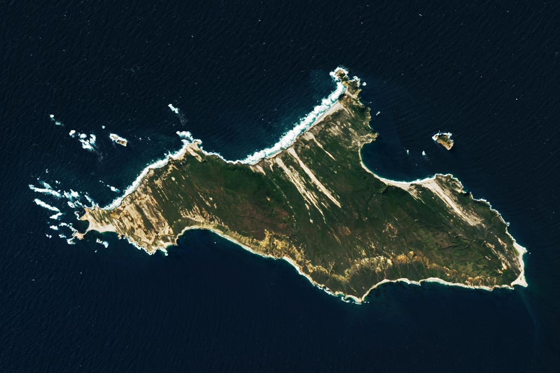
San Miguel Island is the farthest from Ventura, a popular launching spot for trips to the islands and the location of one of the park’s visitor centers. (There is another visitor center on the mainland in Santa Barbara.) The 70-mile (113-kilometer) trip, however, might be worth the effort for some intrepid visitors. Point Bennett on the island’s westernmost side displays a windswept landscape of sand and vegetation. Its beaches are the site of one of the largest rookeries for pinnipeds — mammals such as seals, sea lions, and walruses — on the western coast of North America.

Santa Rosa’s Vanishing Cloud Forests
The next island to the east, Santa Rosa, lies 40 miles from Ventura. Cloud forests — groves of tall oaks and pines that harvest water from the area’s heavy fog — were once common on the island. Though fragments remain, such as on the slopes of Black Mountain, most of these forests were decimated by grazing in the 19th and 20th centuries. The national park, U.S. Geological Survey, and partners have been making efforts to restore native vegetation and help the forests begin to recover.

Santa Cruz: Giant of Biodiversity and Caves
East of Santa Rosa lies Santa Cruz Island, just 20 miles from Ventura. This island is the park’s largest, spanning 96 square miles, and includes Diablo Peak, the park’s tallest mountain (2,450 feet/750 meters). With all this land area—three times the size of Manhattan—there’s ample space for unique plants and animals. More than 60 species are only found here, the largest number of endemic species of any of the Channel Islands. A major draw to this island, however, lies along its perimeter. At the western end of the island’s north side, visitors will find the entrance to Painted Cave, one of the planet’s largest-known sea caves.
Anacapa: Smallest Distance, Big Adventure
Anacapa Island is the closest to the California mainland and just 14 miles (23 kilometers) from Ventura. Still, as with travel to any of the islands, getting there takes some extra planning; visitors can only access the islands via boat. Park concessionaire boats offer transportation to several of the islands year-round and others on a seasonal basis. Once there, visitors usually tour the islands on foot or by kayak.
NASA Earth Observatory images by Lauren Dauphin, using MODIS data from NASA EOSDIS LANCE and GIBS/Worldview and Landsat data from the U.S. Geological Survey.
Never miss a breakthrough: Join the SciTechDaily newsletter.
Follow us on Google and Google News.