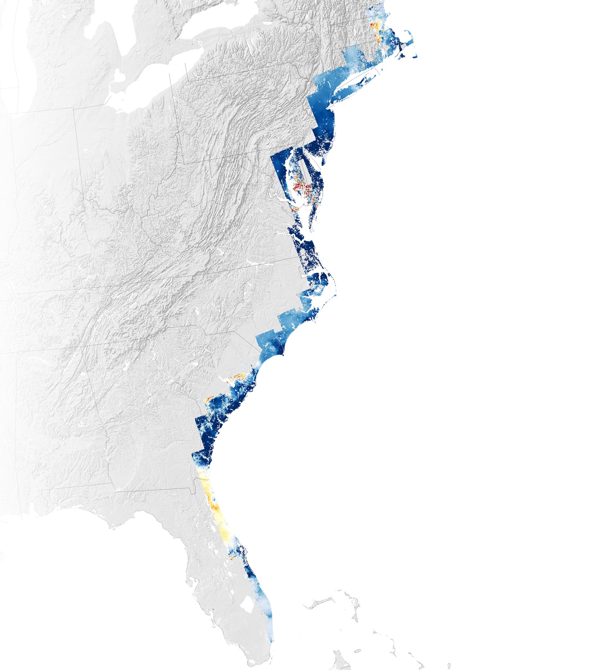
2007 – 2020
Critical infrastructure is threatened as sinking land amplifies global sea level rise.
In many parts of the U.S. East Coast, rising seas driven by melting ice and the thermal expansion of warming water is only part of what threatens coastal areas. The land is also sinking. This geologic two-step is happening rapidly enough to threaten infrastructure, farmland, and wetlands that tens of millions of people along the coast rely upon, according to a NASA-funded team of scientists at Virginia Tech’s Earth Observation and Innovation (EOI) Lab.
Infrastructure at Risk
The researchers analyzed satellite data and ground-based GPS sensors to map the vertical and horizontal motion of coastal land from New England to Florida. In a study published in PNAS Nexus, the team reported that more than half of infrastructure in major cities such as New York, Baltimore, and Norfolk is built on land that sank, or subsided, by 1 to 2 millimeters per year between 2007 and 2020. Land in several counties in Delaware, Maryland, South Carolina, and Georgia sank at double or triple that rate. At least 867,000 properties and critical infrastructure including several highways, railways, airports, dams, and levees were all subsiding, the researchers found.
The findings follow a previous study from the EOI Lab, published in Nature Communications, that used the same data to show that most East Coast marshes and wetlands—critical for protecting many cities from storm surge during hurricanes—were sinking by rates exceeding 3 millimeters per year. They found that at least 8 percent of coastal forests had been displaced due to subsidence and saltwater intrusion, leading to a proliferation of “ghost forests.”
The Underlying Causes
“Subsidence is a pernicious, highly localized, and often overlooked problem in comparison to global sea level rise, but it’s a major factor that explains why water levels are rising in many parts of the eastern U.S.,” said Leonard Ohenhen, a geophysicist at Virginia Tech. The consequences for people living along the coast include more “clear sky” tidal flooding, more damaged homes and infrastructure, and more problems with saltwater intruding into farmland and fresh water supplies.
“The good news is that subsidence is a problem that we can slow at local scales to some degree,” said Manoochehr Shirzaei, a co-author on both studies and director of the EOI Lab. Some important human-caused drivers that contribute to subsidence include groundwater extraction, the construction of dams and other infrastructure that block the natural flow of sediment that replenishes river deltas, and the drying and compaction of peat soils.
Technological Advancements in Mapping
The map above highlights the variability in the rising and falling of land—or vertical land motion—across much of the East Coast. Areas shown in blue subsided between 2007 and 2020, with darker blue areas sinking the fastest. The areas shown in dark red rose the fastest. The satellite data in the map have an average spatial resolution of 50 meters per pixel, which is better than previous maps based only on ground-based sensors.
The map was created by comparing thousands of scenes of synthetic aperture radar (SAR) data collected between 2007 and 2020 by Japan’s Advanced Land Observing Satellite (ALOS) and Europe’s Sentinel-1 satellites. Ohenhen and colleagues looked for subtle changes in the data collected at different time periods to calculate the rate of land motion using a processing technique known as interferometric synthetic aperture radar (InSAR). To check and improve the accuracy of the satellite observations, they also used horizontal and vertical velocity data from ground-based receiving stations in the Global Navigation Satellite System (GNSS).
Geological and Human Influences
Part of the reason that the Mid-Atlantic is sinking more rapidly than the northeastern U.S. is because the edge of the massive Laurentide ice sheet, which covered much of northern North America during the height of the most recent Ice Age, ran through northern Pennsylvania and New Jersey. Ice-free lands to the south of that line, especially in the Mid-Atlantic, bulged upward while ice-covered lands to north were pushed downward by the weight of the ice, Shirzaei explained. When the ice sheet started retreating 12,000 years ago, the Mid-Atlantic region began sinking gradually downward—and continues to do so today—while the northeastern U.S. and Canada began rising as part of a rebalancing process called glacial isostatic adjustment.
While the edge of the Laurentide ice sheet never got close to northern Florida, that region has relatively high rates of uplift due to another geologic process—the gradual dissolution and lightening of karst landscapes due to the infiltration of groundwater.
These natural isostatic adjustments take place relatively deep underground, occur over long periods of time, affect broad areas, and are responsible for about half of the vertical land motion that satellites observed along the East Coast, Shirzaei said. However, shorter-lived, human-caused processes happening closer to the surface can also have a strong influence in certain areas.
The rapid subsidence in some parts of the Eastern Shore in Maryland and parts of Virginia near areas of uplift is likely partly a product of groundwater withdrawals and intentional pumping of water back into aquifers to minimize the effects of saltwater intrusion, explained Ohenhen. Likewise, the high rates of subsidence in coastal Georgia, South Carolina, and North Carolina are likely influenced by the presence of dams that block sediment that would otherwise travel down several key rivers and replenish coastal lands, and the draining and compaction of peat soils.
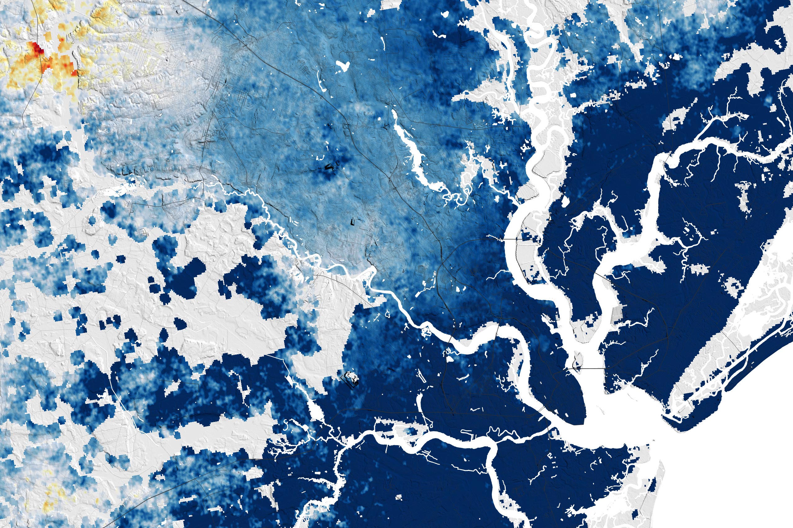
2007 – 2020
Charleston, South Carolina, is among the cities scrambling to react to subsidence and rising seas. This city of 800,000 people is one of the fastest sinking cities (about 4 millimeters per year) in the eastern U.S., with a portion of that thought to be the result of human activities, including groundwater pumping. With much of the downtown built at an elevation less than 3 meters (10 feet) above sea level, the frequency of tidal flooding has increased sharply in recent decades, and the city is considering building an 8-mile seawall around the Charleston peninsula to protect its downtown from storm surges.
The Virginia Tech team also observed that parts of Charleston had differences in the rate of subsidence within a relatively small area, a phenomenon known as differential subsidence. “That’s a problem because it puts more strain on infrastructure,” said Ohenhen. Other areas with high rates of differential subsidence were in the Eastern Shore of Maryland and Boston.
Looking Ahead
This effort to map the Atlantic Coast followed a similar effort by the same lab to map vertical land motion along the California coast. “Subsidence on the Atlantic Coast is actually worse than on the Pacific Coast,” Shirzaei said. “It is more widespread, more rapid, and more impactful because communities and infrastructure are located closer to sea level than on the West Coast.”
The lab’s next project is to map the Gulf Coast. “Our long-range goal is to map all of the world’s coastlines using this technique,” Shirzaei added. “We know that planners in several U.S. cities are already using our data to make our coastlines more resilient, and we want cities all over the world to be able to do be able to do the same.”
References:
“Slowly but surely: Exposure of communities and infrastructure to subsidence on the US east coast” by Leonard O Ohenhen, Manoochehr Shirzaei and Patrick L Barnard, 02 January 2024, PNAS Nexus.
DOI: 10.1093/pnasnexus/pgad426
“Hidden vulnerability of US Atlantic coast to sea-level rise due to vertical land motion” by Leonard O. Ohenhen, Manoochehr Shirzaei, Chandrakanta Ojha and Matthew L. Kirwan, 11 April 2023, Nature Communications.
DOI: 10.1038/s41467-023-37853-7
NASA Earth Observatory images by Lauren Dauphin, using data from Ohenhen, Leonard O., et al. (2023).


Even at twice the rate of water line increase, the apparent sea level rise is slower than the slow but inexorable movement of crustal plates. It is naive to expect the surface of the Earth to remain unchanged even over the short life-span of humans. The historical problems can be written off to ignorance of our ancestors. However, all new infrastructure should be designed to cope with changing landscapes.