After analyzing three decades of satellite radar data, scientists have created the first continent-wide record of Antarctic grounding line migration.
A sweeping 30-year investigation led by glaciologists at the University of California, Irvine has delivered the first continent-wide map showing how Antarctica’s grounding line has shifted over time. By examining three decades of satellite observations, the team found that although most of the continent remains strikingly stable, certain vulnerable regions are shedding grounded ice at a rate equal to the area of Greater Los Angeles every three years.
The findings, published in Proceedings of the National Academy of Sciences, show that 77 percent of Antarctica’s coastline has not experienced any grounding line movement since 1996.
In contrast, focused retreat in West Antarctica, the Antarctic Peninsula, and parts of East Antarctica has led to a total loss of 12,820 square kilometers (nearly 5,000 square miles) of grounded ice over the 30 year study period. That area is roughly equal to 10 cities the size of Greater Los Angeles.
Mapping Antarctica’s Grounding Line
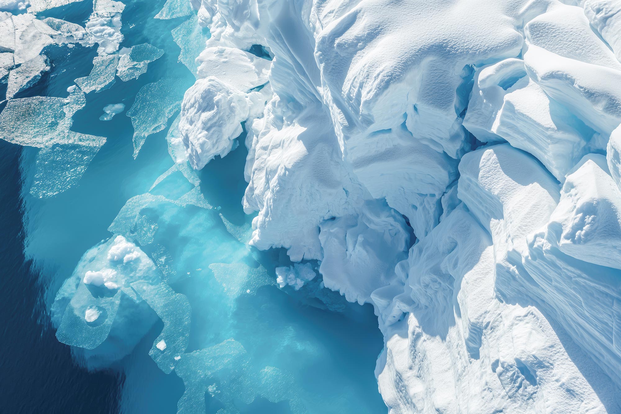
“The grounding line is where continental ice meets the ocean, and measuring the movement of grounding lines with satellite-based synthetic aperture radar has been our gold standard for documenting ice sheet stability,” said lead author Eric Rignot, UC Irvine Distinguished Professor and Donald Bren Professor of Earth system science. “We’ve known it’s critically important for 30 years, but this is the first time we’ve mapped it comprehensively across all of Antarctica over such a long time span.”
On average, Antarctica’s ice sheet has pulled back from its grounding line by 442 square kilometers (about 171 square miles) per year. The most significant changes occurred in the Amundsen Sea and Getz regions of West Antarctica, where glaciers retreated between 10 and about 40 kilometers (6 to about 25 miles).
Pine Island Glacier retreated 33 kilometers (about 20 miles). Thwaites Glacier retreated 26 kilometers (about 16 miles). Smith Glacier retreated 42 kilometers (about 26 miles), marking one of the largest shifts observed in the study.
“Where warm ocean water is pushed by winds to reach glaciers, that’s where we see the big wounds in Antarctica,” explained Rignot, who’s also a senior research scientist at NASA’s Jet Propulsion Laboratory. “It’s like the balloon that’s not punctured everywhere, but where it is punctured, it’s punctured deep.”
Satellite Data and Commercial Partnerships
To build the long term record, researchers combined data from numerous satellite missions. These included the European Space Agency’s ERS-1/2 and Sentinel-1; Canada’s RADARSAT 1, RADARSAT 2, and RADARSAT Constellation Mission; Japan’s ALOS/PALSAR-2; Italy’s COSMO-SkyMed; the German Aerospace Center’s TerraSAR-X; and Argentina’s SAOCOM.
According to co-author Bernd Scheuchl, a UC Irvine project scientist in Earth system science, the project marks a major milestone for NASA’s Commercial Satellite Data Acquisition program. It is the first large-scale success in integrating commercial synthetic aperture radar data into polar research.
The team used data provided through NASA CSDA by companies such as Airbus U.S. and Irvine-based ICEYE US. The researchers also independently obtained information from Finland’s ICEYE Ltd., which has collaborated with UC Irvine for years, including on studies tracking the rapid decline of Thwaites Glacier.
“This work shows how commercial SAR data can be used to contribute to the virtual SAR constellation by augmenting the program of record from agency-run missions,” Scheuchl said. “The ability to access daily observations in critical areas using commercial assets, combined with decades of international space agency data with large-area coverage, has opened a new era in polar monitoring.”
Unresolved Mysteries in the Antarctic Peninsula
Scientists attribute most grounding line retreat to warm ocean water flowing beneath floating ice shelves and thinning the ice from below. However, the northeastern Antarctic Peninsula presents a puzzle.
“A lot of these places have warm ocean water in proximity, but on the east coast of the peninsula, there’s substantial retreat, and we don’t have evidence for warm water,” Rignot said. “Something else is acting – it’s still a question mark.”
Several ice shelves in this region collapsed before the study period began. Since then, glaciers such as Edgeworth, which retreated 16 kilometers (about 10 miles), along with Boydell, Sjogren, Bombardier and Dinsmoor, have continued to shrink significantly. The Hektoria Glacier retreated 21 kilometers (about 13 miles), Green Glacier 16 kilometers (about 10 miles), and Evans Glacier 9 kilometers (about 6 miles) beyond their 1996 grounding line positions.
Implications for Sea Level Rise Modeling
This continent-wide grounding line record offers a critical benchmark for the next generation of ice sheet models that aim to forecast future sea level rise.
“Models have to demonstrate they can match this 30-year record to claim credibility for their projections,” Rignot noted. “That’s the real value of this observational record: knowing that this grounding line migration has happened. If a model can’t reproduce this record, the modeling team will need to go back to the drawing board and figure out what boundary condition or physics are missing.”
The results also clarify ongoing debates about Antarctica’s mass balance. Confirming that 77 percent of the coastline remains stable helps reconcile conflicting measurements in East Antarctica. At the same time, the study pinpoints where ice loss is actively reshaping other parts of the continent.
“The flip side is that we should perhaps feel fortunate that all of Antarctica isn’t reacting right now, because we would be in far more trouble,” Rignot said. “But that could be the next step.”
Reference: “Thirty years of glacier grounding line retreat in Antarctica” by Eric Rignot, Bernd Scheuchl, Jean Baptiste Barre, Virginia Brancato, Laurane Charrier, Hanning Chen, Enrico Ciraci, Andy Dinh, Sam Herreid, Seongsu Jeong, Xin Li, Thomas Mitchell, Yara Mohajerani, Sina Shamsian, Valentyn Tolpekin, Isabella Velicogna and Michael Wollersheim, 2 March 2026, Proceedings of the National Academy of Sciences.
DOI: 10.1073/pnas.2524380123
The research team included scientists from UC Irvine, NASA’s Jet Propulsion Laboratory, France’s University Grenoble Alpes, and the University of Washington in Seattle, as well as collaborators from ICEYE Ltd. in Uusimaa, Finland, and ICEYE U.S. in Irvine. Funding was provided by NASA.
Never miss a breakthrough: Join the SciTechDaily newsletter.
Follow us on Google and Google News.
8 Comments
“Scientists attribute most grounding line retreat to warm [buoyant] ocean water flowing beneath floating ice shelves and thinning the ice from below.”
In other words, it ISN’T anthropogenic CO2 uniformly warming the atmosphere that is responsible for melting ice. And, in fact, if the melting is the result of up-welling deep water, it probably hasn’t been in contact with the atmosphere for hundreds of years!
It is well-known that there are something like 90 under-ice volcanoes and West Antarctic (including the notable peninsula) is also known to be geothermally anomalous over a large area, unlike East Antarctica. Yet, they claim puzzlement: “However, the northeastern Antarctic Peninsula presents a puzzle. ‘A lot of these places have warm ocean water in proximity, but on the east coast of the peninsula, there’s substantial retreat, and we don’t have evidence for warm water,’ Rignot said. ‘Something else is acting – it’s still a question mark.’” If someone is committed to the consensus paradigm of anthropogenic emissions as the driver of melting, it might create internal conflict to even consider natural sources, let alone objectively explore the possibility.
” And, in fact, if the melting is the result of up-welling deep water, it probably hasn’t been in contact with the atmosphere for hundreds of years! ”
Holy invented facts, Batman! Your cherry-picked reading missed the following – “Where warm ocean water is pushed by winds to reach glaciers, that’s where we see the big wounds in Antarctica,” explained Rignot…
Not only is the warm water coming into contact with the wind (meaning, that it is at the surface, genius), there is a curious lack of “upwelling” anywhere in the article.
Holy Cherry Picking, Robin! What you missed is that the explanation you quoted only addresses grounding line retreat for about 23% of the Antarctic coast and doesn’t apply to the Antarctic Peninsula; they say, “A lot of these places have warm ocean water in proximity, but on the east coast of the peninsula, there’s substantial retreat, and we don’t have evidence for warm water.”
Yes, it IS curious that the authors don’t mention “up-welling” because if the winds are blowing off shore and moving water away from Antarctica, as with Foehn winds, then up-welling WILL replace the water blown away. Just because the authors don’t mention up-welling doesn’t mean it isn’t happening! It only means they didn’t mention it, genius. During the cold Winter, the winds are often westerlies that are reflected in the circumpolar vortex, albeit they are strongest at high altitudes. However, in the middle of Winter, when the water surface is exposed to very cold temperatures, the water freezes and expels dense cold brines that sink and seem to not be effective in melting the underside of the glacial shelves. Thus, the ice acts to help slow the loss of heat, but also armors the water from the effect of winds.
If the Summer winds are driving surface water towards Antarctica, in the absence of pack ice, the water may pile up off shore. But then one is confronted with the question about how the density difference between buoyant ‘warm’ Summer surface water and the cold, denser Antarctic water allows it to be pushed under the shelf ice. I’m not sure what to expect either, but ‘I’m asking for a friend’ who noticed that the authors didn’t talk about these things.
Your deprecating tone isn’t appreciated. If you had solid facts to present, that would have been sufficient and I would have acknowledged I had overlooked some things. However, Cherry Picking and insults don’t earn you an apology.
“The flip side is that we should perhaps feel fortunate that all of Antarctica isn’t reacting right now, because we would be in far more trouble,”
The unstated assumptions are that the melting is anthropogenic in origin and therefore there is the potential to do something about it. Thus is the hope derived from blind faith.
If one is looking to explain some phenomenon in terms of a single (or very small number) driving force, then the most probable candidate is one that has the potential to act uniformly on 100% of the susceptible physiographic features, not just 23% of them. Instead, the fact that only a minority of the glaciers are experiencing grounding-line retreat, and they are almost all in West Antarctica, should be a red flag to re-examine all of one’s assumptions. Otherwise, one has to violate Occam’s Razor and start inventing reasons why the majority of the shelf ice is apparently unaffected! Reality is what happens, not what one wants to happen.
Big numbers, such as equivalents of areas, may impress the easily impressionable. However, they do little to provide insight on complex dynamic systems. If one is interested in actually providing useful information, percentages or ratios would be more appropriate metrics.
What the F is a “Los Angeles size city”? A new measurement unit? A unit of area? A unit of volume?
Why can’t you illiterates finally learn to use the metric system for F’s sake?
“And, in fact, if the melting is the result of up-welling deep water, it probably hasn’t been in contact with the atmosphere for hundreds of years! ”
Are not ifs and probables condemned as lawyers’ words? Or at least mere supposition? I don’t know the depth to basement below the West Antarctic ice-sheet or how much water is under the ice-sheet, or the hydrodynamics going on in regard to the sub-glacial water, but one would imagine that whatever high geothermal gradient there is in that part of the world it would be relatively localised to hot-spots and have little effect on deep ocean waters coming from the more deep oceans. But then again, a local 0.5 or 1 degree C geothermal warming of parts of those deep, alleged by me oceanic, waters getting under the ice would be rather important. And would lead to spottiness in glacial retreat. And that too, is supposition on my part. There lies a nice broad research project.
Rob, my previous complaints about using “could” and “may” were in response to authors presenting scenarios without numeric estimates of the probabilities of their conjectures. My use of “if” is acknowledging that one is confronted with a binary outcome of true or false for the sake of a logical argument, not a prediction of what the future holds. As to my use of the word “probably,” I’m acknowledging that I don’t know how long any body of water has been entrained in an ocean current and I’m not pretending to know. I’m not reporting on a research project measuring something. What I am saying is that it is generally accepted that the cold abyssal currents take about a millennium to transit from the cold polar regions to the surface in the tropical zones. Thus, the cold currents can be out of communication with the atmosphere for hundreds of years, and for the water that doesn’t partake of the cold-to-warm circulation, it could be much longer, and I’m using that word in the context of what I have previously claimed, namely that “could” only means that it is not impossible.
Thanks to our nuclear submarine fleet, there are people who can answer some of your questions about the southern oceans bathymetry, although they may not be able to legally divulge the information. Even so, much of the detail isn’t even known. That is why I take issue with people who demonstrate Mark Twain’s quip about science: “There is something fascinating about science. One gets such wholesale returns of conjecture out of such a trifling investment of fact.”