Close Menu
    Facebook X (Twitter) Instagram
    SciTechDaily
    • Biology
    • Chemistry
    • Earth
    • Health
    • Physics
    • Science
    • Space
    • Technology
    Facebook X (Twitter) Pinterest YouTube RSS
    SciTechDaily
    Home»Earth»Are You Living on the Edge? New USGS Map Shows Landslide Risks
    Earth

    Are You Living on the Edge? New USGS Map Shows Landslide Risks

    By Steven Sobieszćzyk, U.S. Geological SurveySeptember 16, 20241 Comment3 Mins Read
    Facebook Twitter Pinterest Telegram LinkedIn WhatsApp Email Reddit
    Share
    Facebook Twitter LinkedIn Pinterest Telegram Email Reddit
    US Landslide Susceptibility Map
    Landslides are a common hazard in the US. In fact, nearly 44% of the country could experience one, potentially catastrophically. A new national landslide susceptibility map from the U.S. Geological Survey shows where they’re most likely to happen. Credit: U.S. Geological Survey

    The U.S. Geological Survey has developed a new nationwide landslide susceptibility map, showing that nearly half the country is at risk of landslides.

    This map, built using an inventory of nearly 1 million previous landslides and high-resolution elevation data, provides a detailed, county-by-county analysis to aid in risk reduction and land-use planning. It not only identifies hazardous areas but also spots where further mapping is needed to enhance landslide preparedness.

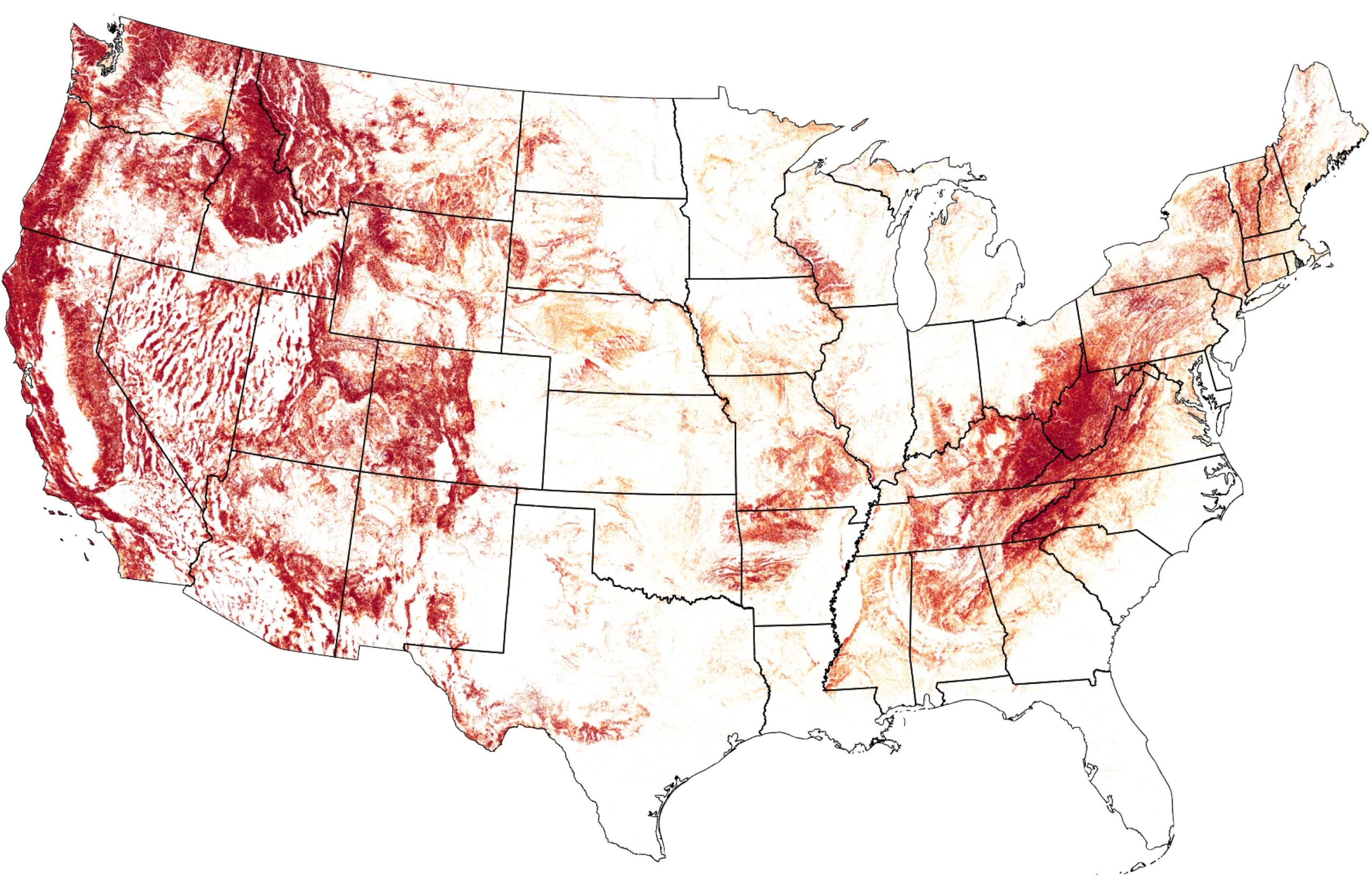
    New Landslide Susceptibility Map

    The U.S. Geological Survey has released a new nationwide landslide susceptibility map that indicates nearly 44% of the U.S. could potentially experience landslide activity. The new assessment provides a highly detailed, county-by-county picture of where these damaging, disruptive, and potentially deadly geologic hazards are more likely as well as areas where landslide hazards are negligible.

    The new map will support risk-reduction and land-use planning efforts by showing where potentially unstable areas are so planners and engineers can better prioritize and mitigate future landslide hazards.

    United States Landslide Susceptibility Map
    Map of the United States including Hawaii, Alaska, and Puerto Rico showing landslide susceptibility from yellow (fewer landslides) to red (more landslides), where the areas without shading represent negligible potential for landslides. Higher landslide susceptibility is evident across most mountainous terrain within the U.S., but there is also considerable potential scattered throughout other areas of the country. Credit: U.S. Geological Survey

    Landslide Susceptibility Across the U.S.

    “This new national landslide susceptibility map addresses an important but difficult question: which areas across the entire U.S. are prone to landslides?” said Ben Mirus, USGS research geologist. “We are excited that it is now publicly available to help everyone be more prepared – to be a more hazard-ready nation.”

    Previously, detailed landslide maps were only developed for a few areas of the U.S. where the landslide risks were considered high, but this map expands the assessment to include many other hazardous areas around the country where there was a limited understanding of landslide potential.

    Mirus and team used an inventory of nearly 1 million previous landslides, high-resolution national elevation data from the USGS 3D Elevation Program, and advanced computing to build their comprehensive landslide susceptibility model. The resulting map of the contiguous U.S., Alaska, Hawaii, and Puerto Rico zeroes in on landslide locations by using much higher resolution data than existing continental and global landslide maps.

    Future Applications and Needs

    The new map can also be used to identify areas where more landslide mapping is needed and how the improvements can better inform landslide mitigation.

    Reference: “Parsimonious High-Resolution Landslide Susceptibility Modeling at Continental Scales” by Benjamin B. Mirus, Gina M. Belair, Nathan J. Wood, Jeanne Jones and Sabrina N. Martinez, 11 September 2024, AGU Advances.
    DOI: 10.1029/2024AV001214

    Never miss a breakthrough: Join the SciTechDaily newsletter.
    Follow us on Google and Google News.

    Geological Survey
    Share. Facebook Twitter Pinterest LinkedIn Email Reddit

    Related Articles

    Is It Erupting Soon? Scientists Solve Mystery of Rumbling “Zombie” Volcano

    Seismic Shifts: USGS Unveils Groundbreaking Earthquake Hazard Map

    Dramatic Melting of Antarctica Under Record Heat Caught by Shocking NASA Satellite Images

    1 Comment

    1. ron on September 17, 2024 6:20 pm

      Steep slopes/soils behind/above brother’s & cousin’s houses are likely higher Risk than Soils on gentle to moderate slopes. Can USGS use the detailed Soil Surveys already completed by USDA & the Land Grant Universities???

      Reply
    Leave A Reply Cancel Reply

    • Facebook
    • Twitter
    • Pinterest
    • YouTube

    Don't Miss a Discovery

    Subscribe for the Latest in Science & Tech!

    Trending News

    Scientists May Have Found the Key to Jupiter and Saturn’s Moon Mystery

    Scientists Uncover Brain Changes That Link Pain to Depression

    Saunas May Do More Than Raise Body Temperature – They Activate Your Immune System

    Exercise in a Pill? Metformin Shows Surprising Effects in Cancer Patients

    Hidden Oceans of Magma Could Be Protecting Alien Life

    New Study Challenges Alzheimer’s Theories: It’s Not Just About Plaques

    Artificial Sweeteners May Harm Future Generations, Study Suggests

    Splashdown! NASA Artemis II Returns From Record-Breaking Moon Mission

    Follow SciTechDaily
    • Facebook
    • Twitter
    • YouTube
    • Pinterest
    • Newsletter
    • RSS
    SciTech News
    • Biology News
    • Chemistry News
    • Earth News
    • Health News
    • Physics News
    • Science News
    • Space News
    • Technology News
    Recent Posts
    • This Strange Material Can Turn Superconductivity on and off Like a Switch
    • Scientists Discover Game-Changing New Way To Treat High Cholesterol
    • Breakthrough Drug Delays Rheumatoid Arthritis for Years After Treatment Ends
    • This Small Change to Your Exercise Routine Could Be the Secret to Living Longer
    • Physicists Discover a Strange New Kind of One-Dimensional Particle
    Copyright © 1998 - 2026 SciTechDaily. All Rights Reserved.
    • Science News
    • About
    • Contact
    • Editorial Board
    • Privacy Policy
    • Terms of Use

    Type above and press Enter to search. Press Esc to cancel.