
Close Menu
    Facebook X (Twitter) Instagram
    SciTechDaily
    • Biology
    • Chemistry
    • Earth
    • Health
    • Physics
    • Science
    • Space
    • Technology
    Facebook X (Twitter) Pinterest YouTube RSS
    SciTechDaily
    Home»Earth»Epic Rainfall Turns Australia’s Outback Into a Vast Wetland Network
    Earth

    Epic Rainfall Turns Australia’s Outback Into a Vast Wetland Network

    By Lindsey Doermann, NASA Earth ObservatoryDecember 1, 2024No Comments3 Mins Read
    Facebook Twitter Pinterest Telegram LinkedIn WhatsApp Email Reddit
    Share
    Facebook Twitter LinkedIn Pinterest Telegram Email Reddit
    Saturated Northern Australia 2024 Annotated
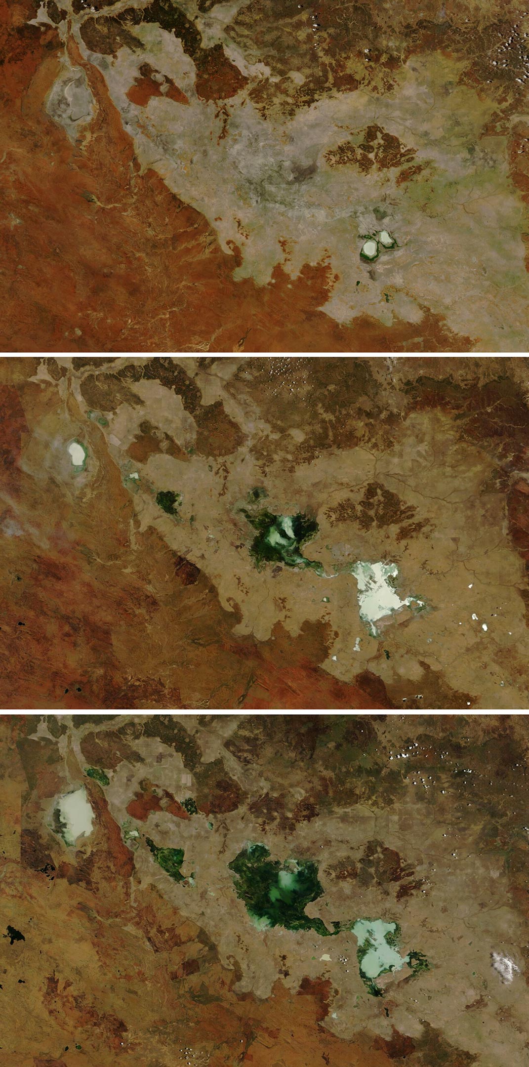
    Satellite images show Tarrabool Lake and Lake Sylvester in Australia’s Northern Territory expanded significantly from November 18, 2022, to November 22, 2024.

    After two particularly wet years, large ephemeral lakes in the Barkly Tableland region of Northern Australia were still flooded as the 2024–2025 rainy season got underway.

    Consecutive seasons of heavy rainfall have transformed the ephemeral lakes of Australia’s Barkly Tableland, with Tarrabool and Sylvester Lakes expanding significantly, evidenced by satellite data from NASA’s MODIS. The area has become an essential habitat for waterbirds.

    Rainfall and Lake Expansion in Australia’s Northern Territory

    The Barkly Tableland in Australia’s Northern Territory is a vast region of grasslands and cattle ranches. During particularly heavy rainy seasons, this arid landscape transforms as ephemeral lakes swell, sometimes covering thousands of square kilometers.

    Back-to-back wet years in 2022–2023 and 2023–2024 fueled significant expansions of Tarrabool Lake and Lake Sylvester. These rainy seasons, which run from October to April, ranked among the top ten wettest in northern Australia since 1900. According to the Australian Bureau of Meteorology, rainfall in this part of the Northern Territory was classified as “very much above average” in both years.

    Satellite Observations of Ephemeral Lakes

    This series of images, acquired by the MODIS (Moderate Resolution Imaging Spectroradiometer) on NASA’s Aqua and Terra satellites, shows the evolution of Tarrabool Lake and Lake Sylvester between November 2022 and November 2024. Near the start of the wet season in 2022 (left), only Lake Sylvester appears to contain any water. Rains later in the season, including several days of downpours in early March 2023, helped fill in the lakes enough that water persisted into the start of the next rainy season.

    In November 2023 (center), Tarrabool Lake is visible where the land was previously dry, and Lake Sylvester has expanded and merged with adjacent ephemeral lakes. The ensuing 2023–2024 wet season included the tenth-wettest January and second-wettest March on record for northern Australia. Contributing to that, severe tropical cyclone Megan brought widespread rainfall to the region in March. The Northern Territory’s Barkly Highway flooded enough in places following that event for fish to be seen crossing the road.

    Tarrabool Lake Australia 2024 Annotated
    Satellite image of Tarrabool Lake, Tarrabool Lake, Corella Lake, and Lake Deburgh captured on October 30, 2024, by the Operational Land Imager on the Landsat 8.

    Record-Breaking Rainfall Events

    Early in the 2024–2025 wet season, the lakes covered more area than at similar times in the past two years. The OLI (Operational Land Imager) on the Landsat 8 satellite acquired this image showing their extent on October 30, 2024. Lake Sylvester had merged with nearby Corella Lake and Lake Deburgh. Likewise, the water in Tarrabool Lake had connected with an area known as Eva Downs Swamp to the northwest to form a single freshwater wetland. Both systems are considered important areas for waterbirds. Together, when fully flooded, the wetlands span approximately 4,750 square kilometers (1,830 square miles), nearly the size of the state of Delaware.

    According to a report from the Australian Bureau of Meteorology and the Commonwealth Scientific and Industrial Research Organisation (CSIRO), the amount of annual rainfall in the Barkly region has trended upward in recent decades, and evaporation rates have declined. Still, rainfall is highly variable from year to year. It falls more reliably from December to March, when monsoonal weather patterns tend to form.

    NASA Earth Observatory images by Lauren Dauphin, using MODIS data from NASA EOSDIS LANCE and GIBS/Worldview, and Landsat data from the U.S. Geological Survey.

    Never miss a breakthrough: Join the SciTechDaily newsletter.
    Follow us on Google and Google News.

    NASA NASA Earth Observatory Rain Weather
    Share. Facebook Twitter Pinterest LinkedIn Email Reddit

    Related Articles

    Half a Year of Rain Falls in One Day: Roswell’s Historic Downpour

    Deadly and Destructive Flash Floods: Tracing Hurricane Helene’s Hydrological Havoc

    China’s Unrelenting Flooding: 2020 Summer Monsoon Season Delivers Historic Rainfall

    Satellite Maps Shows Signs of Drought in European Groundwater

    Meteorologists Shocked as Heat and Fire Scorches Siberia

    Unusual “Volcano Track” Clouds Investigated

    After Two Years of Drought Ends, Southeastern Australia Turns Green

    “Wedge Failure” Landslide in Alaska

    Muddy Flooding After Catastrophic Dam Failures in Michigan Seen From Space

    Leave A Reply Cancel Reply

    • Facebook
    • Twitter
    • Pinterest
    • YouTube

    Don't Miss a Discovery

    Subscribe for the Latest in Science & Tech!

    Trending News

    Don’t Miss: A Brilliant Venus and Glowing Harvest Moon Light Up the Sky

    New Twist on the Einstein Problem Reveals Unexpected Physics

    JWST Captures Stunning Evidence of How Supermassive Black Holes Feed

    Early Exercise May Permanently Change How Much Energy the Body Uses To Move

    New Molecule Wipes Out Aggressive Lymphoma Tumors in Mice in Just 11 Days

    The Human Family Tree May Need a Major Rewrite

    Scientists Find a Surprising Cancer-Fighting Effect in Dark Sweet Cherries

    New AI Detects Hidden Warning Signs of Solar Eruptions Hours Before They Emerge

    Follow SciTechDaily
    • Facebook
    • Twitter
    • YouTube
    • Pinterest
    • Newsletter
    • RSS
    SciTech News
    • Biology News
    • Chemistry News
    • Earth News
    • Health News
    • Physics News
    • Science News
    • Space News
    • Technology News
    Recent Posts
    • Vagus Nerve Stimulation Could Unlock the Brain’s Hidden Learning Potential
    • Your Mother’s Age May Leave a Biological Mark That Lasts for Generations
    • Women Who Ate More Antioxidants Had Strikingly Lower Rates of Cervical Cancer
    • A Hidden Hormone Disorder May Be Driving Millions of High Blood Pressure Cases
    • This Self-Rebuilding Electrode Could Supercharge Green Hydrogen Production
    Copyright © 1998 - 2026 SciTechDaily. All Rights Reserved.
    • Science News
    • About
    • Contact
    • Editorial Board
    • Privacy Policy
    • Terms of Use

    Type above and press Enter to search. Press Esc to cancel.