Big waves have doubled since the 1950s, possibly due to shifting climate.
A new study links atmospheric shifts to prolonged spells of extreme winter conditions in North America and Europe, with these extreme patterns doubling since the 1960s. These patterns often synchronize across the two continents, causing significant disruptions.
Climate Change and Extreme Weather Patterns
Winter is coming—eventually. And while the earth is warming, a new study suggests that the atmosphere is being pushed around in ways that cause long bouts of extreme winter cold or wet in some regions.
The study’s authors say they have identified giant meanders in the global jet stream that bring polar air southward, locking in frigid or wet conditions concurrently over much of North America and Europe, often for weeks at a time. Such weather waves, they say, have doubled in frequency since the 1960s. In just the last few years, they have killed hundreds of people and paralyzed energy and transport systems.
The new paper was published this week in the Bulletin of the American Meteorological Society.
Understanding Jet Streams and Weather Anomalies
“Even though winters are getting milder on average, it’s happening at the expense of increasingly devastating heat extremes in the warm season,” said author Kai Kornhuber, an adjunct scientist at Columbia University’s Lamont-Doherty Earth Observatory. “A hundred years from now, we will probably not have to worry as much about extreme cold, because everything is getting warmer. But today and going forward, cold is still a very relevant hazard.”
The jet stream is a fast-moving river of air that continuously circles the Northern Hemisphere from east to west. It generally flows within relatively straight boundaries, segregating cold polar air masses from the midlatitudes, but at times it can naturally develop big wobbles. Some scientists think these wobbles are increasing in size and frequency due to rapid warming in the Arctic that is far out proportion to more southerly regions; this destabilizes the system, generating winds that break down the north-south barrier, they say. Given the right conditions, certain of these wobbles can become amplified into symmetrical waves that then lock in place across the globe, somewhat similar to the vibrations that produce a constant musical pitch. These are called Rossby waves.
Rossby Waves and Weather Impact
In a 2019 study, Kornhuber and colleagues showed that a repeating Rossby wave pattern known as a wave-7—that is, seven giant peaks and seven matching troughs spanning the globe—draws warm, dry air from the subtropics up to the midlatitudes, causing concurrent summer heat waves and droughts in predictable parts of North America, Europe and Asia. These can cause widespread, simultaneous crop losses in important breadbasket regions, the study said.
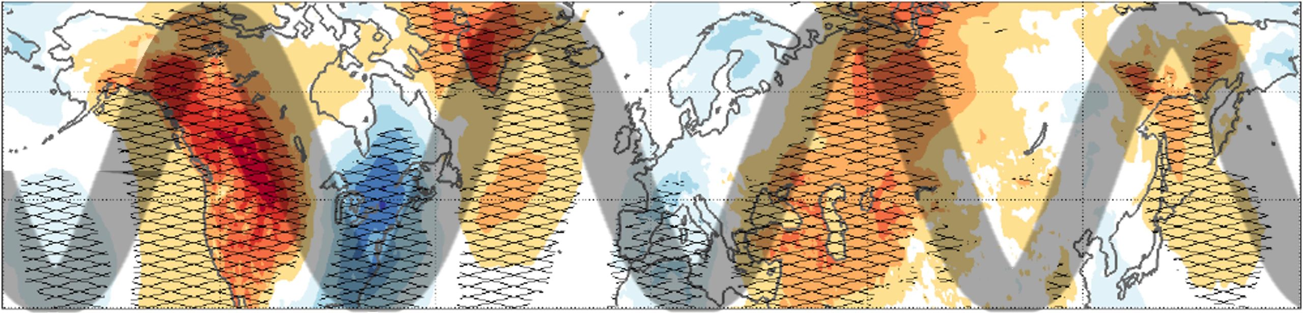
The newer paper shows more or less the other side of the coin. A winter pattern known as a wave-4—globally, four peaks and four matching troughs — tend to lock in place. The authors say that when this happens, the chances of extreme cold or wet in the trough triples. At the same time, abnormally warm or dry conditions may develop in the peaks.
The most recent major wave-4 iteration brought a February 2021 cold wave to much of Canada, the United States, and even northern Mexico. Temperatures fell as much as 50 degrees F below average as far south as the U.S. Gulf Coast. Parts of the Deep South saw rare snowfall. Hardest hit: Texas, where record cold paralyzed natural gas pipelines and other energy infrastructure, knocking out much of the electricity grid and causing homes and businesses to go dark and freeze. All told, at least 278 people were killed directly or indirectly by the cold wave, and there was nearly $200 billion in damage. A similar though less destructive event caused a January-February 2019 cold snap in the eastern United States, killing more than 20 people.
Synchronized Weather Events in North America and Europe
The same pattern often hits on the other side of the Atlantic at the same time, usually most most extreme in southwestern Europe and Scandinavia. The January-February 2019 event brought extreme low temperatures to both southern France and Sweden. At the same time, by sweeping in moist air from the Atlantic, it caused extreme precipitation and flooding across many areas in central and eastern Europe. Similar events took place in Europe in 2013 and 2018.
The researchers say that 50 years ago, such concurrent waves took hold on average only once each winter. The numbers vary year to year, but now the average has risen to twice a year.
“This adds to the growing evidence that extreme weather over North America and Europe are often synchronized,” said the study’s other author, Gabriele Messori of Sweden’s Uppsala University. Messori published a paper earlier this year noting repeated examples of this phenomenon, and hypothesizing a connection to large-scale atmospheric circulation patterns.
Looking Ahead
Kornhuber said the exact mechanisms that cause the emergence of the wave-4 pattern require further research, but he suspects it starts with periodic changes in oceanic conditions over parts of the Pacific that, under the right circumstances, can trigger a global chain reaction. Pinning down that mechanism might allow scientists to better predict the cold or wet waves, he said.
Kornuber said that there is growing evidence of a connection between warming climate and the summer meanders that bring heat waves; however, the winter waves are still a matter of intense scientific discourse. Scientists are currently investigating several possible mechanisms that could point to a climate connection, and how things might evolve in the future.
Kornhuber noted that a study he coauthored earlier this year showed that climate models still struggle to reproduce the most extreme regional weather anomalies associated with these larger-scale patterns even in summer; this could lead to underestimations of potential weather-related crop losses in particular areas. He said upcoming work will focus on investigating whether the worst extreme are linked to human causes or just natural variability.
Reference: “Recent Increase in a Recurrent Pan-Atlantic Wave Pattern Driving Concurrent Wintertime Extremes” by Kai Kornhuber and Gabriele Messori, 2 October 2023, Bulletin of the American Meteorological Society.
DOI: 10.1175/BAMS-D-21-0295.1
Never miss a breakthrough: Join the SciTechDaily newsletter.
Follow us on Google and Google News.
2 Comments
“The jet stream is a fast-moving river of air that continuously circles the Northern Hemisphere from east to west.”
Wrong direction. This is quite an error. Apparently, as with most publications these days, the proofreader is nowhere to be found.
Good catch!