Scientists detect rejuvenated uplift near South Sister volcano.
Using satellite imagery and sophisticated GPS instruments, Cascades Volcano Observatory geophysicists have detected a subtle increase in the rate of uplift of the ground surface about 3 miles (5 km) west of South Sister volcano, Oregon. Episodes of increased uplift have been observed in this area before, and the volcano’s alert level and color code remain at NORMAL / GREEN.
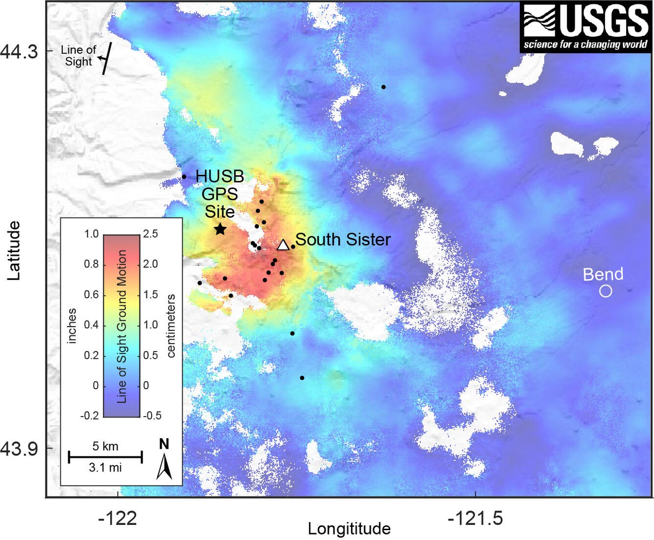
Data from satellite radar images show an uplift of about 0.9 inches or 2.2 cm (about the width of an adult’s thumb) occurred between the summer of 2020 and August 2021 across an area 12-mile (20-km) in diameter. GPS data from a volcano monitoring station near the center of uplift measured at least 0.2 inches (0.5 cm) of uplift since August 2021.
Additionally, seismologists observed brief bursts of small earthquakes in October 2021, December 2021, and January 2022. Most of these shallow earthquakes are too small to locate precisely; those located are inside the uplifted area.
USGS geologist Dan Dzurisin is near Sisters, in Central Oregon, to set up portable GPS monitoring equipment to track something that’s been going on for 25 years and still goes on today. It’s uplift, a subtle rise in the ground’s surface, in an area west of South Sister volcano.
Uplift began in the mid-1990s and was first observed in radar satellite imagery. The USGS, working with the Forest Service, installed permanent monitoring stations to track the rate at which the area was uplifting.
In addition, every summer Dr. Dzurisin sets out GPS stations to collect ground deformation data. While radar satellites provide a picture of the entire area, these temporary GPS stations give very accurate measurements of how individual points have moved. Dr. Dzurisin and summer intern Natalea Cohen show you how they set up the semi-permanent GPS stations and talk about the importance of the work.
One thing that can cause uplift is magma moving around underground, or in particular, magma rising from greater depth in the earth up to a shallower depth, which forces the surface to move upward in a very broad area. Remarkably, this process has caused very few earthquakes. So, if you’re not using satellite radar data or some other form of data to look for it, episodes like this may have happened in other places and maybe in Central Oregon as well, and we just didn’t know it.
USGS scientists are monitoring this activity as carefully and thoroughly as they can, and will continue to monitoring the area for as long as it goes on, to gain a greater understanding of this process.
![]()
Uplift occurred in the same general region in the mid-1990s. During the 25 years between 1995 and 2020, the area rose approximately 12 inches or 30 cm (the height of a 2-liter soda bottle) at its center. Although the current uplift rate is slower than the maximum rate measured in 1999-2000, it is distinctly faster than the rate observed for several years before 2020.

The uplift is attributed to small pulses of magma accumulating at roughly 4 miles (7 km) below the ground surface. While any magmatic intrusion could eventually lead to a volcanic eruption, an eruption would likely be preceded by detectable and more vigorous earthquakes, ground movement (deformation), and geochemical changes. In general, as magma moves upward during an intrusion, it causes continued or accelerated uplift, fractures rock to generate swarms of earthquakes, and releases significant amounts of volcanic gases, such as carbon dioxide. We do not detect any of these signs currently.
CVO scientists will closely monitor data in the coming months and issue further updates as warranted.
Never miss a breakthrough: Join the SciTechDaily newsletter.
Follow us on Google and Google News.
4 Comments
Hey Google, how did you know I wanted to read an article about “growing bulges?”
Has anyone noticed the bulge on the side of mount hood? Me and my husband have been watching it for almost 6 years and it appears to keep getting bigger in size it is quite visible on a clear day. Didnt know if anybody was aware of it or not
I thought Mt Hood and Mt St Helens were two of the three sisters (don’t know the third). Are they unrelated volcanoes?
YUP..NOT RELATED…MANY MILES APART..HMMM ACTUALLY THE VISIBLE ID’S ARE FAR APART…don’t know if the hi tech folks have determined if there’s a connective river of lava between HOOD and the SISTERS and / or Mt. Bachelor . That’s a good question tho. Makes one wonder Jay.