A newly published study provides the first complete view of the Yellowstone magmatic system from the mantle plume to the upper crust, revealing a gigantic magma reservoir beneath the previously known magma chamber.
University of Utah seismologists discovered and made images of a reservoir of hot, partly molten rock 12 to 28 miles (19 to 45 kilometers) beneath the Yellowstone supervolcano, and it is 4.4 times larger than the shallower, long-known magma chamber.
The hot rock in the newly discovered, deeper magma reservoir would fill the 1,000-cubic-mile (4,000-cubic-kilometers) Grand Canyon 11.2 times, while the previously known magma chamber would fill the Grand Canyon 2.5 times, says postdoctoral researcher Jamie Farrell, a co-author of the study published online today in the journal Science.
“For the first time, we have imaged the continuous volcanic plumbing system under Yellowstone,” says first author Hsin-Hua Huang, also a postdoctoral researcher in geology and geophysics. “That includes the upper crustal magma chamber we have seen previously plus a lower crustal magma reservoir that has never been imaged before and that connects the upper chamber to the Yellowstone hotspot plume below.”
Contrary to popular perception, the magma chamber and magma reservoir are not full of molten rock. Instead, the rock is hot, mostly solid and spongelike, with pockets of molten rock within it. Huang says the new study indicates the upper magma chamber averages about 9 percent molten rock – consistent with earlier estimates of 5 percent to 15 percent melt – and the lower magma reservoir is about 2 percent melt.
So there is about one-quarter of a Grand Canyon’s worth of molten rock within the much larger volumes of either the magma chamber or the magma reservoir, Farrell says.
This video by the National Science Foundation summarizes a study published online in the journal Science on April 23, 2015, led by seismologists at the University of Utah.
No increase in the danger
The researchers emphasize that Yellowstone’s plumbing system is no larger – nor closer to erupting – than before, only that they now have used advanced techniques to make a complete image of the system that carries hot and partly molten rock upward from the top of the Yellowstone hotspot plume – about 40 miles (64 kilometers) beneath the surface – to the magma reservoir and the magma chamber above it.
“The magma chamber and reservoir are not getting any bigger than they have been, it’s just that we can see them better now using new techniques,” Farrell says.
Study co-author Fan-Chi Lin, an assistant professor of geology and geophysics, says: “It gives us a better understanding of the Yellowstone magmatic system. We can now use these new models to better estimate the potential seismic and volcanic hazards.”
The researchers point out that the previously known upper magma chamber was the immediate source of three cataclysmic eruptions of the Yellowstone caldera 2 million, 1.2 million, and 640,000 years ago, and that isn’t changed by the discovery of the underlying magma reservoir that supplies the magma chamber.
“The actual hazard is the same, but now we have a much better understanding of the complete crustal magma system,” says study co-author Robert B. Smith, a research and emeritus professor of geology and geophysics at the University of Utah.
The three supervolcano eruptions at Yellowstone – on the Wyoming-Idaho-Montana border – covered much of North America in volcanic ash. A supervolcano eruption today would be cataclysmic, but Smith says the annual chance is 1 in 700,000.
Before the new discovery, researchers had envisioned partly molten rock moving upward from the Yellowstone hotspot plume via a series of vertical and horizontal cracks, known as dikes and sills, or as blobs. They still believe such cracks move hot rock from the plume head to the magma reservoir and from there to the shallow magma chamber.
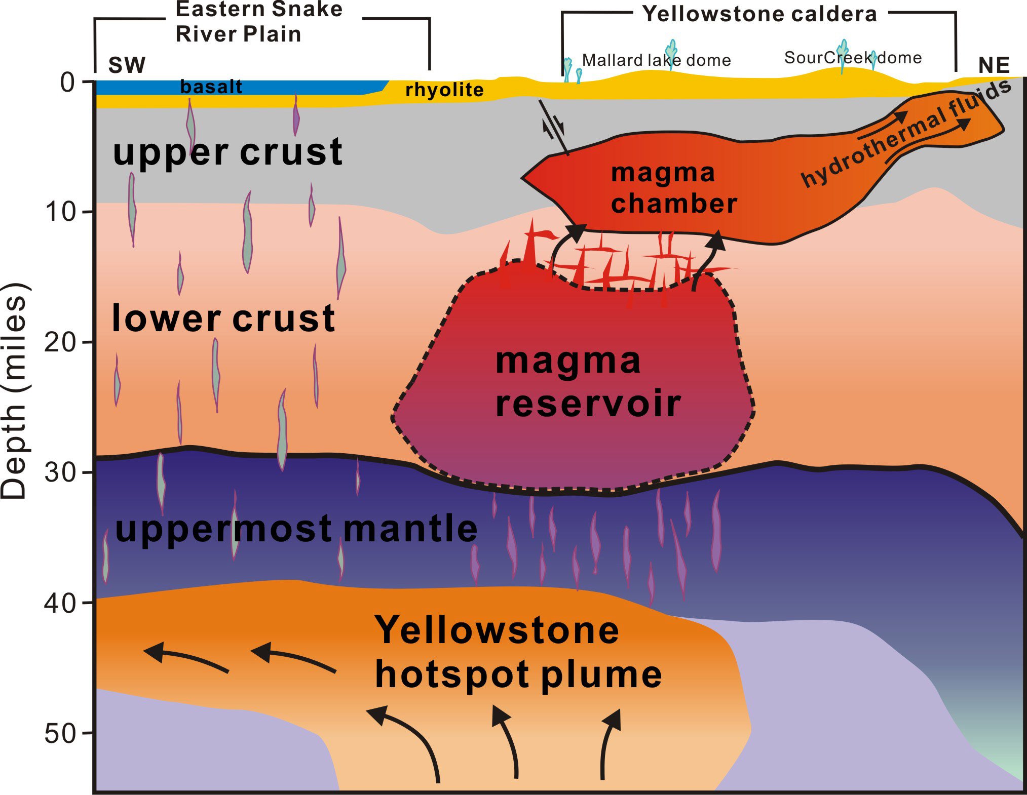
This animation shows the underground volcanic plumbing system beneath the Yellowstone supervolcano in Wyoming, as revealed by a new University of Utah seismic imaging study. The green lines represent the boundary of Yellowstone National Park. The study focused on Earth’s crust, shows the previously known magma chamber (orange) about 3 to 9 miles beneath the surface, and reveals a previously unknown magma reservoir (red) at a depth of 12 to 28 miles. Beneath that is the Yellowstone hotspot plume (yellow) which brings hot rock up from deep within Earth’s mantle. The new study, published online in the journal Science on April 23, 2015, did not focus on the mantle and thus image of the plume has poor resolution and is distorted from what previous imaging studies showed. The black lines show, first, the boundary of the giant volcanic crater or caldera that exploded during Yellowstone’s last supervolcano eruption 640,000 years ago and, second, the outlines of what are called resurgent domes within the caldera. The white dots are locations of earthquakes that were used in the study.
Anatomy of a supervolcano
The study in Science is titled, “The Yellowstone magmatic system from the mantle plume to the upper crust.” Huang, Lin, Farrell, and Smith conducted the research with Brandon Schmandt at the University of New Mexico and Victor Tsai at the California Institute of Technology. Funding came from the University of Utah, National Science Foundation, Brinson Foundation and William Carrico.
Yellowstone is among the world’s largest supervolcanoes, with frequent earthquakes and Earth’s most vigorous continental geothermal system.
The three ancient Yellowstone supervolcano eruptions were only the latest in a series of more than 140 as the North American plate of Earth’s crust and upper mantle moved southwest over the Yellowstone hotspot, starting 17 million years ago at the Oregon-Idaho-Nevada border. The hotspot eruptions progressed northeast before reaching Yellowstone 2 million years ago.
Here is how the new study depicts the Yellowstone system, from bottom to top:
— Previous research has shown the Yellowstone hotspot plume rises from a depth of at least 440 miles (700 kilometers) in Earth’s mantle. Some researchers suspect it originates 1,800 miles (2,900 kilometers)deep at Earth’s core. The plume rises from the depths northwest of Yellowstone. The plume conduit is roughly 50 miles (80 kilometers)wide as it rises through Earth’s mantle and then spreads out like a pancake as it hits the uppermost mantle about 40 miles (64 kilometers) deep. Earlier Utah studies indicated the plume head was 300 miles (480 kilometers) wide. The new study suggests it may be smaller, but the data aren’t good enough to know for sure.
— Hot and partly molten rock rises in dikes from the top of the plume at 40 miles (64 kilometers) depth up to the bottom of the 11,200 cubic miles (46-700 cubic kilometers) magma reservoir, about 28 miles (45 kilometers) deep. The top of this newly discovered blob-shaped magma reservoir is about 12 miles (19 kilometers) deep, Huang says. The reservoir measures 30 miles (48 kilometers) northwest to southeast and 44 miles (71 kilometers) southwest to northeast. “Having this lower magma body resolved the missing link of how the plume connects to the magma chamber in the upper crust,” Lin says.
— The 2,500-cubic-mile (10,400-cubic-kilometer) upper magma chamber sits beneath Yellowstone’s 40-by-25-mile (64-by-40-kilometer) caldera, or giant crater. Farrell says it is shaped like a gigantic frying pan about 3 to 9 miles (5 to 14 kilometers) beneath the surface, with a “handle” rising to the northeast. The chamber is about 19 miles (31 kilometers) from northwest to southeast and 55 miles (89 kilometers) southwest to northeast. The handle is the shallowest, long part of the chamber that extends 10 miles (16 kilometers) northeast of the caldera.
Scientists once thought the shallow magma chamber was 1,000 cubic miles (4,200 cubic kilometers). But at science meetings and in a published paper this past year, Farrell and Smith showed the chamber was 2.5 times bigger than once thought. That has not changed in the new study.
Discovery of the magma reservoir below the magma chamber solves a longstanding mystery: Why Yellowstone’s soil and geothermal features emit more carbon dioxide than can be explained by gases from the magma chamber, Huang says. Farrell says a deeper magma reservoir had been hypothesized because of the excess carbon dioxide, which comes from molten and partly molten rock.
A better, deeper look at Yellowstone
As with past studies that made images of Yellowstone’s volcanic plumbing, the new study used seismic imaging, which is somewhat like a medical CT scan but uses earthquake waves instead of X-rays to distinguish rock of various densities. Quake waves go faster through cold rock, and slower through hot and molten rock.
For the new study, Huang developed a technique to combine two kinds of seismic information: Data from local quakes detected in Utah, Idaho, the Teton Range and Yellowstone by the University of Utah Seismograph Stations and data from more distant quakes detected by the National Science Foundation-funded EarthScope array of seismometers, which was used to map the underground structure of the lower 48 states.
The Utah seismic network has closely spaced seismometers that are better at making images of the shallower crust beneath Yellowstone, while EarthScope’s seismometers are better at making images of deeper structures.
“It’s a technique combining local and distant earthquake data better to look at this lower crustal magma reservoir,” Huang says.
Reference: “The Yellowstone magmatic system from the mantle plume to the upper crust” by Hsin-Hua Huang, Fan-Chi Lin, Brandon Schmandt, Jamie Farrell, Robert B. Smith and Victor C. Tsai, 23 April 2015, Science.
DOI: 10.1126/science.aaa5648
Never miss a breakthrough: Join the SciTechDaily newsletter.
Follow us on Google and Google News.
7 Comments
Tap the lower crust one for geothermal energy. Make the yellowstone area the central spot for huge amounts of energy. Drain the energy off from multiple spots, slowly & steadily. this will lower the heat in the upper one… which should also be tapped, but to a lesser extent. Don’t want to pull out too much energy from the top in such that the top part dries and the heat from the bottom continues to build up even faster and then explode.
The Long Valley Caldera could be tapped as well… and probably should be. Use similar mapping tech as was done in this study to get a richer and more-thorough understanding of it so we don’t just tap some top one only to find out we’ve created a pressure cooker-like situation…
Then use the heat-energy to power turbines… providing California with its much-needed energy supply, as well, use any ‘excess heat/energy’ to heat & distill ocean water pumped in from far out to sea.
Use this distilled water to keep the populous watered (residential, business, commercial, industrial, etc) … with any excess being used to refill the aquifers, reservoirs, lakes and such… as well to provide the agricultural sector with the water *it* so critically needs.
The salt & minerals remaining behind from the distillation can be sorted with the minerals being utilized much like SeaAgri, Inc’s remineralization products on the east coast to remineralize the heavily mineral-depleted soils of Cali’s agricultural lands.
The water *not* needed to be pumped in from elsewhere (read: the Colorado River) can now be re-diverted towards refilling the aquifers, reservoirs, lakes, streams and other in *those* areas..
Though the calculations have yet to be finalized, there is ample energy capabilities in these two sites alone, let alone Valles Caldera in New Mexico and others… to provide the US with more than enough energy to meet any demands we could require.
It would also help to ‘bleed off’ the heat from the magma in such that it could help to reduce the likelihood of an eruption … …or cause one simply out of spite.
any CO2 or other gases that ‘blow out’ during the process can be captured, sorted, and sold to their respective industrial sectors…. CO2 from this would serve as an excellent fertilizer for any greenhouses that California has… or builds… and would drastically help to both reduce the inputs needed, as well increase the return on the growth rates, health, and overall quality of product from these greenhouses … as well, neutralize any climate change consequences of these otherwise ‘fossilized’ (or at least subterranean) carbon stores from making it to both the surface then the atmosphere.
The resulting carbon from the increased biomass yields could be gasified via pyrolysis (utilizing the heat from the magma no doubt) to produce biochar… which could then be incorporated into the fields, farther increasing the sequestration of said carbon, as well also helping to reduce inputs & increase outputs of the subsequent fields.
This is excellent science here and it should be both expanded as well put to good use as quickly as possible.
Your ideas are awesome.
Nice blog. Thank you very much
Thank you so much
Pffssshhh… I knew that!
Really useful. I really enjoyed reading this post.
The entire Yosemite system should be filled in with Spackle, then sanded and painted with latex eggshell. This big hole in the ground has been an open eyesore for too many years. Time to fix it.