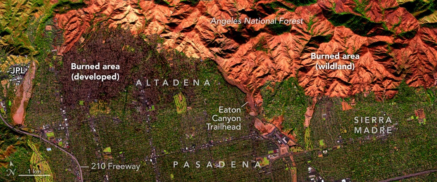
NASA’s AVIRIS-3 instrument captured striking false-color images of the Eaton fire in Los Angeles, providing a unique perspective on the devastation across Altadena, Pasadena, and surrounding areas.
These images assist in assessing damage and analyzing environmental changes due to the fire. As the fire’s containment progresses, NASA continues to support local emergency services with data essential for recovery and planning.
NASA’s AVIRIS-3 Wildfire Surveillance
On the afternoon of January 11, 2025, NASA’s AVIRIS-3 (Airborne Visible/Infrared Imaging Spectrometer-3), mounted on a B200 aircraft, flew over Los Angeles County to capture detailed images of areas impacted by wildfires.
The false-color images reveal the destruction caused by the Eaton fire, which affected Altadena and parts of Pasadena, Arcadia, and Sierra Madre. In the images, charred trees and buildings in urban areas appear dark brown, while burned wildland areas, especially within the Angeles National Forest, are depicted in shades of orange.
Tracking the Spread and Impact of the Eaton Fire
The Eaton fire ignited in the hills of Eaton Canyon, near Altadena, on the evening of January 7. By 10:30 a.m. the next day, the fire had quickly grown to cover more than 10,000 acres (40 square kilometers), according to Cal Fire. Around the time of this image on January 11, it had expanded to 14,117 acres (57 square kilometers), and the Los Angeles County Fire Department reported it was about 15 percent contained.

The AVIRIS-3 optical sensor collects data in 286 bands in the electromagnetic spectrum, ranging from visible violet light at a wavelength of 380 nanometers to shortwave infrared at 2,500 nanometers. In the past, AVIRIS images have been useful for investigating fire behavior and the effects of fire emissions. They are also used for post-fire analyses, such as fire severity, area burned, soil erosion, and other environmental changes.
Utilizing NASA’s Data for Fire Damage Assessment
“In addition to assisting with damage assessments, these data may help us understand the chemical composition and toxic nature of ash in the post-fire environment and how it redistributes over time via wind and water flows, with subsequent data acquisitions,” said Michael Falkowski, manager of NASA’s wildland fire program.
As of the morning of January 15, the Eaton fire had stopped expanding, and it was 45 percent contained. Preliminary estimates indicate that thousands of structures were destroyed, according to Cal Fire.
Support and Resources for Fire-Affected Regions
NASA’s Disasters Response Coordination System has been activated to support agencies responding to the fires, including the California Governor’s Office of Emergency Services. Response activities are centered on two primary requests from the local emergency managers: damage assessment information on built infrastructure, and impacts of air quality and human health risks. The team will be posting maps and data products on its open-access mapping portal as new information becomes available.
Explore interactive maps of these images on the AVIRIS data portal.
NASA Earth Observatory images annotated by Lauren Dauphin using data from Airborne Visible / Infrared Imaging Spectrometer-3 (AVIRIS-3) instrument, via NASA Earthdata Search.
Never miss a breakthrough: Join the SciTechDaily newsletter.
Follow us on Google and Google News.
1 Comment
We discovered big black holes, we discovered big galaxies, we discovered big starbursts, but this information is not useful for our daily life. After two thousand years of history, we still haven’t discovered all the underground cities, two thousand meters underground, under the bed of every There is a big city, a city that is full of secrets. In those cities, the superpower countries know what is going on underground, but they don’t want other countries to know about the secrets and treasures of the underground. These countries only secretly explore the underground cities. They said that all the people of the countries should work to explore the underground cities